Earth
ID: 4879
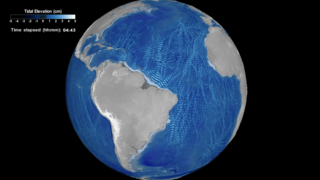
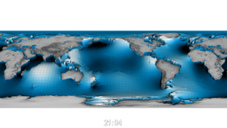
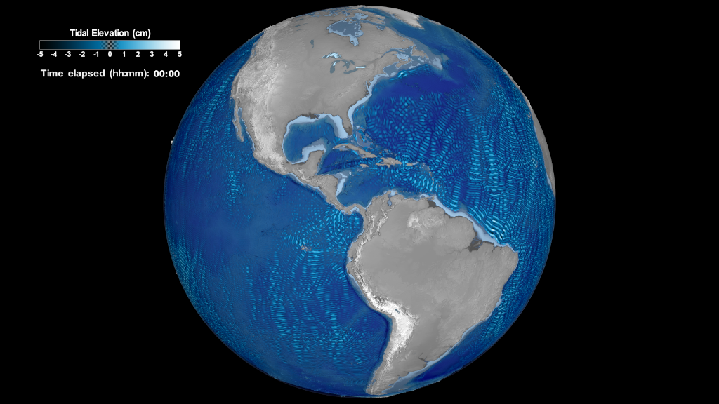
The data-driven visualization sequences on this page use data from NASA Goddard’s Space Flight Center internal tides simulation run and aim to showcase the largest tides around the world, along with their patterns and directions. The largest or most energetic tides are generated in regions with steep bathymetry and along mid-ocean ridges, such as in the Hawaiian Ridge, Tahiti, Macquarie Ridge and Luzon Strait.
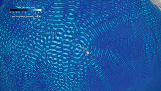
Once generated along the ridges, the internal tides propagate away, both northwards and southwards. Their characteristic wavelength -- about 50 to 100 km from peak to trough -- is determined by details of the ocean's stratification, which depends on water temperature and salinity. The internal tides are capable of propagating great distances away from the ridges, sometime thousands of kilometers.
Within the water column the vertical displacement of water in these waves is large, often tens of meters, and even larger in a few places. But at the ocean surface, the displacement is tiny, only a few cm. Yet satellite altimeters are capable of measuring those small surface waves if we average the altimeter measurements over many years. The data utilized on these visualizations are predicted internal tides based on such multi-year analyses of satellite altimetry. The methodology of such analyses is described in publications: doi.org/10.1175/JPO-D-18-0127.1 doi.org/10.1175/JPO-D-15-0065.1
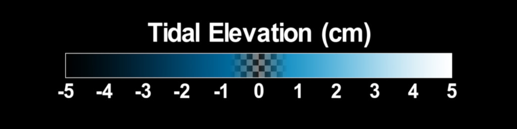
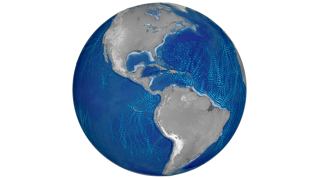
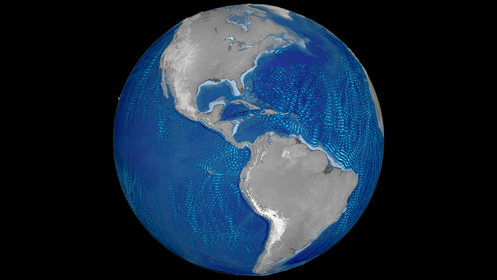
The visualization sequences feature a rotating Earth, where internal tides data are mapped on water surface over a cyclical period of a day (24 hours) accompanied with a colormap and a timestamp. The internal tides data are mapped to a dark blue-to-white sequential colormap to illustrate the levels below (dark blue/deep) and above (white/high) water surface level. The tide data have been interpolated linearly to fade between the hourly steps and cycle through smoothly. The ocean is filled with steep underwater topography, creating many sources of internal tides seen all over the global ocean seen in the data visualizations. The propagation patterns from these many sources interfere constructively and destructively, giving rise to the many complicated patterns.
In the visualizations the vertically exaggerated by 15x GTOPO30 relief model, utilizes a divergent gray-to-light blue colormap to separate over land terrain from shallow bathymetry. The dry land is mapped to greys (dark gray/low to white/high) and shallow bathymetry to light blues. In areas over water and of shallow bathymetry (light blue) internal tides data values are close to zero and have been filtered out, as in these areas the activity of tides is minimal.
Although the surface expression of internal tides, being only a few cm, seems insignificant, it provides oceanographers with a unique way to map and study the much larger internal water motion. These internal waves are an important source of mechanical energy in the ocean, and they are thought to play a key role in mixing warm upper water with cold deeper water, which is a key part of the ocean's thermohaline circulation.
Data Sources:
The rest of this webpage offers additional frames, layers and colorbar information, associated with the development of this data-driven visualization.
Internal Tides: Global Views
The data-driven visualization sequences on this page use data from NASA Goddard’s Space Flight Center internal tides simulation run and aim to showcase the largest tides around the world, along with their patterns and directions. The largest or most energetic tides are generated in regions with steep bathymetry and along mid-ocean ridges, such as in the Hawaiian Ridge, Tahiti, Macquarie Ridge and Luzon Strait.
Once generated along the ridges, the internal tides propagate away, both northwards and southwards. Their characteristic wavelength -- about 50 to 100 km from peak to trough -- is determined by details of the ocean's stratification, which depends on water temperature and salinity. The internal tides are capable of propagating great distances away from the ridges, sometime thousands of kilometers.
Within the water column the vertical displacement of water in these waves is large, often tens of meters, and even larger in a few places. But at the ocean surface, the displacement is tiny, only a few cm. Yet satellite altimeters are capable of measuring those small surface waves if we average the altimeter measurements over many years. The data utilized on these visualizations are predicted internal tides based on such multi-year analyses of satellite altimetry. The methodology of such analyses is described in publications: doi.org/10.1175/JPO-D-18-0127.1 doi.org/10.1175/JPO-D-15-0065.1
The visualization sequences feature a rotating Earth, where internal tides data are mapped on water surface over a cyclical period of a day (24 hours) accompanied with a colormap and a timestamp. The internal tides data are mapped to a dark blue-to-white sequential colormap to illustrate the levels below (dark blue/deep) and above (white/high) water surface level. The tide data have been interpolated linearly to fade between the hourly steps and cycle through smoothly. The ocean is filled with steep underwater topography, creating many sources of internal tides seen all over the global ocean seen in the data visualizations. The propagation patterns from these many sources interfere constructively and destructively, giving rise to the many complicated patterns.
In the visualizations the vertically exaggerated by 15x GTOPO30 relief model, utilizes a divergent gray-to-light blue colormap to separate over land terrain from shallow bathymetry. The dry land is mapped to greys (dark gray/low to white/high) and shallow bathymetry to light blues. In areas over water and of shallow bathymetry (light blue) internal tides data values are close to zero and have been filtered out, as in these areas the activity of tides is minimal.
Although the surface expression of internal tides, being only a few cm, seems insignificant, it provides oceanographers with a unique way to map and study the much larger internal water motion. These internal waves are an important source of mechanical energy in the ocean, and they are thought to play a key role in mixing warm upper water with cold deeper water, which is a key part of the ocean's thermohaline circulation.
Data Sources:
- Internal Tides data from NASA Goddard's Space Flight Center simulation run. The data are hourly over a period of a day (24 hours) with latitude bounds in the range [-66°, 66°]. For the visualizations featured on this page, the tide data have been interpolated linearly to fade between the hourly steps and cycle through smoothly.
- Global 30 Arc-Second Elevation (GTOPO 30) from U.S. Geological Survey (USGS). GTOPO30 is a global raster digital elevation model (DEM) with a horizontal grid spacing of 30 arc seconds (approximately 1 kilometer). GTOPO30 was derived from several raster and vector sources of topographic information. The data-driven visualizations featured on this page utilize the GTOPO30 model to represent the three-dimensional features of over land terrain and submarine topography world-wide. doi: 10.5066/F7DF6PQS.
- Blue Marble: Next Generation was produced by Reto Stöckli, NASA Earth Observatory (NASA Goddard Space Flight Center). Citation: Reto Stöckli, Eric Vermote, Nazmi Saleous, Robert Simmon and David Herring.
The Blue Marble Next Generation – A true color earth dataset including seasonal dynamics from MODIS, October 17, 2005.The visualization on this page utilizes Blue Marble data to mask water bodies from overland terrain.
The rest of this webpage offers additional frames, layers and colorbar information, associated with the development of this data-driven visualization.
Used Elsewhere In
Related
Visualization Credits
Helen-Nicole Kostis (USRA): Lead Visualizer
Greg Shirah (NASA/GSFC): Visualizer
Nadya Vinogradova-Shiffer (NASA/HQ): Lead Scientist
Richard Ray (NASA/GSFC): Lead Scientist
Leann Johnson (Global Science and Technology, Inc.): Project Support
Eric Sokolowsky (Global Science and Technology, Inc.): Project Support
Laurence Schuler (ADNET Systems, Inc.): Technical Support
Ian Jones (ADNET Systems, Inc.): Technical Support
Please give credit for this item to:
NASA's Scientific Visualization Studio
NASA's Scientific Visualization Studio
Science Paper:
Zaron, E. D. (2019). Baroclinic Tidal Sea Level from Exact-Repeat Mission Altimetry, Journal of Physical Oceanography, 49(1), 193-210. Retrieved Jan 22, 2021, doi.org/10.1175/JPO-D-18-0127.1
Ray, R. D., & Zaron, E. D. (2016). M2 Internal Tides and Their Observed Wavenumber Spectra from Satellite Altimetry, Journal of Physical Oceanography, 46(1), 3-22. Retrieved Jan 22, 2021, doi.org/10.1175/JPO-D-15-0065.1
Short URL to share this page:
https://svs.gsfc.nasa.gov/4879
Data Used:
Note: While we identify the data sets used in these visualizations, we do not store any further details nor the data sets themselves on our site.
Keywords:
SVS >> HDTV
DLESE >> Physical oceanography
GCMD >> Earth Science >> Oceans
GCMD >> Earth Science >> Oceans >> Tides
GCMD >> Earth Science >> Oceans >> Bathymetry/Seafloor Topography >> Ocean Plateaus/Ridges
GCMD >> Earth Science >> Oceans >> Coastal Processes >> Sea Level Rise
GCMD >> Location >> Hawaiian Islands
SVS >> Hyperwall
NASA Science >> Earth
SVS >> Ocean
GCMD keywords can be found on the Internet with the following citation: Olsen, L.M., G. Major, K. Shein, J. Scialdone, S. Ritz, T. Stevens, M. Morahan, A. Aleman, R. Vogel, S. Leicester, H. Weir, M. Meaux, S. Grebas, C.Solomon, M. Holland, T. Northcutt, R. A. Restrepo, R. Bilodeau, 2013. NASA/Global Change Master Directory (GCMD) Earth Science Keywords. Version 8.0.0.0.0
Zaron, E. D. (2019). Baroclinic Tidal Sea Level from Exact-Repeat Mission Altimetry, Journal of Physical Oceanography, 49(1), 193-210. Retrieved Jan 22, 2021, doi.org/10.1175/JPO-D-18-0127.1
Ray, R. D., & Zaron, E. D. (2016). M2 Internal Tides and Their Observed Wavenumber Spectra from Satellite Altimetry, Journal of Physical Oceanography, 46(1), 3-22. Retrieved Jan 22, 2021, doi.org/10.1175/JPO-D-15-0065.1
Short URL to share this page:
https://svs.gsfc.nasa.gov/4879
Data Used:
GTOPO30 Topography and Bathymetry
Data Compilation - USGSSRTM/SIR-C/DEM
Terra and Aqua/MODIS/Blue Marble: Next Generation also referred to as: BMNG
Credit:
The Blue Marble data is courtesy of Reto Stockli (NASA/GSFC).
The Blue Marble data is courtesy of Reto Stockli (NASA/GSFC).
Coastline - Northwest Hawaiian Islands (NWHI)
Data Compilation - HawaiiStateGISInternal Ocean Tides
Model
Internal Tides data from NASA Goddard's Space Flight Center simulation run. The data are hourly over a period of a
day (24 hours) with latitude bounds in the range [-66°, 66°].
POC: Richard Ray (NASA/GSFC)
Credit:
NASA Goddard Space Flight Center
NASA Goddard Space Flight Center
Keywords:
SVS >> HDTV
DLESE >> Physical oceanography
GCMD >> Earth Science >> Oceans
GCMD >> Earth Science >> Oceans >> Tides
GCMD >> Earth Science >> Oceans >> Bathymetry/Seafloor Topography >> Ocean Plateaus/Ridges
GCMD >> Earth Science >> Oceans >> Coastal Processes >> Sea Level Rise
GCMD >> Location >> Hawaiian Islands
SVS >> Hyperwall
NASA Science >> Earth
SVS >> Ocean
GCMD keywords can be found on the Internet with the following citation: Olsen, L.M., G. Major, K. Shein, J. Scialdone, S. Ritz, T. Stevens, M. Morahan, A. Aleman, R. Vogel, S. Leicester, H. Weir, M. Meaux, S. Grebas, C.Solomon, M. Holland, T. Northcutt, R. A. Restrepo, R. Bilodeau, 2013. NASA/Global Change Master Directory (GCMD) Earth Science Keywords. Version 8.0.0.0.0


