Earth
ID: 5011
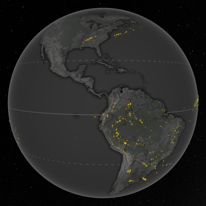
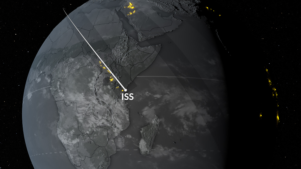
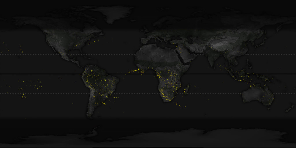
The Lightning Imaging Sensor (LIS) on the International Space Station (ISS) detects lightning occurring in the Earth’s tropical and mid-latitude regions. The LIS provides datasets consisting of near-real time and non-quality controlled data as well as final quality controlled datasets that are manually reviewed. This data uncovers the variability and distribution of lightning and can be used for storm detection and lightning-atmosphere interaction studies.
This visualization shows the global distribution of lightning strikes between January 2017 and July 2023 using the final quality controlled science dataset. Each data point contains the latitude and longitude of the strike as well as the time it was detected by the LIS. A roving window of 10 days was used to visualize the seasonal patterns of lightning.
Science on a Sphere (SOS) Content
This section contains materials for SOS.
SOS playlist file: playlist.sos
SOS label file: labels.txt
Lightning Events Detected from the International Space Station (ISS) 2017-2023
This visualization shows the global distribution of lightning strikes between January 2017 and July 2023 using the final quality controlled science dataset. Each data point contains the latitude and longitude of the strike as well as the time it was detected by the LIS. A roving window of 10 days was used to visualize the seasonal patterns of lightning.
Science on a Sphere (SOS) Content
This section contains materials for SOS.
SOS playlist file: playlist.sos
SOS label file: labels.txt
Visualization Credits
Michala Garrison (SSAI): Lead Visualizer
Greg Shirah (NASA/GSFC): Visualizer
Kel Elkins (USRA): Visualizer
Alex Kekesi (Global Science and Technology, Inc.): Visualizer
Greg Shirah (NASA/GSFC): Visualizer
Kel Elkins (USRA): Visualizer
Alex Kekesi (Global Science and Technology, Inc.): Visualizer
Please give credit for this item to:
NASA's Scientific Visualization Studio
NASA's Scientific Visualization Studio
Science Paper:
Blakeslee, Richard J. 2020. Quality Controlled Lightning Imaging Sensor (LIS) on International Space Station (ISS) Science Data [NC 2017-2020]. Dataset available online from the NASA Global Hydrology Resource Center DAAC, Huntsville, Alabama, U.S.A.
Short URL to share this page:
https://svs.gsfc.nasa.gov/5011
Data Used:
Note: While we identify the data sets used in these visualizations, we do not store any further details nor the data sets themselves on our site.
Keywords:
SVS >> Lightning
SVS >> Hyperwall
SVS >> Science On a Sphere
SVS >> International Space Station
SVS >> ISS
NASA Science >> Earth
SVS >> Lightning Imaging Sensor
SVS >> Earth Information Center
SVS >> EIC (Earth Information Center) Display
Blakeslee, Richard J. 2020. Quality Controlled Lightning Imaging Sensor (LIS) on International Space Station (ISS) Science Data [NC 2017-2020]. Dataset available online from the NASA Global Hydrology Resource Center DAAC, Huntsville, Alabama, U.S.A.
Short URL to share this page:
https://svs.gsfc.nasa.gov/5011
Data Used:
CPC (Climate Prediction Center) Cloud Composite
Data Compilation - Climate Prediction Center (CPC)
Global cloud cover from multiple satellites
Gray Earth with Shaded Relief, Hypsography, and Flat Water also referred to as: Gray Earth
Natrual EarthLightning Imaging Sensor (LIS)/Quality Controlled Lightning Imaging Sensor (LIS) on International Space Station (ISS) Science Data V1 also referred to as: International Space Station (ISS) Lightning Imaging Sensor (LIS)
NASA Global Hydrometeorology Resource Center DAAC
The Quality Controlled Lightning Imaging Sensor (LIS) on International Space Station (ISS) Science Data dataset was collected by the LIS instrument mounted on the ISS and are used to detect the distribution and variability of total lightning occurring in the Earth’s tropical and subtropical regions.
MODIS/Land Cover Climate Modeling Grid (CMG) also referred to as: MCD12C1
Model - USGS
The Terra and Aqua combined Moderate Resolution Imaging Spectroradiometer (MODIS) Land Cover Climate Modeling Grid (CMG) (MCD12C1) Version 6 data product provides a spatially aggregated and reprojected version of the tiled MCD12Q1 Version 6 data product. The dataset provides global land cover types at yearly intervals using International Geosphere-Biosphere Programme (IGBP), University of Maryland (UMD), and Leaf Area Index (LAI) classification schemes.
Credit:
Friedl, M., D. Sulla-Menashe. MCD12C1 MODIS/Terra+Aqua Land Cover Type Yearly L3 Global 0.05Deg CMG V006. 2015, distributed by NASA EOSDIS Land Processes DAAC, https://doi.org/10.5067/MODIS/MCD12C1.006. Accessed 2022-08-25.
Friedl, M., D. Sulla-Menashe. MCD12C1 MODIS/Terra+Aqua Land Cover Type Yearly L3 Global 0.05Deg CMG V006. 2015, distributed by NASA EOSDIS Land Processes DAAC, https://doi.org/10.5067/MODIS/MCD12C1.006. Accessed 2022-08-25.
Keywords:
SVS >> Lightning
SVS >> Hyperwall
SVS >> Science On a Sphere
SVS >> International Space Station
SVS >> ISS
NASA Science >> Earth
SVS >> Lightning Imaging Sensor
SVS >> Earth Information Center
SVS >> EIC (Earth Information Center) Display


