Earth
ID: 4735
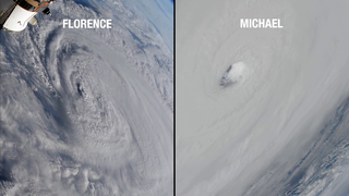
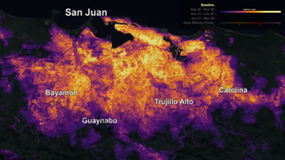
In September 2017, Hurricane Maria struck Puerto Rico head-on as a Category 4 storm with winds topping 155 miles per hour. The storm damaged homes, flooded towns, devastated the island's forests and caused the longest electricity black-out in U.S. history.
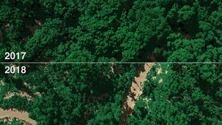
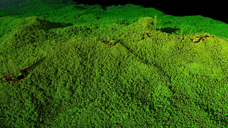
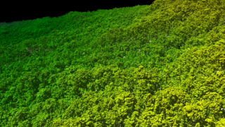
Hurricane Maria's lashing rain and winds transformed Puerto Rico's lush tropical rainforest landscape. Research scientist Doug Morton of Goddard was part of the team of NASA researchers who had surveyed Puerto Rico's forests six months before the storm with Goddard’s Lidar, Hyperspectral, and Thermal (G-LiHT) Airborne Imager, a system designed to study the structure and species composition of Puerto Rican forests. Shooting 600,000 laser pulses per second, G-LiHT produces a 3D view of the forest structure in high resolution. In April 2018, post-Maria, they went back and surveyed the same tracks as in 2017.
Comparing the before and after data, the team found that 40 to 60 percent of the tall trees that formed the canopy of the forest either lost large branches, were snapped in half or were uprooted by strong winds.
"Maria gave the island's forests a haircut," said Morton. "The island lost so many large trees that forests were shortened by one-third. We basically saw 60 years' worth of what we would consider natural treefall disturbances happen in one day."
This version was shown at the Association for Computing Machinery (ACM) / Special Interest Group on GRAPHics (SIGGRAPH) Computer Animation Festival (CAF) on July 29, 2019 at the Microsoft Theater in Los Angeles, CA. It will then be part of the ACM/SIGGRAPH CAF traveling show after that.
NASA Surveys Hurricane Damage to Puerto Rico's Forests (Data Viz Version)
Hurricane Maria's lashing rain and winds transformed Puerto Rico's lush tropical rainforest landscape. Research scientist Doug Morton of Goddard was part of the team of NASA researchers who had surveyed Puerto Rico's forests six months before the storm with Goddard’s Lidar, Hyperspectral, and Thermal (G-LiHT) Airborne Imager, a system designed to study the structure and species composition of Puerto Rican forests. Shooting 600,000 laser pulses per second, G-LiHT produces a 3D view of the forest structure in high resolution. In April 2018, post-Maria, they went back and surveyed the same tracks as in 2017.
Comparing the before and after data, the team found that 40 to 60 percent of the tall trees that formed the canopy of the forest either lost large branches, were snapped in half or were uprooted by strong winds.
"Maria gave the island's forests a haircut," said Morton. "The island lost so many large trees that forests were shortened by one-third. We basically saw 60 years' worth of what we would consider natural treefall disturbances happen in one day."
This version was shown at the Association for Computing Machinery (ACM) / Special Interest Group on GRAPHics (SIGGRAPH) Computer Animation Festival (CAF) on July 29, 2019 at the Microsoft Theater in Los Angeles, CA. It will then be part of the ACM/SIGGRAPH CAF traveling show after that.
Used Elsewhere In
Source Material
Alternate Version
Related
Visualization Credits
Alex Kekesi (Global Science and Technology, Inc.): Lead Data Visualizer
Matthew R. Radcliff (USRA): Lead Producer
Doug C. Morton (NASA/GSFC): Lead Scientist
Kel Elkins (USRA): Data Visualizer
Greg Shirah (NASA/GSFC): Data Visualizer
Horace Mitchell (NASA/GSFC): Data Visualizer
Samson K. Reiny (Wyle Information Systems): Producer
Hyeungu Choi (GST): Scientist
Laurence Schuler (ADNET Systems, Inc.): Technical Support
Ian Jones (ADNET Systems, Inc.): Technical Support
Please give credit for this item to:
NASA's Goddard Space Flight Center
NASA's Goddard Space Flight Center
Short URL to share this page:
https://svs.gsfc.nasa.gov/4735
Data Used:
Note: While we identify the data sets used in these visualizations, we do not store any further details nor the data sets themselves on our site.
This item is part of these series:
Narrated Movies
Lidar
Keywords:
DLESE >> Agricultural science
DLESE >> Atmospheric science
DLESE >> Biology
DLESE >> Forestry
SVS >> HDTV
SVS >> Lidar
DLESE >> Natural hazards
GCMD >> Earth Science >> Agriculture >> Forest Science
GCMD >> Earth Science >> Agriculture >> Forest Science >> Forest Conservation
GCMD >> Earth Science >> Agriculture >> Forest Science >> Forest Management
GCMD >> Earth Science >> Atmosphere >> Atmospheric Phenomena >> Hurricanes
GCMD >> Earth Science >> Biosphere >> Terrestrial Ecosystems >> Forests
GCMD >> Location >> Puerto Rico
NASA Science >> Earth
SVS >> Hurricane Maria
NASA Earth Science Focus Areas >> Weather and Atmospheric Dynamics
NASA Earth Science Focus Areas >> Earth Surface and Interior
GCMD keywords can be found on the Internet with the following citation: Olsen, L.M., G. Major, K. Shein, J. Scialdone, S. Ritz, T. Stevens, M. Morahan, A. Aleman, R. Vogel, S. Leicester, H. Weir, M. Meaux, S. Grebas, C.Solomon, M. Holland, T. Northcutt, R. A. Restrepo, R. Bilodeau, 2013. NASA/Global Change Master Directory (GCMD) Earth Science Keywords. Version 8.0.0.0.0
https://svs.gsfc.nasa.gov/4735
Data Used:
Airplane/G-LiHT/LiDAR 3D point cloud also referred to as: LiDAR
Observed Data - NASA/GSFC - 2017-2018This item is part of these series:
Narrated Movies
Lidar
Keywords:
DLESE >> Agricultural science
DLESE >> Atmospheric science
DLESE >> Biology
DLESE >> Forestry
SVS >> HDTV
SVS >> Lidar
DLESE >> Natural hazards
GCMD >> Earth Science >> Agriculture >> Forest Science
GCMD >> Earth Science >> Agriculture >> Forest Science >> Forest Conservation
GCMD >> Earth Science >> Agriculture >> Forest Science >> Forest Management
GCMD >> Earth Science >> Atmosphere >> Atmospheric Phenomena >> Hurricanes
GCMD >> Earth Science >> Biosphere >> Terrestrial Ecosystems >> Forests
GCMD >> Location >> Puerto Rico
NASA Science >> Earth
SVS >> Hurricane Maria
NASA Earth Science Focus Areas >> Weather and Atmospheric Dynamics
NASA Earth Science Focus Areas >> Earth Surface and Interior
GCMD keywords can be found on the Internet with the following citation: Olsen, L.M., G. Major, K. Shein, J. Scialdone, S. Ritz, T. Stevens, M. Morahan, A. Aleman, R. Vogel, S. Leicester, H. Weir, M. Meaux, S. Grebas, C.Solomon, M. Holland, T. Northcutt, R. A. Restrepo, R. Bilodeau, 2013. NASA/Global Change Master Directory (GCMD) Earth Science Keywords. Version 8.0.0.0.0


