Earth
ID: 12991
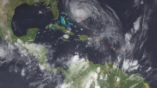
On September 20, 2017, Hurricane Maria barreled across Puerto Rico with winds of up to 155 miles per hour and battering rain that flooded towns, knocked out communications networks and destroyed the power grid. In the rugged central mountains and the lush northeast, Maria unleashed its fury as fierce winds completely defoliated the tropical forests and broke and uprooted trees, and heavy rainfall triggered thousands of landslides that mowed over swaths of steep mountainsides.
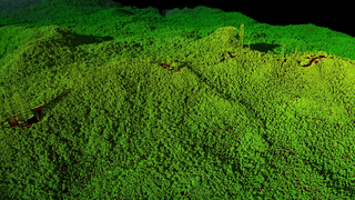
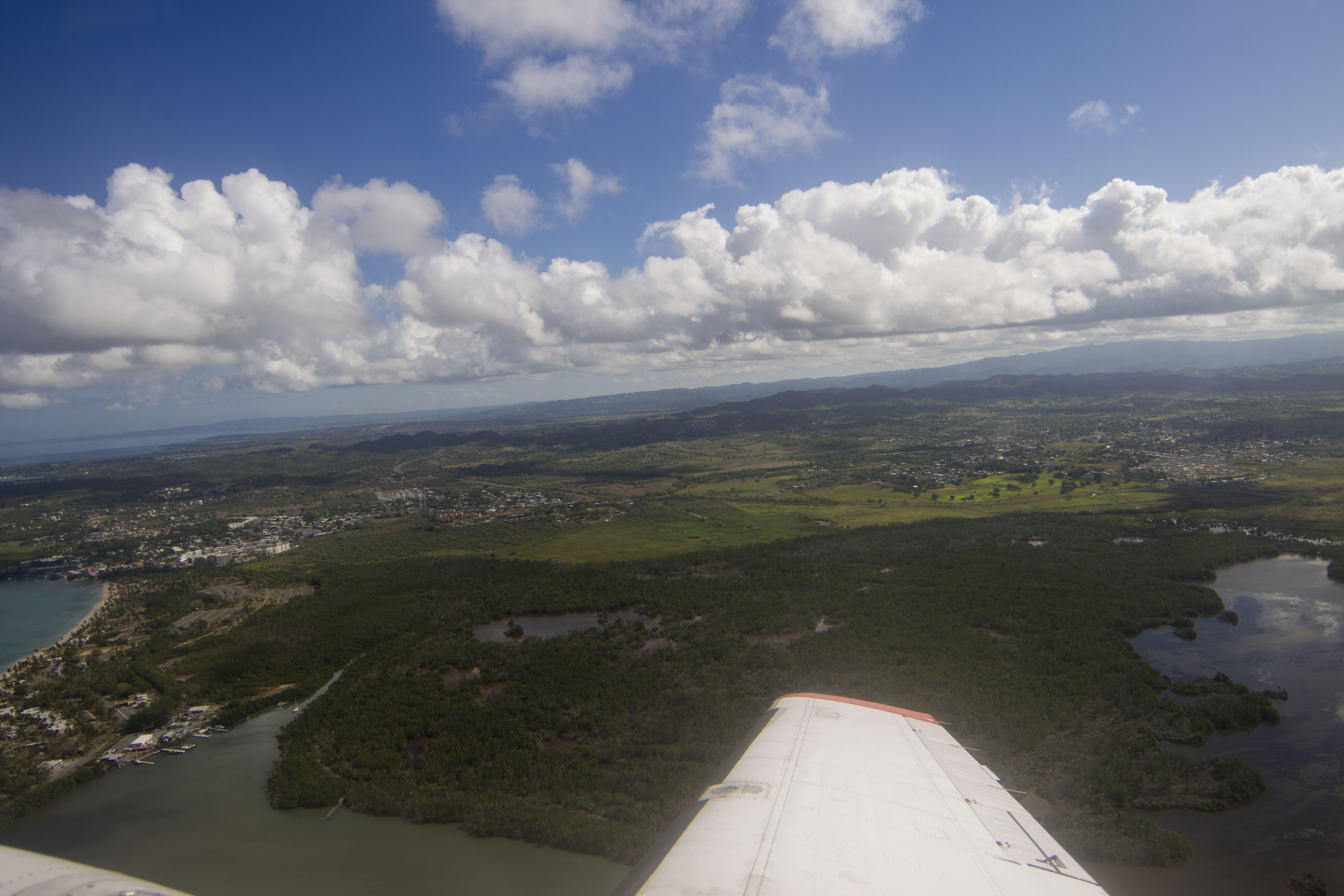
NASA’s Earth-observing satellites monitor the world’s forests to detect seasonal changes in vegetation cover or abrupt forest losses from deforestation, but at a coarse resolution. To get a more detailed look, NASA flew an airborne instrument called Goddard’s Lidar, Hyperspectral and Thermal Airborne Imager, or G-LiHT. From the belly of a small aircraft flying one thousand feet above the trees, G-LiHT collected multiple measurements of forests across Puerto Rico, including high-resolution photographs, surface temperatures and the heights and structure of the vegetation.
The U.S. Forest Service, the U.S. Fish and Wildlife Service, the Federal Emergency Management Agency and NASA provided funding for the airborne campaign. The team flew many of the same tracks with G-LiHT as it had in the spring of 2017, months before Hurricane Maria made landfall, as part of a study of how tropical forests regrow on abandoned agricultural land. The before-and-after comparison shows forests across the island still reeling from the hurricane’s impact.
NASA Surveys Hurricane Damage to Puerto Rico's Forests
NASA’s Earth-observing satellites monitor the world’s forests to detect seasonal changes in vegetation cover or abrupt forest losses from deforestation, but at a coarse resolution. To get a more detailed look, NASA flew an airborne instrument called Goddard’s Lidar, Hyperspectral and Thermal Airborne Imager, or G-LiHT. From the belly of a small aircraft flying one thousand feet above the trees, G-LiHT collected multiple measurements of forests across Puerto Rico, including high-resolution photographs, surface temperatures and the heights and structure of the vegetation.
The U.S. Forest Service, the U.S. Fish and Wildlife Service, the Federal Emergency Management Agency and NASA provided funding for the airborne campaign. The team flew many of the same tracks with G-LiHT as it had in the spring of 2017, months before Hurricane Maria made landfall, as part of a study of how tropical forests regrow on abandoned agricultural land. The before-and-after comparison shows forests across the island still reeling from the hurricane’s impact.
Related
For More Information
Credits
Matthew R. Radcliff (USRA): Lead Producer
Samson K. Reiny (Wyle Information Systems): Lead Writer
Alex Kekesi (Global Science and Technology, Inc.): Animator
Doug C. Morton (NASA/GSFC): Scientist
Bruce Cook (NASA/GSFC): Scientist
Matthew R. Radcliff (USRA): Videographer
Samson K. Reiny (Wyle Information Systems): Videographer
Samson K. Reiny (Wyle Information Systems): Lead Writer
Alex Kekesi (Global Science and Technology, Inc.): Animator
Doug C. Morton (NASA/GSFC): Scientist
Bruce Cook (NASA/GSFC): Scientist
Matthew R. Radcliff (USRA): Videographer
Samson K. Reiny (Wyle Information Systems): Videographer
Please give credit for this item to:
NASA's Goddard Space Flight Center
NASA's Goddard Space Flight Center
Short URL to share this page:
https://svs.gsfc.nasa.gov/12991
This item is part of these series:
Narrated Movies
Lidar
Keywords:
DLESE >> Atmospheric science
DLESE >> Biology
SVS >> HDTV
SVS >> Lidar
DLESE >> Natural hazards
GCMD >> Earth Science >> Agriculture >> Forest Science >> Forest Protection
GCMD >> Earth Science >> Atmosphere >> Atmospheric Phenomena >> Hurricanes
GCMD >> Earth Science >> Biosphere >> Terrestrial Ecosystems >> Forests
NASA Science >> Earth
SVS >> Hurricane Maria
SVS >> Hurricane Irma
GCMD keywords can be found on the Internet with the following citation: Olsen, L.M., G. Major, K. Shein, J. Scialdone, S. Ritz, T. Stevens, M. Morahan, A. Aleman, R. Vogel, S. Leicester, H. Weir, M. Meaux, S. Grebas, C.Solomon, M. Holland, T. Northcutt, R. A. Restrepo, R. Bilodeau, 2013. NASA/Global Change Master Directory (GCMD) Earth Science Keywords. Version 8.0.0.0.0


