Earth
ID: 12476

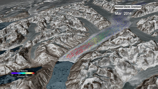
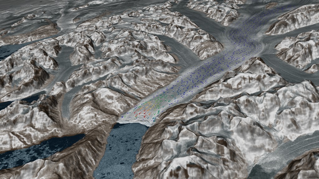
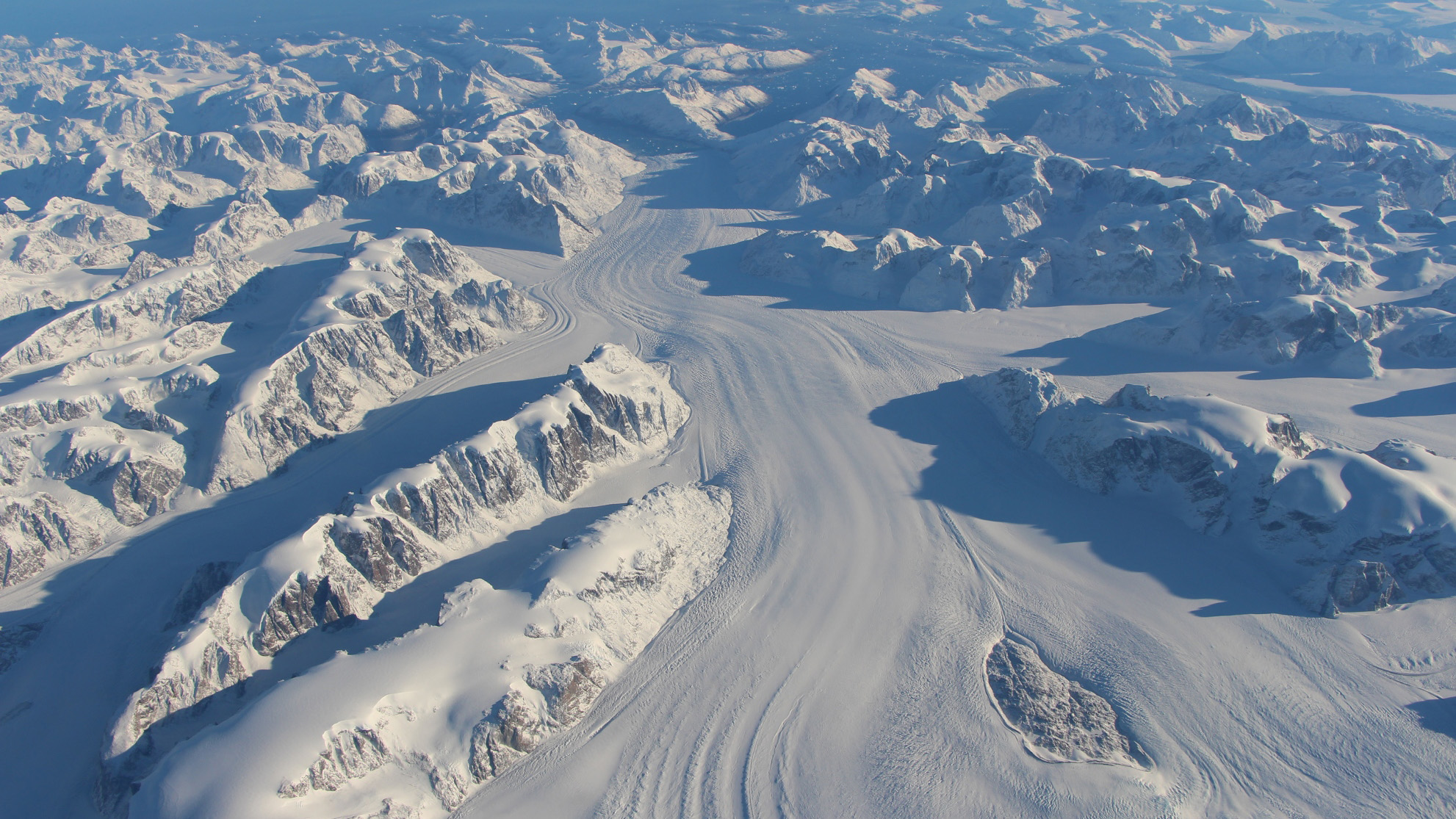
Glaciers and ice sheets move in unique and sometimes surprising patterns, as evidenced by a new capability that uses satellite images to map the speed of flowing ice in Greenland, Antarctica and mountain ranges around the world. With imagery and data from Landsat 8, a joint mission of NASA and the U.S. Geological Survey, scientists are providing a near-real-time view of every large glacier and ice sheet on Earth. Researchers aim to better understand how ice flow is changing worldwide by integrating information about atmosphere and ocean conditions to determine what causes these ice sheets to change – and what that means for how much ice is flowing into the ocean. That could help provide critical information to coastal communities that will be most impacted by sea level rise. The Heimdal glacier in Southeast Greenland shown here can travel more than 33 feet (10 meters) per day in early summer and less than 20 feet (6 meters) per day by October. Watch the video to learn more.

At Glacial Speed
Source Material

Related Story
For More Information
Story Credits
Lead Visualizer/Animator:
Cindy Starr (Global Science and Technology, Inc.)
Visualizers/Animators:
Horace Mitchell (NASA/GSFC)
Greg Shirah (NASA/GSFC)
Lead Producer:
Matthew R. Radcliff (USRA)
Producer:
Kathryn Mersmann (USRA)
Scientists:
Twila Moon (University of Bristol)
Mark Fahnestock (University of Alaska)
Ted Scambos (NSIDC)
Alex S. Gardner (NASA/JPL CalTech)
Project Support:
Joycelyn Thomson Jones (NASA/GSFC)
Eric Sokolowsky (Global Science and Technology, Inc.)
Leann Johnson (Global Science and Technology, Inc.)
Lead Writer:
Kate Ramsayer (Telophase)
Please give credit for this item to:
NASA's Scientific Visualization Studio.
Photo of Heimdal glacier courtesy of NASA/John Sonntag.
NASA's Scientific Visualization Studio.
Photo of Heimdal glacier courtesy of NASA/John Sonntag.
Short URL to share this page:
https://svs.gsfc.nasa.gov/12476
Mission:
Landsat
Data Used:
Note: While we identify the data sets used in these visualizations, we do not store any further details nor the data sets themselves on our site.
Keywords:
SVS >> HDTV
GCMD >> Earth Science >> Hydrosphere >> Glaciers/Ice Sheets
GCMD >> Earth Science >> Cryosphere >> Glaciers/Ice Sheets >> Glacier Motion/Ice Sheet Motion
GCMD >> Earth Science >> Cryosphere >> Glaciers/Ice Sheets >> Glaciers
GCMD >> Earth Science >> Hydrosphere >> Glaciers/Ice Sheets >> Glacier Motion/Ice Sheet Motion
GCMD >> Location >> Greenland
SVS >> Glaciers
SVS >> App
NASA Science >> Earth
GCMD >> Earth Science >> Terrestrial Hydrosphere >> Glaciers/ice Sheets
GCMD >> Earth Science >> Terrestrial Hydrosphere >> Glaciers/ice Sheets >> Glacier Motion/ice Sheet Motion
GCMD >> Earth Science >> Terrestrial Hydrosphere >> Glaciers/ice Sheets >> Glaciers
GCMD keywords can be found on the Internet with the following citation: Olsen, L.M., G. Major, K. Shein, J. Scialdone, S. Ritz, T. Stevens, M. Morahan, A. Aleman, R. Vogel, S. Leicester, H. Weir, M. Meaux, S. Grebas, C.Solomon, M. Holland, T. Northcutt, R. A. Restrepo, R. Bilodeau, 2013. NASA/Global Change Master Directory (GCMD) Earth Science Keywords. Version 8.0.0.0.0
https://svs.gsfc.nasa.gov/12476
Mission:
Landsat
Data Used:
RADARSAT-1/SAR
2000-2013
Credit:
Additional credit goes to Canadian Space Agency, RADARSAT International Inc.
Additional credit goes to Canadian Space Agency, RADARSAT International Inc.
Greenland Mapping Project (GIMP) Digital Elevation Model also referred to as: GIMP Greenland DEM
Data Compilation - Courtesy of Ian Howat, OSU - 2003-2009Landsat-8/Global Land Ice Velocity also referred to as: GoLIVE
Analysis - Oct. 2013 - Oct. 2016
Credit:
Mark Fahnstock (Univ. of Alaska), Twila Moon (Univ. of Bristol), Ted Scambos (Univ. of Colorado/NSIDC), Marin Klinger (Univ. of Colorado/NSIDC), Alex Gardner (JPL), Terry Haran (Univ. of Colorado/NSIDC)
Mark Fahnstock (Univ. of Alaska), Twila Moon (Univ. of Bristol), Ted Scambos (Univ. of Colorado/NSIDC), Marin Klinger (Univ. of Colorado/NSIDC), Alex Gardner (JPL), Terry Haran (Univ. of Colorado/NSIDC)
Keywords:
SVS >> HDTV
GCMD >> Earth Science >> Hydrosphere >> Glaciers/Ice Sheets
GCMD >> Earth Science >> Cryosphere >> Glaciers/Ice Sheets >> Glacier Motion/Ice Sheet Motion
GCMD >> Earth Science >> Cryosphere >> Glaciers/Ice Sheets >> Glaciers
GCMD >> Earth Science >> Hydrosphere >> Glaciers/Ice Sheets >> Glacier Motion/Ice Sheet Motion
GCMD >> Location >> Greenland
SVS >> Glaciers
SVS >> App
NASA Science >> Earth
GCMD >> Earth Science >> Terrestrial Hydrosphere >> Glaciers/ice Sheets
GCMD >> Earth Science >> Terrestrial Hydrosphere >> Glaciers/ice Sheets >> Glacier Motion/ice Sheet Motion
GCMD >> Earth Science >> Terrestrial Hydrosphere >> Glaciers/ice Sheets >> Glaciers
GCMD keywords can be found on the Internet with the following citation: Olsen, L.M., G. Major, K. Shein, J. Scialdone, S. Ritz, T. Stevens, M. Morahan, A. Aleman, R. Vogel, S. Leicester, H. Weir, M. Meaux, S. Grebas, C.Solomon, M. Holland, T. Northcutt, R. A. Restrepo, R. Bilodeau, 2013. NASA/Global Change Master Directory (GCMD) Earth Science Keywords. Version 8.0.0.0.0


