Sun
ID: 4887
In addition to the NASA missions used in research for space weather (see 2020 Heliophysics Fleet) there are additional missions operated by NOAA used for space weather forecasting. As of spring 2020, here's a tour of the NASA and NOAA Heliophysics fleets from the near-Earth satellites out to the inner solar system.
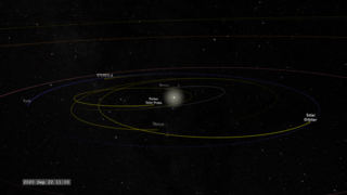
Heliophysics Sentinels 2020 (Forecast Version)
The satellite orbits are color coded for their observing program:
Magenta: TIM (Thermosphere, Ionosphere, Mesosphere) observations Yellow: solar observations and imagery Cyan: Geospace and magnetosphere Violet: Heliospheric observations
Near-Earth Fleet:
- Hinode: Observes the Sun in multiple wavelengths up to x-rays. SVS page
- TIMED: Studies the upper layers (40-110 miles up) of Earth's atmosphere. SVS page
- ICON: Works with GOLD on studies of the ionosphere.
- AIM: Images and measures noctilucent clouds. SVS page
- IRIS: Interface Region Imaging Spectrograph is designed to take high-resolution spectra and images of the region between the solar photosphere and solar atmosphere. SVS page
- SET: Space Environment Testbed exploring radiation-hardening technologies
Geosynchronous Fleet:
- GOES East & GOES West: The GOES satellites provide continuous imagery of Earth's western hemisphere and monitor the solar X-ray flux.
- SDO: Solar Dynamics Observatory keeps the Sun under continuous observation at 16 megapixel resolution. SVS page
- GOLD: Global-scale Observations of the Limb and Disk is a spectroscopic imager for studying the ionosphere.
Geospace Fleet:
- Geotail: Conducts measurements of electrons and ions in the Earth's magnetotail. SVS page
- Magnetospheric Multi-scale (MMS): This is a group of four satellites which fly in formation to measure how particles and fields in the magnetosphere vary in space and time. SVS page
- THEMIS: This is a fleet of three satellites to study how magnetospheric instabilities produce substorms. Two of the original five satellites were moved into lunar orbit to become THEMIS-ARTEMIS. SVS page
- IBEX: The Interstellar Boundary Explorer measures the flux of neutral atoms from the heliopause. SVS page
Lunar Orbiting Fleet:
- THEMIS-ARTEMIS: Two of the THEMIS satellites were moved into lunar orbit to study the interaction of the Earth's magnetosphere with the Moon. SVS page
Sun-Earth Lagrange Point One Fleet:
The L1 point is a Lagrange Point between the Sun and the Earth. Spacecraft can orbit this location for continuous coverage of the Sun.- DSCOVR: Observes Earth and measures the solar wind.
- SOHO: Studies the Sun with cameras and a multitude of other instruments. SVS page
- ACE: Measures the composition and characteristics of the solar wind. SVS page
- Wind: Measures particle flows and fields in the solar wind. SVS page
Solar Orbiting Fleet:
- STEREO-A: The remaining STEREO spaceraft orbits the Sun in roughly the same orbit as Earth. SVS page
- Parker Solar Probe: On an orbit that takes it closer to the Sun than any other mission. SVS page
- Solar Orbiter: On an orbit that takes it to high solar latitudes. SVS page
Alternate Version
Related
For More Information
Visualization Credits
Tom Bridgman (Global Science and Technology, Inc.): Lead Visualizer
Laurence Schuler (ADNET Systems, Inc.): Technical Support
Ian Jones (ADNET Systems, Inc.): Technical Support
Laurence Schuler (ADNET Systems, Inc.): Technical Support
Ian Jones (ADNET Systems, Inc.): Technical Support
Please give credit for this item to:
NASA's Scientific Visualization Studio
NASA's Scientific Visualization Studio
Short URL to share this page:
https://svs.gsfc.nasa.gov/4887
Missions:
ACE
THEMIS and ARTEMIS
Geotail
GOES-R
Hinode (Solar-b)
IBEX
Ionospheric Connection Explorer (ICON)
IRIS: Interface Region Imaging Spectrograph
Magnetospheric Multiscale (MMS)
SDO
SOHO
Parker Solar Probe
Solar Orbiter Collaboration
STEREO
THEMIS
TIMED
Voyager
Wind
Deep Space Climate Observatory (DSCOVR)
Global-scale Observations of the Limb and Disk (GOLD)
Space Environment Testbeds (SET)
Data Used:
Note: While we identify the data sets used in these visualizations, we do not store any further details nor the data sets themselves on our site.
This item is part of this series:
Heliophysics Fleet
Keywords:
SVS >> SOHO
SVS >> Hyperwall
SVS >> Solar Dynamics Observatory
SVS >> ACE
SVS >> Hinode
SVS >> STEREO
SVS >> Spacecraft >> Voyager
SVS >> Satellite Orbit
SVS >> MMS
NASA Science >> Sun
SVS >> GOES-R
SVS >> Solar Orbiter
SVS >> IRIS Mission
SVS >> DSCOVR
SVS >> Parker Solar Probe
https://svs.gsfc.nasa.gov/4887
Missions:
ACE
THEMIS and ARTEMIS
Geotail
GOES-R
Hinode (Solar-b)
IBEX
Ionospheric Connection Explorer (ICON)
IRIS: Interface Region Imaging Spectrograph
Magnetospheric Multiscale (MMS)
SDO
SOHO
Parker Solar Probe
Solar Orbiter Collaboration
STEREO
THEMIS
TIMED
Voyager
Wind
Deep Space Climate Observatory (DSCOVR)
Global-scale Observations of the Limb and Disk (GOLD)
Space Environment Testbeds (SET)
Data Used:
SSCweb also referred to as: SSCweb ephemerides
Ephemeris - NASA/GSFC Space Physics Data Facility - 2020-01-01 to 2020-05-24
Satellite ephemerides
Space-Track Two-Line Elements also referred to as: Space-Track TLE
Ephemeris - NORAD - 2020-04-01 to 2020-06-01
Satellite ephemerides
DE 431
Ephemeris - JPL - 2020-01-01 to 2020-12-31
Planetary ephemerides SPICE kernel
This item is part of this series:
Heliophysics Fleet
Keywords:
SVS >> SOHO
SVS >> Hyperwall
SVS >> Solar Dynamics Observatory
SVS >> ACE
SVS >> Hinode
SVS >> STEREO
SVS >> Spacecraft >> Voyager
SVS >> Satellite Orbit
SVS >> MMS
NASA Science >> Sun
SVS >> GOES-R
SVS >> Solar Orbiter
SVS >> IRIS Mission
SVS >> DSCOVR
SVS >> Parker Solar Probe


