Earth
ID: 10864

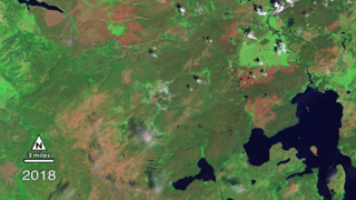
A combination of lightning, drought and human activity caused fires to scorch more than one-third of Yellowstone National Park in the summer of 1988. Within a year, burn scars cast a sharp outline on the 793,880 acres affected by fire, distinguishing wide sections of recovering forest, meadows, grasslands and wetlands from unburned areas of the park. After more than two decades, satellite instruments can still detect these scars from space. In the time-lapse video below, a collection of false-color images collected by USGS-NASA Landsat satellites from 1987 to 2011 show the burning and gradual regeneration of Yellowstone following the 1988 fire season. Watch as burn scars (dark red) quickly replace large expanses of healthy green vegetation (dark green) by 1989. Notice how the scars slowly fade over time as new vegetation begins to grow and heal the landscape.


Yellowstone's Burn Scars
There is a newer version of this story located here: https://svs.gsfc.nasa.gov/11029
Newer Version
Related Story

For More Information
Story Credits
Lead Visualizer/Animator:
Eric Sokolowsky (GST)
Visualizers/Animators:
Horace Mitchell (NASA/GSFC)
Steve Maher (NASA/GSFC)
Robert Simmon (Sigma Space Corporation)
Video Editor:
Matthew R. Radcliff (USRA)
Interviewee:
Jeffrey Masek (NASA/GSFC)
Producer:
Matthew R. Radcliff (USRA)
Lead Scientists:
Robert Stevens (USGS)
Jeffrey Masek (NASA/GSFC)
Videographer:
Matthew R. Radcliff (USRA)
Lead Writer:
Kayvon Sharghi (USRA)
Please give credit for this item to:
NASA's Goddard Space Flight Center
Image of 1988 Mirror Plateau fire courtesy of Jim Peaco, National Park Service
Image of fires burning in Yellowstone National Park on Sept. 24, 2009 courtesy of Image Science & Analysis Laboratory, NASA Johnson Space Center.
NASA's Goddard Space Flight Center
Image of 1988 Mirror Plateau fire courtesy of Jim Peaco, National Park Service
Image of fires burning in Yellowstone National Park on Sept. 24, 2009 courtesy of Image Science & Analysis Laboratory, NASA Johnson Space Center.
Short URL to share this page:
https://svs.gsfc.nasa.gov/10864
Keywords:
SVS >> App
NASA Science >> Earth
https://svs.gsfc.nasa.gov/10864
Keywords:
SVS >> App
NASA Science >> Earth


