The Colors of Life, The Colors of the World - Page One
A PALETTE OF COLORS,
A PLANET REVEALED
Note: There are numerous images and animations contained on this page. This may result in longer download times. All SeaWiFS visualization courtesy: NASA/GSFC and ORBIMAGE
 Click
on pic to enlarge
Click
on pic to enlarge
PULSE OF THE PLANET - EXPLOSION IN THE GALAPAGOS
SeaWiFS images documented the rapid demise of El Nino in the waters around the Galapagos Islands. The images show a explosion in plankton growth as the warm El Nino waters blamed for choking off essential ocean nutrients are replaced by deep, cold waters. The false color images, which document plankton concentrations a period from May 9 - 24 1998, show that life in the region to the west archipelago returned in remarkable abundance. High concentrations are shown red. Areas blocked by clouds are shown in white.
SeaWiFS AROUND THE NATION
Throughout the duration of the SeaWiFS project, affiliated researchers have produced a series of high-resolution images to help them better understand seasonal changes in ocean and land-based plant life in regions around the U.S. Each sequence begins with true color images and transitions to computer-enhanced images that highlight plankton and sediment concentrations.


Charleston, SC Miami, FL New Orleans, LA
Click on pics to enlarge
Click for TIFF images of Charleston, Miami, New Orleans
Click on city names UNDER PICS for animations of each
A UNIQUE VANTAGE FOR TEMPESTS
SeaWiFS provided a unique perspective to a variety of natural disasters, including fires in Florida, Mexico, and Indonesia, floods in China and the progress of Hurricanes such as Georges.
Click on each picture to enlarge. Click on the title for TIFF image.
Florida Fires - June 1998
 animation
Yucatan Peninsula Fires - May
1998 animation
Flooding on the Yangtze River -
August 1998  animation
Flooding on the Songhua River
 animation
Hurricane Georges - June 1998
 Back
to top
Back
to top
 Click
on pic to enlarge
Click
on pic to enlarge
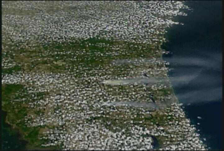
FIRES SEND SMOKE EAST
While fires tormented authorities and residents across the western United States in late summer of 2000, evidence of the disaster's immense scale floated across the country. In this SeaWiFS image taken August 15, 2000, heavy smoke and aerosols can be seen travelling as far East as the Great Lakes. SeaWiFS collected the data for this image, showing the colors of smoke against the wood and grasslands of the United States just as clearly as it can see colors in the ocean. The patches of amber that fade onto the screen show information collected by the space agency's TOMS (Total Ozone Mapping Spectrometer) instrument. The TOMS data shows that heavy smoke from the western blazes significantly raised ambient particulate concentrations more than a thousand miles from the fires themselves.
It's interesting to note that by imaging these intense fires, SeaWiFS managed to capture another phase of the carbon cycle, with trees and other plants giving up long-held carbon to the atmosphere and soil as they oxidized in flames.
 Click
on pic to enlarge
Click
on pic to enlarge
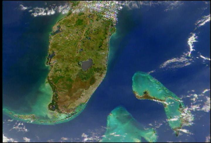
FLOODS IN MOZAMBIQUE
Following weeks of heavy rains in late winter 2000, massive flooding inundated wide tracts of eastern and southern Africa, displacing more than 200,000 people. Torrential rain fell over immense areas. Vastly overflowing rivers sent much of that water rushing towards Mozambique. In the following SeaWiFS image of Cyclone Leon- Eline, taken February 23, notice the wide expanse of territory affected by the storm system.
 Click
on pic to enlarge
Click
on pic to enlarge
DUST IN THE WIND
A massive sandstorm blowing off the desert in northwest Africa blanketed hundreds of thousands of square miles over the eastern Atlantic Ocean with a dense cloud of particles. The nature of this particular storm was first seen by SeaWiFS on Saturday, February 26, 2000 when it had stretched more than 1000 miles out to sea. Storms coupled with currents of rising warm air can lift dust roughly 15,000 feet above the African deserts. Recent studies by the U.S. Geological Survey show links between the decline of coral reefs in the Caribbean to the increasing frequency and intensity of Saharan Dust events.
 Click
on pic to enlarge
Click
on pic to enlarge
SeaWiFS AT THE OLYMPIC GAMES
During the Olympic Games in September, 2000, the SeaWiFS team captured a dramatic mosaic of Australian images. Stitched together in the Scientific Visualization Studio at the Goddard Space Flight Center, the pictures depict the Australian continent in vibrant color. It was across much of the land shown here that 11,000 runners carried the Olympic torch more than 17,000 miles, on a route that ultimately led to the lighting of the flame in Sydney's new stadium. This tour of Australia captures both inland features as well as dramatic oceanic hues from the Great Barrier Reef, the world's largest coral reef.
HOW SeaWiFS WORKS
The satellite is essentially a detector for different colors, or wavelengths, of light. As shown here, sunlight shines down on the ocean. A portion of it gets reflected back into space. That returning light contains information by its color. Light reflecting or passing through phytoplankton appears greenish, and detected by the spacecraft, that data can help determine levels of photosynthetic productivity in the area observed.
 Click
on pic to enlarge
Click
on pic to enlarge
COLORING THE FUTURE--THE MODIS INSTRUMENT
Scientific research is a process dependent on continuity. To properly validate findings, experiments must duplicated, or observations of a phenomenon must be of adequate duration and probity to validate initial findings. The data collected by SeaWiFS is a first step in the process of understanding the planet's carbon cycle. The past three years of data can now stand as a starting point from which newer, more advanced instruments can take the lead and build on the work.
One of those instruments is called MODIS--the Moderate-resolution Imaging Spectroradiometer. It's currently on orbit on the spacecraft called Terra, and a second, similar instrument is being readied for launch on Terra's sibling satellite called Aqua.
MODIS is expected to enable the next phase in ocean productivity research, providing researchers a powerful tool in understanding the processes of life on Earth.
 Click
on pic to enlarge
Click
on pic to enlarge
SeaWiFS: BIG RETURNS FROM A SMALL PACKAGE
SeaWiFS (Sea-Viewing Wide Field of View Sensor) is the scientific portion of the OrbView-2 satellite, orbiting The Earth at an altitude of 423 miles (705 kilometers). By providing a regular picture of the planet's color, SeaWiFS helps researchers learn about the state of the world's interconnected ecosystems. OrbView-2 blasted into space on August 1, 1997 lifted by an extended Pegasus rocket. SeaWiFS is considered a low cost mission, many orders of magnitude less expensive than other Earth observing instruments. In scientific terms, however, this little instrument has proved to be one of the space agency's star performers, it's highly focused mission parameters netting huge scientific returns for researchers studying a wide variety of questions.
Click
here for Page Two
Last Updated 03/27/01
[ back to top | email
us | GSFC Home ]