Earth
ID: 5052
Wildfires leave behind a burn scar with little to no vegetation. Depending on the original biome type and severity of the fire, it may take years for the vegetation to regain its pre-fire biomass. Fire radiative power is an early observational indicator of interest to emergency response providers to prioritize areas with increased risk of mud-slides.
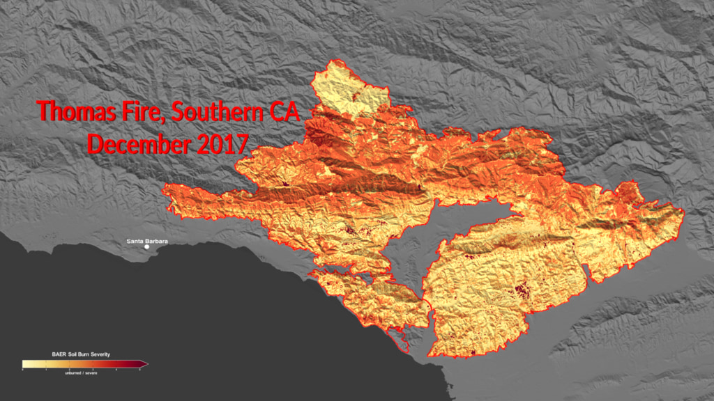
This visualization starts with a wide view of the West Coast of the United States. Regions that experienced fire are shown with red outlines. The camera then zooms in to the Thomas Fire in Southern California. This fire burned about 280,000 acres near Santa Barbara between December 2017 and January 2018. The visualization shows the extent of the fire with a red outline. Burned Area Emergency Response (BAER) soil burn severity data is shown followed by the impact on evapotranspiration, then fire radiative power. The camera then zooms into a region near the coast and shows debris data (depicted as black areas with diagonal white lines).
Post-Fire: Assessing Downstream Effects on Hydrology and Water Quality (Thomas Fire)
This visualization starts with a wide view of the West Coast of the United States. Regions that experienced fire are shown with red outlines. The camera then zooms in to the Thomas Fire in Southern California. This fire burned about 280,000 acres near Santa Barbara between December 2017 and January 2018. The visualization shows the extent of the fire with a red outline. Burned Area Emergency Response (BAER) soil burn severity data is shown followed by the impact on evapotranspiration, then fire radiative power. The camera then zooms into a region near the coast and shows debris data (depicted as black areas with diagonal white lines).
Visualization Credits
Greg Shirah (NASA/GSFC): Lead Visualizer
Michala Garrison (SSAI): Visualizer
Timothy Lahmers (UMD): Scientist
Sujay Kumar (NASA/GSFC): Scientist
Chris Hain (NASA/MSFC): Scientist
Elijah Orland (UMBC): Scientist
Thomas Holmes (NASA/GSFC): Scientist
Forrest Melton (California State University, Monterey Bay): Scientist
Kim Locke (SAIC): Producer
Please give credit for this item to:
NASA's Scientific Visualization Studio
NASA's Scientific Visualization Studio
Short URL to share this page:
https://svs.gsfc.nasa.gov/5052
Data Used:
Note: While we identify the data sets used in these visualizations, we do not store any further details nor the data sets themselves on our site.
Keywords:
DLESE >> Atmospheric science
SVS >> Drought
SVS >> Fire Management
GCMD >> Earth Science >> Climate Indicators >> Drought Indices
GCMD >> Earth Science >> Atmosphere >> Precipitation >> Precipitation Anomalies
GCMD >> Earth Science >> Biosphere >> Ecological Dynamics >> Fire Characteristics
GCMD >> Earth Science >> Climate Indicators >> Fire Weather Indices >> Fire Weather Index
SVS >> Hyperwall
NASA Science >> Earth
GCMD keywords can be found on the Internet with the following citation: Olsen, L.M., G. Major, K. Shein, J. Scialdone, S. Ritz, T. Stevens, M. Morahan, A. Aleman, R. Vogel, S. Leicester, H. Weir, M. Meaux, S. Grebas, C.Solomon, M. Holland, T. Northcutt, R. A. Restrepo, R. Bilodeau, 2013. NASA/Global Change Master Directory (GCMD) Earth Science Keywords. Version 8.0.0.0.0
https://svs.gsfc.nasa.gov/5052
Data Used:
GTOPO30
Model - USGSSRTM/SIR-C/DEM
Landsat/MTBS
Observed Data
Monitoring Trends in Burn Severity
Credit:
https://mtbs.gov
https://mtbs.gov
also referred to as: BAER
Observed Data
Burned Area Emergency Response
also referred to as: Evapotranspiration
Observed Data
Evapotranspiration data were retrieved for the DisALEXI model from OpenET (openetdata.org) under a CCBY4.0 open data license.
Credit:
Melton, F., Huntington, J., Grimm, R., Herring, J., Hall, M., Rollison, D., Erickson, T., Allen, R., Anderson, M., Fisher, J., Kilic, A., Senay, G., volk, J., Hain, C., Johnson, L., Ruhoff, A., Blanenau, P., Bromley, M., Carrara, W., Daudert, B., Doherty, C., Dunkerly, C., Friedrichs, M., Guzman, A., Halverson, G., Hansen, J., Harding, J., Kang, Y., Ketchum, D., Minor, B., Morton, C., Ortega-Salazar, S., Ott, T., Ozdogon, M., Schull, M., Wang, T., Yang, Y., Anderson, R., 2021. OpenET: Filling a Critical Data Gap in Water Management for the Western United States. Journal of the American Water
Melton, F., Huntington, J., Grimm, R., Herring, J., Hall, M., Rollison, D., Erickson, T., Allen, R., Anderson, M., Fisher, J., Kilic, A., Senay, G., volk, J., Hain, C., Johnson, L., Ruhoff, A., Blanenau, P., Bromley, M., Carrara, W., Daudert, B., Doherty, C., Dunkerly, C., Friedrichs, M., Guzman, A., Halverson, G., Hansen, J., Harding, J., Kang, Y., Ketchum, D., Minor, B., Morton, C., Ortega-Salazar, S., Ott, T., Ozdogon, M., Schull, M., Wang, T., Yang, Y., Anderson, R., 2021. OpenET: Filling a Critical Data Gap in Water Management for the Western United States. Journal of the American Water
Suomi NPP and NOAA-20/VIIRS also referred to as: Fire radiative power
Observed Dataalso referred to as: Debris Flow Polygons
Observed Data
Credit:
USGS
USGS
Keywords:
DLESE >> Atmospheric science
SVS >> Drought
SVS >> Fire Management
GCMD >> Earth Science >> Climate Indicators >> Drought Indices
GCMD >> Earth Science >> Atmosphere >> Precipitation >> Precipitation Anomalies
GCMD >> Earth Science >> Biosphere >> Ecological Dynamics >> Fire Characteristics
GCMD >> Earth Science >> Climate Indicators >> Fire Weather Indices >> Fire Weather Index
SVS >> Hyperwall
NASA Science >> Earth
GCMD keywords can be found on the Internet with the following citation: Olsen, L.M., G. Major, K. Shein, J. Scialdone, S. Ritz, T. Stevens, M. Morahan, A. Aleman, R. Vogel, S. Leicester, H. Weir, M. Meaux, S. Grebas, C.Solomon, M. Holland, T. Northcutt, R. A. Restrepo, R. Bilodeau, 2013. NASA/Global Change Master Directory (GCMD) Earth Science Keywords. Version 8.0.0.0.0


