Earth
ID: 2114
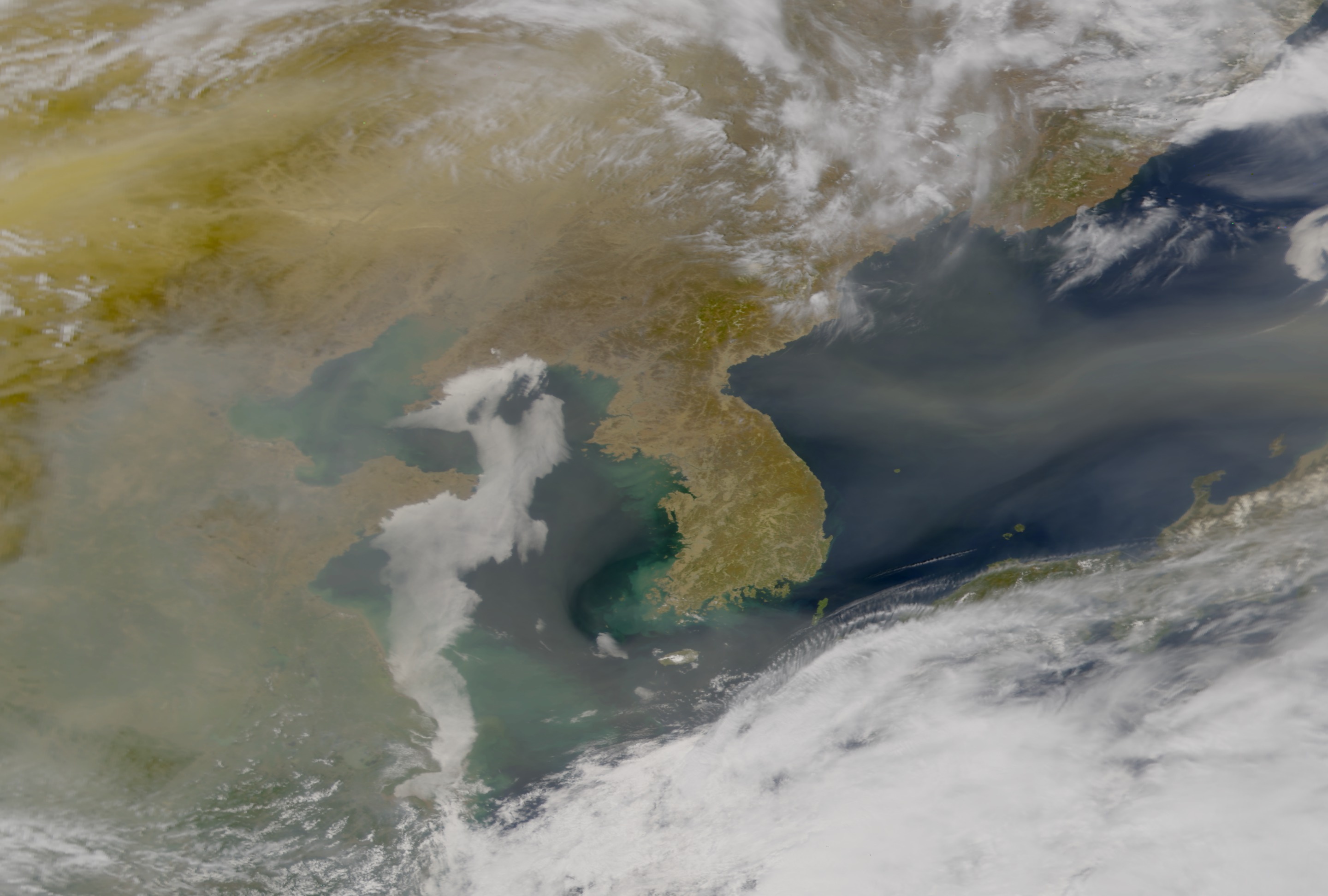
A series of dust clouds originating with distinct wind events over Asia two weeks ago, have made their way across the Pacific and spread a whitish haze across half of the U.S., sources say.
Gene Feldman, a scientist at NASA's Goddard Space Flight Center in Greenbelt, MD said aircraft have been monitoring the particulates in the dust clouds. Apparently, the dust clouds picked up industrial pollution from two of China's largest cities and are now blanketing the mid-Western United States with this matter. Dr. Feldman said, "At one time, the dust cloud was bigger than Japan."
As early as 1998, scientists were claiming that industrial pollution from China was spreading to the United States where pollution in the U.S. was rising to two-thirds the federal health limits. The current storm proves this theory to be true. Pollution from Asia is reaching in the U.S. in alarming amounts.
The particulates in the dust clouds that reduce visibility and cause respiratory problems have not been measured in such high volume since Mt. St. Helens erupted, and even then, the particulates did not reach the ground as they are in this case.
The dust storms could even reach the Eastern U.S., but experts say they will probably dissipate as they move across the midwest.
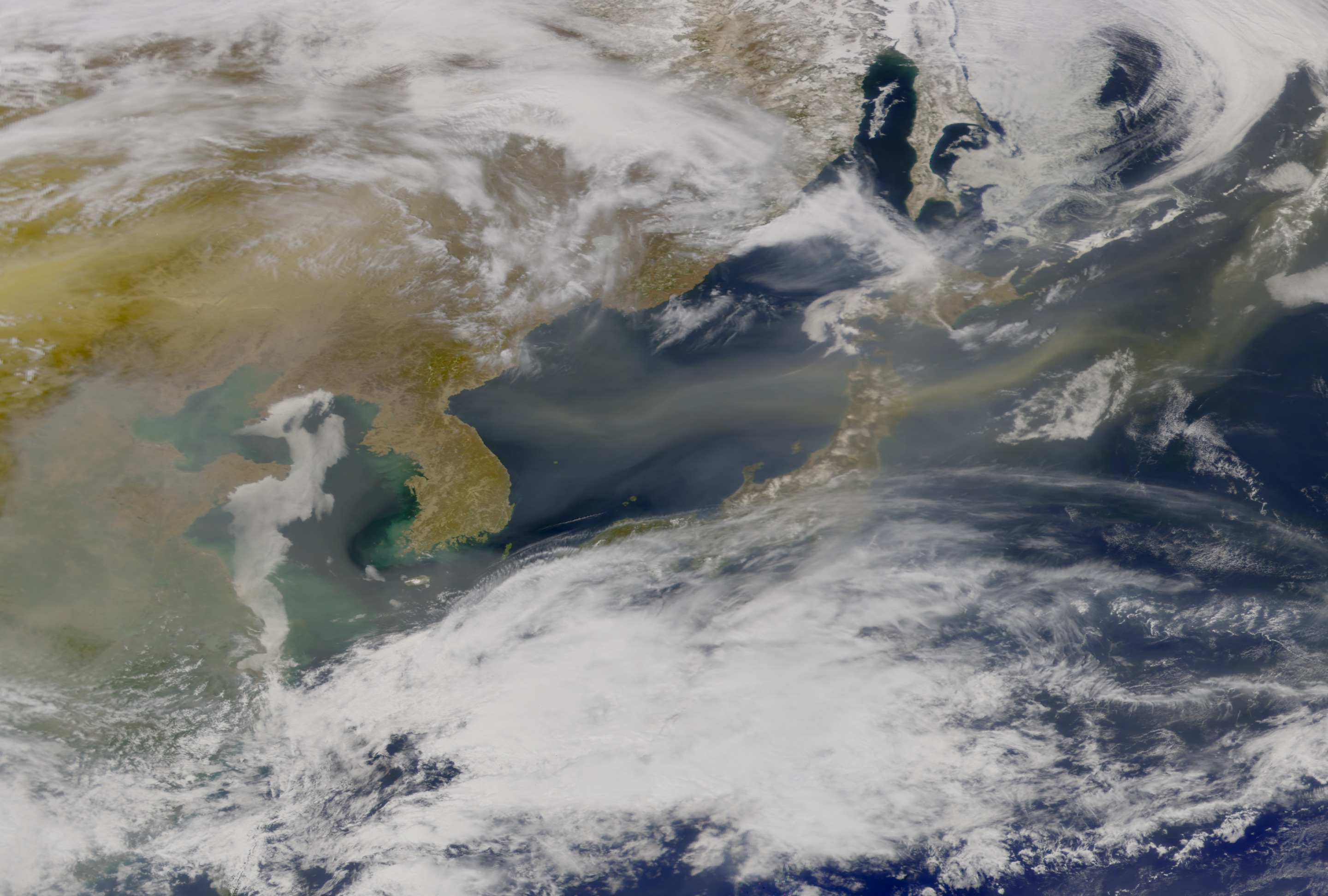

Dust Storms of Asia
Gene Feldman, a scientist at NASA's Goddard Space Flight Center in Greenbelt, MD said aircraft have been monitoring the particulates in the dust clouds. Apparently, the dust clouds picked up industrial pollution from two of China's largest cities and are now blanketing the mid-Western United States with this matter. Dr. Feldman said, "At one time, the dust cloud was bigger than Japan."
As early as 1998, scientists were claiming that industrial pollution from China was spreading to the United States where pollution in the U.S. was rising to two-thirds the federal health limits. The current storm proves this theory to be true. Pollution from Asia is reaching in the U.S. in alarming amounts.
The particulates in the dust clouds that reduce visibility and cause respiratory problems have not been measured in such high volume since Mt. St. Helens erupted, and even then, the particulates did not reach the ground as they are in this case.
The dust storms could even reach the Eastern U.S., but experts say they will probably dissipate as they move across the midwest.
Related
Visualization Credits
Please give credit for this item to:
NASA/Goddard Space Flight Center, The SeaWiFS Project and GeoEye, Scientific Visualization Studio. NOTE: All SeaWiFS images and data presented on this web site are for research and educational use only. All commercial use of SeaWiFS data must be coordinated with GeoEye (NOTE: In January 2013, DigitalGlobe and GeoEye combined to become DigitalGlobe).
NASA/Goddard Space Flight Center, The SeaWiFS Project and GeoEye, Scientific Visualization Studio. NOTE: All SeaWiFS images and data presented on this web site are for research and educational use only. All commercial use of SeaWiFS data must be coordinated with GeoEye (NOTE: In January 2013, DigitalGlobe and GeoEye combined to become DigitalGlobe).
Short URL to share this page:
https://svs.gsfc.nasa.gov/2114
Data Used:
Note: While we identify the data sets used in these visualizations, we do not store any further details nor the data sets themselves on our site.
Keywords:
DLESE >> Atmospheric science
SVS >> Dust
GCMD >> Earth Science >> Atmosphere >> Aerosols
GCMD >> Location >> Asia
NASA Science >> Earth
GCMD keywords can be found on the Internet with the following citation: Olsen, L.M., G. Major, K. Shein, J. Scialdone, S. Ritz, T. Stevens, M. Morahan, A. Aleman, R. Vogel, S. Leicester, H. Weir, M. Meaux, S. Grebas, C.Solomon, M. Holland, T. Northcutt, R. A. Restrepo, R. Bilodeau, 2013. NASA/Global Change Master Directory (GCMD) Earth Science Keywords. Version 8.0.0.0.0
https://svs.gsfc.nasa.gov/2114
Data Used:
SeaStar/SeaWiFS
2001/04/17
NOTE: All SeaWiFS images and data presented on this web site are for research and educational use only. All commercial use of SeaWiFS data must be coordinated with GeoEye
Credit:
NASA/Goddard Space Flight Center, The SeaWiFS Project and GeoEye, Scientific Visualization Studio. NOTE: All SeaWiFS images and data presented on this web site are for research and educational use only. All commercial use of SeaWiFS data must be coordinated with GeoEye (NOTE: In January 2013, DigitalGlobe and GeoEye combined to become one DigitalGlobe.).
NASA/Goddard Space Flight Center, The SeaWiFS Project and GeoEye, Scientific Visualization Studio. NOTE: All SeaWiFS images and data presented on this web site are for research and educational use only. All commercial use of SeaWiFS data must be coordinated with GeoEye (NOTE: In January 2013, DigitalGlobe and GeoEye combined to become one DigitalGlobe.).
Keywords:
DLESE >> Atmospheric science
SVS >> Dust
GCMD >> Earth Science >> Atmosphere >> Aerosols
GCMD >> Location >> Asia
NASA Science >> Earth
GCMD keywords can be found on the Internet with the following citation: Olsen, L.M., G. Major, K. Shein, J. Scialdone, S. Ritz, T. Stevens, M. Morahan, A. Aleman, R. Vogel, S. Leicester, H. Weir, M. Meaux, S. Grebas, C.Solomon, M. Holland, T. Northcutt, R. A. Restrepo, R. Bilodeau, 2013. NASA/Global Change Master Directory (GCMD) Earth Science Keywords. Version 8.0.0.0.0


