Hurricane Ike on September 10, 2008 at 1745 UTC
NASA's TRMM spacecraft observed this view of Hurricane Ike on September 10, 2008 at 1745 UTC or 1:45PM EST. At this time the storm was a category 2 hurricane with sustained winds of 85 knots (97.75 mph), a pressure reading of 958 millibars, and a diameter of 100 miles. The cloud cover in this animation is taken by TRMM's Visible and Infrared Scanner(VIRS) and the GOES spacecraft. The rain structure is taken by TRMM's Tropical Microwave Imager (TMI) and TRMM's Precitation Radar(PR) instruments. TRMM looks underneath of the storm's clouds to reveal the underlying rain structure. The colored isosurface uner the clouds show the rain seen by the PR instrument. This surface is colored according to cloud height where yellow represents 10 km thunderclouds and red represents 15 km or more intense thunderclouds. Ike is expected to generate a 10 to 15 foot storm surge along a 100 mile stretch of the Texas Coast from the eye landfall location.
Hurricane Ike strengthens in the Gulf. TRMM observed this 17 km tower.

Hurricane Ike with the clouds removed.
Hurricane Ike threatens the entire Gulf Coast.
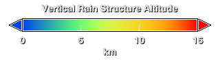
Hurricane Ike's vertical rain structure. The high towers are shown in red.
Credits
Please give credit for this item to:
NASA/Goddard Space Flight Center Scientific Visualization Studio
-
Animator
- Lori Perkins (NASA/GSFC)
-
Scientist
- Scott Braun (NASA/GSFC)
Release date
This page was originally published on Thursday, September 11, 2008.
This page was last updated on Wednesday, May 3, 2023 at 1:55 PM EDT.
Missions
This visualization is related to the following missions:Series
This visualization can be found in the following series:Datasets used in this visualization
-
[GOES]
ID: 22 -
[TRMM: PR]
ID: 109 -
[TRMM: TMI]
ID: 110 -
[TRMM: VIRS]
ID: 111
Note: While we identify the data sets used in these visualizations, we do not store any further details, nor the data sets themselves on our site.