Multi-scale Ultra-high Resolution Sea Surface Temperature (MUR)
These maps are made mostly from the satellite measurements of Sea Surface Temperature (SST), with help from surface observations that come from ships and bouys. Since the 1980's, there are a lot more SST data from satellites than surface observations.
SST is invaluable for weather forecasting. But SST is also important for management of fishery, ocean acoustic communication, and the science including studies of climate and marine life.
To "blend" the SST data from many different satellite is a tricky business. Satellite-based environmental data are usually irregularly sampled and always noisy. Every satellite has a unique sensor that measures SST. The infra-red (IR) type sensor can offer a very high resolution (down to 1 km in horizontal distance) but suffer from contamination by clouds and aerosols that block the signal. The micro-wave (MW) measurements are more reliable because of cloud-penetrating coverage but are coarser (25 km) in resolution and are not useful along the coasts due to contamination from land.
So we are interested in making use of the best characteristics of each sensor data — be it resolution or coverage — and finding an optimal and objective ways to fill the data-voids under the clouds and near the coasts.
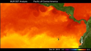
Multiscale Ultra Resolution Sea Surface Temperature on a stationary globe.
Multiscale Ultra Resolution Sea Surface Temperature on a rotating globe.

This is the color bar for the two animations above.
For More Information
Credits
Please give credit for this item to:
NASA/Goddard Space Flight Center
-
Project support
- Leann Johnson (Global Science and Technology, Inc.)
- Eric Sokolowsky (Global Science and Technology, Inc.)
Release date
This page was originally published on Thursday, March 14, 2013.
This page was last updated on Tuesday, November 14, 2023 at 12:21 AM EST.
Datasets used in this visualization
-
MUR SST (Multi-scale Ultra-high Resolution (MUR) Sea Surface Temperature (SST) Analysis)
ID: 845
Note: While we identify the data sets used in these visualizations, we do not store any further details, nor the data sets themselves on our site.
Related
- ID: 30486
 Hyperwall Visual
 - ID: 30487
 Hyperwall Visual