Earth
ID: 5160
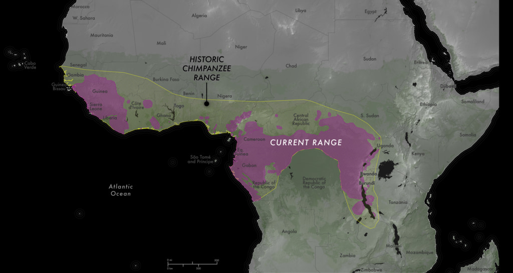
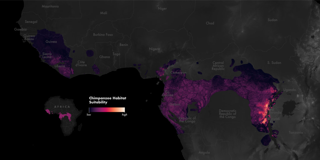
Major biodiversity loss as a result of land-use and land-cover change threatens populations of humans’ closest living relative, the chimpanzee. Continuous monitoring of chimpanzee habitats is necessary for the species’ conservation and one way to do that is through habitat suitability models (HSMs). HSMs use statistical and machine learning to predict the suitability of a location for a species based on environmental descriptors. The Jane Goodall Institute (JGI) uses NASA satellite data to create such models.
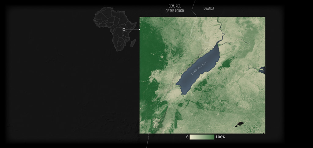
The maps on this page showcase some of the environmental model inputs derived from Landsat imagery and the resulting habitat suitability maps for a section in Uganda and the broader habitat range in Africa. The model inputs shown on this page are 1) tree height, 2) forest loss, 3) tree cover, 4) forest depth, 5) Landsat ETM+ band four, 6) Landsat ETM+ band five, 7) Landsat ETM+ band seven, and 7) normalized difference ratio of band four/band seven.
More information about these HSMs can be found in this paper.
Habitat Suitability Maps

Suitability Model Inputs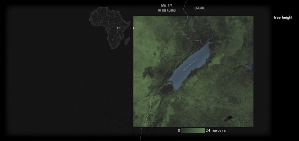

Using NASA Data to Monitor Chimpanzee Habitat Suitability in Africa
The maps on this page showcase some of the environmental model inputs derived from Landsat imagery and the resulting habitat suitability maps for a section in Uganda and the broader habitat range in Africa. The model inputs shown on this page are 1) tree height, 2) forest loss, 3) tree cover, 4) forest depth, 5) Landsat ETM+ band four, 6) Landsat ETM+ band five, 7) Landsat ETM+ band seven, and 7) normalized difference ratio of band four/band seven.
More information about these HSMs can be found in this paper.
Habitat Suitability Maps
Suitability Model Inputs
Used Elsewhere In
Related

Visualization Credits
Michala Garrison (SSAI): Lead Visualizer
Laurence Schuler (ADNET Systems, Inc.): Technical Support
Ian Jones (ADNET Systems, Inc.): Technical Support
Jefferson Beck (KBR Wyle Services, LLC): Producer
Lilian Pintea (The Jane Goodall Institute): Scientist
Laurence Schuler (ADNET Systems, Inc.): Technical Support
Ian Jones (ADNET Systems, Inc.): Technical Support
Jefferson Beck (KBR Wyle Services, LLC): Producer
Lilian Pintea (The Jane Goodall Institute): Scientist
Please give credit for this item to:
NASA's Scientific Visualization Studio
NASA's Scientific Visualization Studio
Science Paper:
Jantz, Samuel M., Lilian Pintea, Janet Nackoney, and Matthew C. Hansen. 2016. "Landsat ETM+ and SRTM Data Provide Near Real-Time Monitoring of Chimpanzee (Pan troglodytes) Habitats in Africa" Remote Sensing 8, no. 5: 427. https://doi.org/10.3390/rs8050427
Short URL to share this page:
https://svs.gsfc.nasa.gov/5160
Data Used:
Note: While we identify the data sets used in these visualizations, we do not store any further details nor the data sets themselves on our site.
Keywords:
SVS >> Habitat
SVS >> Landsat
GCMD >> Earth Science >> Human Dimensions >> Land Use/Land Cover
GCMD >> Earth Science >> Human Dimensions >> Environmental Impacts >> Conservation
NASA Science >> Earth
GCMD keywords can be found on the Internet with the following citation: Olsen, L.M., G. Major, K. Shein, J. Scialdone, S. Ritz, T. Stevens, M. Morahan, A. Aleman, R. Vogel, S. Leicester, H. Weir, M. Meaux, S. Grebas, C.Solomon, M. Holland, T. Northcutt, R. A. Restrepo, R. Bilodeau, 2013. NASA/Global Change Master Directory (GCMD) Earth Science Keywords. Version 8.0.0.0.0
Jantz, Samuel M., Lilian Pintea, Janet Nackoney, and Matthew C. Hansen. 2016. "Landsat ETM+ and SRTM Data Provide Near Real-Time Monitoring of Chimpanzee (Pan troglodytes) Habitats in Africa" Remote Sensing 8, no. 5: 427. https://doi.org/10.3390/rs8050427
Short URL to share this page:
https://svs.gsfc.nasa.gov/5160
Data Used:
SRTM/SIR-C/DEM
Keywords:
SVS >> Habitat
SVS >> Landsat
GCMD >> Earth Science >> Human Dimensions >> Land Use/Land Cover
GCMD >> Earth Science >> Human Dimensions >> Environmental Impacts >> Conservation
NASA Science >> Earth
GCMD keywords can be found on the Internet with the following citation: Olsen, L.M., G. Major, K. Shein, J. Scialdone, S. Ritz, T. Stevens, M. Morahan, A. Aleman, R. Vogel, S. Leicester, H. Weir, M. Meaux, S. Grebas, C.Solomon, M. Holland, T. Northcutt, R. A. Restrepo, R. Bilodeau, 2013. NASA/Global Change Master Directory (GCMD) Earth Science Keywords. Version 8.0.0.0.0


