Earth
ID: 4948
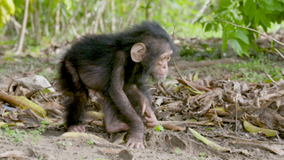
In partnership with the Jane Goodall Institute (JGI), NASA scientists have provided assistance in monitoring, forecasting and in the conservation of habitats across chimpanzee range in Africa. Between 1972 and 1999, significant deforestation had occurred in the region outside the boundary of the Gombe National Park, Tanzania to the detriment of the park's chimpanzee population as well as to the that of the local communities living in the region.
In 2005, JGI initiated a forest monitoring program, training, and in 2009 equipping, community members with GPS-enabled Android smart phones or tablets to report their observations on forests threats and wildlife. Combining NASA remote sensing data with citizen science observations assisted the local communities and district governments in developing and implementing land use plans, leading to improved decision making and facilitating the establishment of village land and district forest reserves.
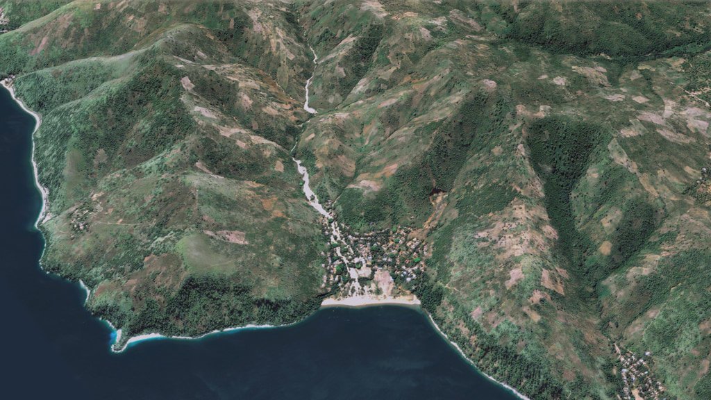
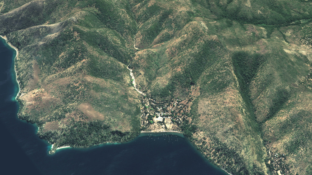
This visualization shows the reforestation that occurred due to this effort in the Kigoma Region of Tanzania, just south of the Gombe National Park between 2005 and 2014. From a global view, we zoom to the village of Kigalye, Tanzania on the coast of Lake Tanganyika. The two visualizations shown here follow the identical view but reflect the state of the region in these two different years. Satellite images from each year are shown blanketing the topography of this region allowing us to compare the forest cover change. We stop at the village of Kigalye in order to view the location where a landslide had done significant damage prior to 2005 and slowly move northward up the valley over Kizuka stream to the southern border of the Gombe National Park.
With the information provided by the forest monitoring program, local communities that are better equipt for planning and managing their natural resources have made a positive impact on forest regeneration in the region.
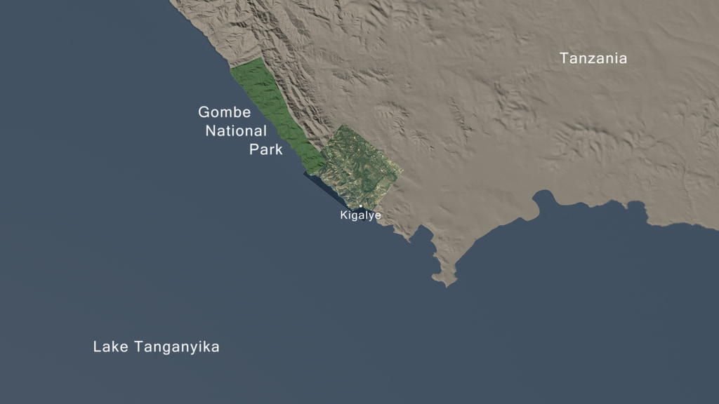
Reforestation in Kigoma region of Tanzania: 2005 - 2014
In partnership with the Jane Goodall Institute (JGI), NASA scientists have provided assistance in monitoring, forecasting and in the conservation of habitats across chimpanzee range in Africa. Between 1972 and 1999, significant deforestation had occurred in the region outside the boundary of the Gombe National Park, Tanzania to the detriment of the park's chimpanzee population as well as to the that of the local communities living in the region.
In 2005, JGI initiated a forest monitoring program, training, and in 2009 equipping, community members with GPS-enabled Android smart phones or tablets to report their observations on forests threats and wildlife. Combining NASA remote sensing data with citizen science observations assisted the local communities and district governments in developing and implementing land use plans, leading to improved decision making and facilitating the establishment of village land and district forest reserves.
This visualization shows the reforestation that occurred due to this effort in the Kigoma Region of Tanzania, just south of the Gombe National Park between 2005 and 2014. From a global view, we zoom to the village of Kigalye, Tanzania on the coast of Lake Tanganyika. The two visualizations shown here follow the identical view but reflect the state of the region in these two different years. Satellite images from each year are shown blanketing the topography of this region allowing us to compare the forest cover change. We stop at the village of Kigalye in order to view the location where a landslide had done significant damage prior to 2005 and slowly move northward up the valley over Kizuka stream to the southern border of the Gombe National Park.
With the information provided by the forest monitoring program, local communities that are better equipt for planning and managing their natural resources have made a positive impact on forest regeneration in the region.
Used Elsewhere In
Related
Visualization Credits
Lead Visualizer:
Cindy Starr (Global Science and Technology, Inc.)
Visualizers:
Greg Shirah (NASA/GSFC)
Michala Garrison (SSAI)
Producer:
Jefferson Beck (USRA)
Scientist:
Lilian Pintea (The Jane Goodall Institute)
Project Support:
Eric Sokolowsky (Global Science and Technology, Inc.)
Eytan Kaplan (Global Science and Technology, Inc.)
Technical Support:
Ian Jones (ADNET Systems, Inc.)
Laurence Schuler (ADNET Systems, Inc.)
Please give credit for this item to:
NASA's Scientific Visualization Studio
NASA's Scientific Visualization Studio
Short URL to share this page:
https://svs.gsfc.nasa.gov/4948
Data Used:
Note: While we identify the data sets used in these visualizations, we do not store any further details nor the data sets themselves on our site.
Keywords:
SVS >> Landsat
GCMD >> Earth Science >> Land Surface >> Land Use/Land Cover
SVS >> Hyperwall
SVS >> LDCM
NASA Science >> Earth
SVS >> Presentation
GCMD keywords can be found on the Internet with the following citation: Olsen, L.M., G. Major, K. Shein, J. Scialdone, S. Ritz, T. Stevens, M. Morahan, A. Aleman, R. Vogel, S. Leicester, H. Weir, M. Meaux, S. Grebas, C.Solomon, M. Holland, T. Northcutt, R. A. Restrepo, R. Bilodeau, 2013. NASA/Global Change Master Directory (GCMD) Earth Science Keywords. Version 8.0.0.0.0
https://svs.gsfc.nasa.gov/4948
Data Used:
GeoEye-1/High-resolution satellite imagery also referred to as: High-resolution satellite imagery
Observed Data - DigitalGlobe - 2014-06-12QuickBird-2/Ball Global Imagery System 2000
Observed Data - ESA - 2005-05-14Keywords:
SVS >> Landsat
GCMD >> Earth Science >> Land Surface >> Land Use/Land Cover
SVS >> Hyperwall
SVS >> LDCM
NASA Science >> Earth
SVS >> Presentation
GCMD keywords can be found on the Internet with the following citation: Olsen, L.M., G. Major, K. Shein, J. Scialdone, S. Ritz, T. Stevens, M. Morahan, A. Aleman, R. Vogel, S. Leicester, H. Weir, M. Meaux, S. Grebas, C.Solomon, M. Holland, T. Northcutt, R. A. Restrepo, R. Bilodeau, 2013. NASA/Global Change Master Directory (GCMD) Earth Science Keywords. Version 8.0.0.0.0


