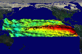
El Nino (October 1992 - June 1997)
A combined perpsective of the El Nino induced change in the sea surface topography as viewed from space by the NASA TOPEX radar altimetry satellite and sea surface temperature observed by NOAA's AVHRR sensor for the month of July 1997. The three dimensional relief map shows a sea level rise along the Equator in the eastern Pacific Ocean of up to 34 centimeters with the red colors indicating an associated change in sea surface temperature of up to 5.4 degrees Celius.A combined perpsective of the the weakening of the Trade Winds across the Pacific Ocean and the associated increase in sea surface temperature during the month of July 1997. The convergence of the surface wind field into the anomalous warm water regions indicates a continued strengthening of this El Nino event.
Images: JPEG (53 k)
Source/Citation: Antonio J. Busalacchi, Laboratory for Hydrospheric Processes, NASA/Goddard Space Flight Center
| Technical notes: | Height data: TOPEX Poseidon Wind data: from ship measurements Sea Surface Temperature: Pathfinder Data Dates: October 1992 - June 1997 Rendered: October 1997 |
For: Toni Busalacchi from Code 970 and Public Affairs Office
