Landsat Thematic Mapper Data of Shanghai
Shanghai
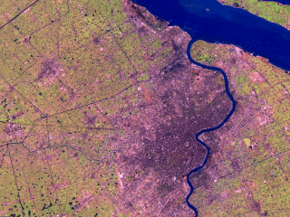
This scene shows the mouth of the Yangtze River in China as seen by the
Landsat Thematic Mapper (TM) instrument. The river running north (up) in
the bottom half of the image is the Huangpu River. The city to the west of
the Huangpu is Shanghai. The shortwave infrared (TM band 5), infrared (TM
band 4), and visible green (TM band 2) channels are displayed in the images
as red, green, and blue respectively. In this combination, barren and/or
recently cultivated land appears red to pink, vegetation appears green,
water is dark blue, and artificial structures of concrete and asphalt appear
dark grey or black.
Technical notes:
Rendered: May, 1998
Data source: Landsat 5 Thematic Mapper
Data date: February 1998
For: Screenscope, Inc.
|