Instrument Aboard NASA's Aqua Satellite Joins Twin to Begin Comprehensive Global CoverageAugust 15, 2002 - (date of web publication)
Image/Animation 1
Roughly 438 miles above the Earth, the Moderate Resolution Imaging Spectroradiometer (MODIS) instrument aboard NASA's Aqua satellite opened its Earth-view door on June 24 and took its first look at our planet. This event, called "first light," marks a milestone in Earth observation, allowing scientists to conduct the most comprehensive daily examination of our planet by combining data from two MODIS instruments on sister satellites in Earth orbit. Like its twin flying aboard NASA's Terra satellite -- launched in 1999 -- Aqua MODIS sees almost the entire surface of our planet every day in 36 channels ranging from visible to thermal infrared wavelengths. On a daily basis, Terra descends across the equator at 10:30 a.m. in every time zone, while Aqua ascends across the equator at 1:30 p.m. in every time zone. The different timing of the satellites' pole-to-pole orbits enables scientists to focus on different aspects of the Earth's climate system and to see changes within the system during the course of a day.
Image 2
"With the launch of Aqua," said MODIS Team Leader Vince Salomonson, of NASA's Goddard Space Flight Center, Greenbelt, Md., "we are able to observe land, ocean and atmosphere phenomena in the afternoon with Aqua and in the morning with Terra. This is especially important for observing rapid, time-varying phenomena like clouds and water vapor." Understanding the processes of water evaporation, the movements of water vapor (the dominant greenhouse gas) throughout the atmosphere -- and the relationship of these processes to cloud formation -- is essential to climate and local weather modeling.
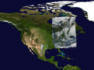
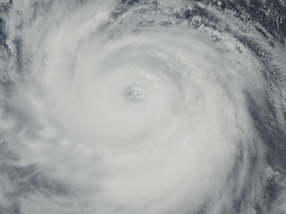
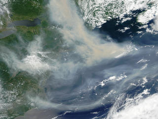
Image 3 In its first day of operations, Aqua MODIS observed significant Earth events occurring all over the globe. Even as Super Typhoon Chataan was rapidly approaching Japan, there was severe flooding in southeast Texas, and a vast, thick pall of smoke from Canadian wildfires blanketed almost the entire U.S. East Coast. MODIS collected and beamed to Earth these images in very-near real time. Data from Aqua MODIS will augment scientists' ability to track wind and clouds in the polar regions where current weather satellites can't see, helping meteorologists to better monitor and predict global weather patterns.
Image 4 Aqua MODIS will also dramatically improve scientists' ability to monitor the daily (diurnal) cycles of the large-scale burning of plant biomass in regions all across the planet. "Aqua MODIS will complement Terra, providing four observations per day that will better sample the daily cycle of fire activity and provide increased opportunity of cloud-free observations," said Chris Justice, the MODIS Land Team Leader at the University of Maryland, College Park. Using Aqua MODIS, scientists can gather more data on how fast and in which direction fires are spreading, as well as how severely a given fire may affect air quality of downwind urban areas.
Image 5 Aqua MODIS data have worldwide applications. The MODIS team is working with the Global Observation of Forest Cover/Gold-Fire Program and the World Fire Monitoring Center to provide fire data to the international community. Team members collaborate with fire monitoring groups in Australia, Botswana, Brazil, Malaysia, Mexico and Russia. Having a second MODIS instrument will also improve ocean-based research. "Aqua will provide continuity of important observations of sea surface temperature and ocean color, which is a marker of the biochemistry of marine organisms," Salomonson added.
Image 6
Aqua and Terra each carry a MODIS instrument designed to gather planetary data across 36 spectral bands. Data will be processed into 44 distinct data products available to the world for use in tracking global climate change. The satellites are part of NASA's Earth Science Enterprise, a long-term research effort to understand and protect our home planet. Through the study of the Earth, NASA will help provide sound science to policy and economic decision-makers to improve life here, while developing the technologies needed to explore the universe and search for life beyond our home planet. For more information contact:
Elvia Thompson Lynn
Chandler Caption for Image 1: THE FIRST DAY IN THE LIFE OF AQUA MODIS - In its first day of operations, June 24, 2002, Aqua MODIS observed significant Earth events occurring all over the globe. As Super Typhoon Chataan was rapidly approaching Japan, there was severe flooding in southeast Texas and a vast, thick pall of smoke from Canadian wildfires blanketed almost the entire U.S. east coast. MODIS collected and beamed to Earth these images in very near real-time. Caption for Image 2:
FLOODING IN SOUTHEAST TEXAS - Southeast of San Antonio,
Texas, rivers that were barely discernible in satellite imagery acquired in late
June 2002 by Terra MODIS stand out clearly this Aqua MODIS image from July 7,
2002. Heavy rains during the first week of July brought as much as 2 feet of rain
to some places in southeastern Texas, resulting in massive flooding of three major
river systems along the Gulf of Mexico. In this false-color image, rivers and
standing water appear dark blue or black against the green and brown landscape.
The animation takes the viewer from the June 2002 Terra MODIS image to the July
7 MODIS image.
Caption for Image 3:
SUPER TYPHOON CHATAAN IMAGE - Caption for Image 4: SMOKE FROM CANADIAN WILDFIRES IMAGE - Smoke from multiple large wildfires in Québec, Canada, drifted far to the south of the border, as seen in this Moderate Resolution Imaging Spectroradiometer (Aqua MODIS) image from July 7, 2002. Active fire detections are indicated with red dots. The Canadian Interagency Forest Fire Center reported there were seven out-of-control fires burning south of James Bay (the southern extension of Hudson Bay, seen at upper left in the image), all probably the result of lightning. High Resolution of Image 4
Caption for Image 5:
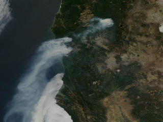
SMOKE FROM OREGON FIRES - Caption for Image 6:
AQUA SPACECRAFT ANIMATION - All images and animations courtesy: NASA |