Previous Tape   Next Tape

Goddard TV Video Tape: G2011-062 -- Mississippi River 2011 Flooding


Movie

Title

Satellite imagery of the 2011 flooding along the Mississippi River compared with imagery from 2010.  Shows high resolution images from Landsat 5 of Cairo, Illinois, and Memphis, Tennessee.   To prevent flooding in Cairo, Illinois, the US Army Corps of Engineers blasted a two-mile hole in the levee to let the waters flow into the New Madrid Floodway.  Near Memphis Tennessee, flood waters crested at 48 feet, only inches below the record high level of the 1937 floods.  No narration, just music. 
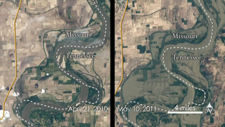
Mississippi Flooding 2011