Earth
ID: 4913
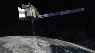
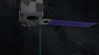
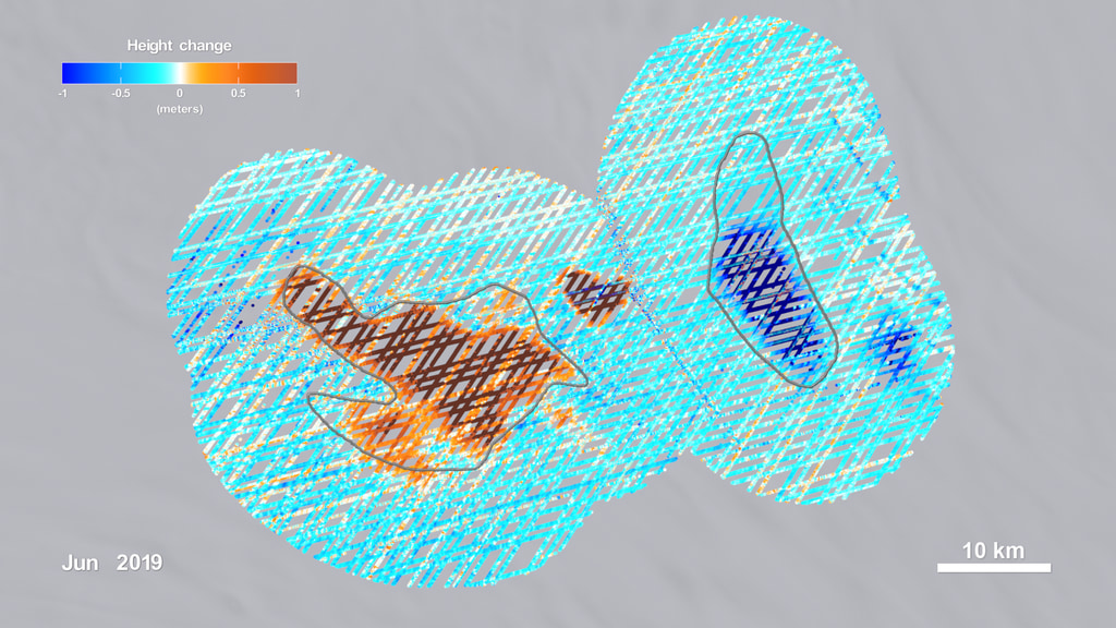
NASA’s Ice, Cloud and land Elevation Satellite 2, or ICESat-2 dense laser altimetry data allowed scientists for the first-time to precisely map subglacial lakes in Antarctica. NASA’s ICESat-2 measures the height of the ice surface, which, despite its enormous thickness, rises or falls as lakes fill or empty under the ice sheet. In the study, titled Illuminating Active Subglacial Lake Processes With ICESat-2 Laser Altimetry, published in Geophysical Research Letters, researchers Matthew Siegfried et al. integrated height data from NASA’s ICESat-2 mission, its predecessor ICESat, as well as from CryosSat-2 from the European Space Agency. The published findings provide critical insight for spotting new subglacial lakes from space and a better understanding of their drain and fill cycles. Furthermore, the findings increase our knowledge on how outlines or boundaries of lakes change gradually as water enters and leaves the reservoirs.
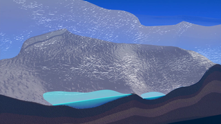
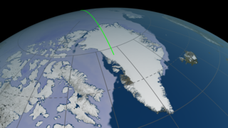
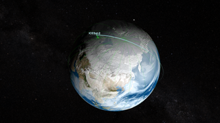
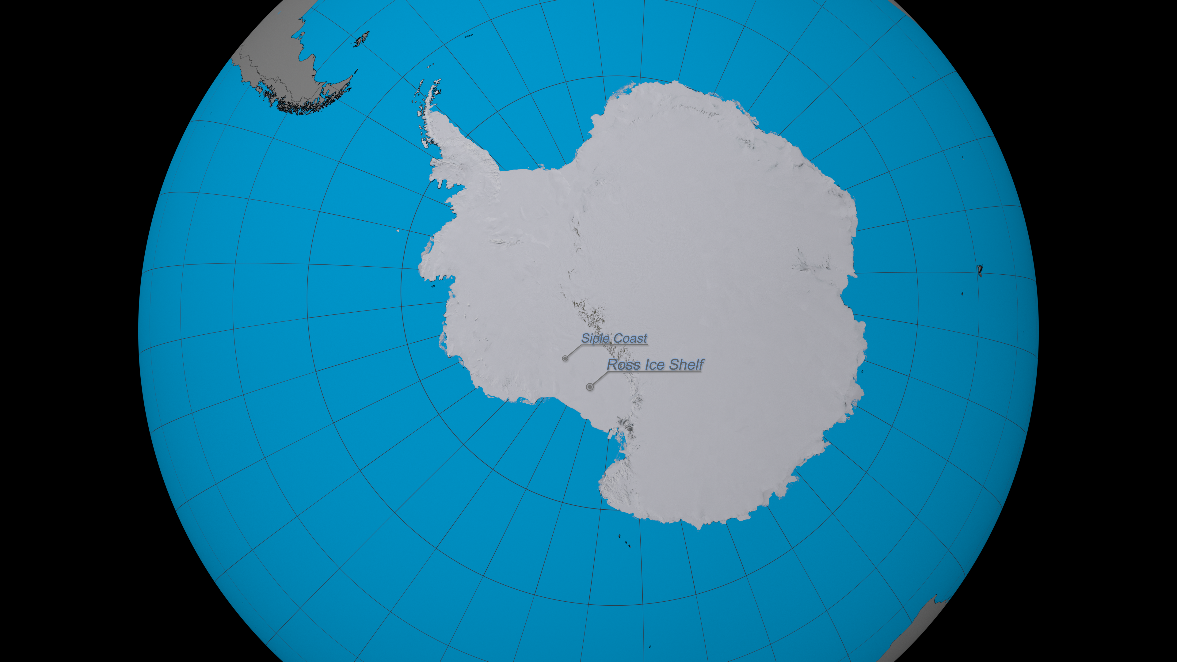
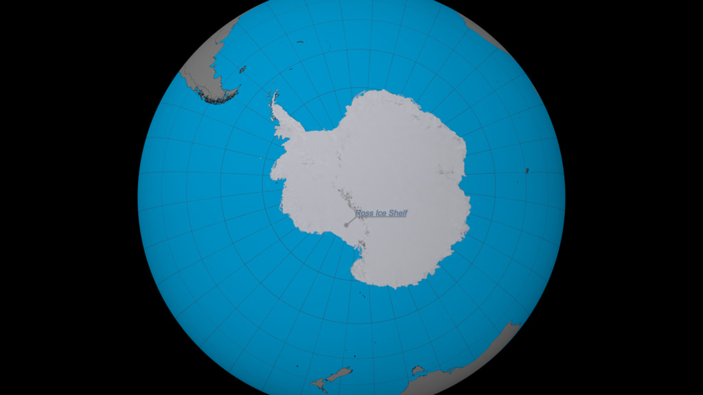
The data visualization sequence starts with a view of the Americas from space and slowly zooms into the continent of Antarctica. During the gradual zoom labels indicate ice formations of high relevance in West Antarctica, such as Ross Ice Shelf, Siple Coast, Mercer Ice Stream, Whillans Ice Stream and finally Conway Subglacial Lake and Mercer Subglacial Lake. The Conway and Mercer subglacial lakes are located near the suture between Mercer and Whillans ice streams – one of the most studied active subglacial regions in Antarctica. After the final zoom stage surface-height anomaly data reveal changes in the study area of Lake Conway and Lake Mercer for the period of September 2018-June 2020.
The data sequence shows the connected fill-drain cycle of Conway and Mercer subglacial lakes. For example by May 2019, we can see how water drained from Lake Conway to Lake Mercer, where the area within the outlines of Conway subglacial lake is mostly brown-ish and the area within the outlines of Mercer subglacial lake is mostly blue-ish. In addition, we can see that by January 2020 the opposite shift has occurred, where water from Lake Mercer drained to Lake Conway. During the sequence, we can also detect the formation of two new smaller lakes, adjacent to the Conway and Mercer subglacial lakes. These two new lakes are called: Lower Conway Subglacial Lake, which is located between Lake Conway and Lake Mercer and Lower Mercer Subglacial Lake, which is located south of Mercer subglacial lake.
The data visualization content featured on this page contains distinct versions for 4K and HD resolutions. Please select the appropriate version for the native resolution of your screen.
Data Sources:
The rest of this webpage offers additional versions, frames, layers and colorbar information, associated with the development of this data-driven visualization.


ICESat-2 Maps Subglacial Lakes in Antarctica
NASA’s Ice, Cloud and land Elevation Satellite 2, or ICESat-2 dense laser altimetry data allowed scientists for the first-time to precisely map subglacial lakes in Antarctica. NASA’s ICESat-2 measures the height of the ice surface, which, despite its enormous thickness, rises or falls as lakes fill or empty under the ice sheet. In the study, titled Illuminating Active Subglacial Lake Processes With ICESat-2 Laser Altimetry, published in Geophysical Research Letters, researchers Matthew Siegfried et al. integrated height data from NASA’s ICESat-2 mission, its predecessor ICESat, as well as from CryosSat-2 from the European Space Agency. The published findings provide critical insight for spotting new subglacial lakes from space and a better understanding of their drain and fill cycles. Furthermore, the findings increase our knowledge on how outlines or boundaries of lakes change gradually as water enters and leaves the reservoirs.
The data visualization sequence starts with a view of the Americas from space and slowly zooms into the continent of Antarctica. During the gradual zoom labels indicate ice formations of high relevance in West Antarctica, such as Ross Ice Shelf, Siple Coast, Mercer Ice Stream, Whillans Ice Stream and finally Conway Subglacial Lake and Mercer Subglacial Lake. The Conway and Mercer subglacial lakes are located near the suture between Mercer and Whillans ice streams – one of the most studied active subglacial regions in Antarctica. After the final zoom stage surface-height anomaly data reveal changes in the study area of Lake Conway and Lake Mercer for the period of September 2018-June 2020.
The data sequence shows the connected fill-drain cycle of Conway and Mercer subglacial lakes. For example by May 2019, we can see how water drained from Lake Conway to Lake Mercer, where the area within the outlines of Conway subglacial lake is mostly brown-ish and the area within the outlines of Mercer subglacial lake is mostly blue-ish. In addition, we can see that by January 2020 the opposite shift has occurred, where water from Lake Mercer drained to Lake Conway. During the sequence, we can also detect the formation of two new smaller lakes, adjacent to the Conway and Mercer subglacial lakes. These two new lakes are called: Lower Conway Subglacial Lake, which is located between Lake Conway and Lake Mercer and Lower Mercer Subglacial Lake, which is located south of Mercer subglacial lake.
The data visualization content featured on this page contains distinct versions for 4K and HD resolutions. Please select the appropriate version for the native resolution of your screen.
Data Sources:
- Conway Subglacial Lake and Mercer Subglacial Lake Spatial Height Anomalies for the period 09/2018-05/2020, derived from the ATLAS/ICESat-2 L3A Land Ice Height V003 data set. This data set (ATL06) provides geolocated, land-ice surface heights (above the WGS 84 ellipsoid, ITRF2014 reference frame), plus ancillary parameters that can be used to interpret and assess the quality of the height estimates. The data were acquired by the Advanced Topographic Laser Altimeter System (ATLAS) instrument on board the Ice, Cloud and land Elevation Satellite-2 (ICESat-2) observatory.
Citation: ATLAS/ICESat-2 L3A Land Ice Height V003. Version 003. Archived by National Aeronautics and Space Administration, U.S. Government, NASA National Snow and Ice Data Center Distributed Active Archive Center. doi: https://doi.org/10.5067/ATLAS/ATL06.003 [Date Accessed: July 14, 2021]
Matthew R. Siegfried. (2021, June 8). mrsiegfried/Siegfried2021-GRL: Initial release with acceptance (Version 1.0). Zenodo. doi: https://doi.org/10.5281/zenodo.4914107 - Outlines of Conway and Mercer subglacial lakes, derived by ICESat mission. The outlines were provided by the science team and are available here: https://github.com/mrsiegfried/Siegfried2021-GRL/tree/main/data/outlines [Date Accessed: July 27, 2021]
- New Landsat Image Mosaic of Antarctica (LIMA) Product, Center-Filled LIMA, complete contintent created by the Landsat Image Mosaic of Antarctica (LIMA) Project. The Center-Filled LIMA product is a seamless and virtually cloudless mosaic created from processed Landsat 7 ETM+ scenes. In areas where Landsat had no coverage imagery from the Moderate Resolution Imaging Spectroradiometer (MODIS) Mosaic of Antarctica (MOA) was used. The visualizations featured on this page utilize the New LIMA product as the Antarctica texture throughout the sequences. doi: https://doi.org/10.5066/P9TEIU3H
The dataset is available at: https://lima.usgs.gov [Date Accessed: June 14, 2021].
Citation: Bindschadler, R., Vornberger, P., Fleming, A., Fox, A., Mullins, J., Binnie, D., Paulson, S., Granneman, B., and Gorodetzky, D., 2008, The Landsat Image Mosaic of Antarctica, Remote Sensing of Environment, 112, pp. 4214-4226. doi: https://doi.org/10.1016/j.rse.2008.07.006 - Blue Marble: Next Generation was produced by Reto Stöckli, NASA Earth Observatory (NASA Goddard Space Flight Center). Citation: Reto Stöckli, Eric Vermote, Nazmi Saleous, Robert Simmon and David Herring.
The Blue Marble Next Generation – A true color earth dataset including seasonal dynamics from MODIS, October 17, 2005. The visualizations on this page utilize Blue Marble data to map the water and land bodies around the globe.
The rest of this webpage offers additional versions, frames, layers and colorbar information, associated with the development of this data-driven visualization.
Used Elsewhere In
Related
For More Information
Visualization Credits
Helen-Nicole Kostis (USRA): Lead Visualizer
Greg Shirah (NASA/GSFC): Lead Visualizer
Matthew R. Siegfried (Colorado School of Mines): Lead Scientist
Helen Amanda Fricker (Scripps Institution of Oceanography, University of California, San Diego): Lead Scientist
Jefferson Beck (KBR Wyle Services, LLC): Lead Producer
Roberto Molar Candanosa (KBR): Writer
Laurence Schuler (ADNET Systems, Inc.): Technical Support
Ian Jones (ADNET Systems, Inc.): Technical Support
Please give credit for this item to:
NASA's Scientific Visualization Studio
NASA's Scientific Visualization Studio
Science Paper:
Siegfried, M. R., & Fricker, H. A. (2021). Illuminating active subglacial lake processes with ICESat-2 laser altimetry. Geophysical Research Letters, 48, e2020GL091089. doi: 10.1029/2020GL091089
Short URL to share this page:
https://svs.gsfc.nasa.gov/4913
Mission:
Ice, Cloud, and land Elevation Satellite-2 (ICESat-2)
Data Used:
Note: While we identify the data sets used in these visualizations, we do not store any further details nor the data sets themselves on our site.
Keywords:
SVS >> Antarctic
SVS >> Climate
DLESE >> Hydrology
SVS >> Ice Sheets
SVS >> Lake
GCMD >> Location >> Antarctica
SVS >> Hyperwall
NASA Science >> Earth
GCMD >> Earth Science >> Terrestrial Hydrosphere >> Glaciers/Ice Sheets >> Ice Sheets
SVS >> ICESat-2
NASA Earth Science Focus Areas >> Climate Variability and Change
NASA Earth Science Focus Areas >> Water and Energy Cycle
SVS >> Subglacial Lakes
GCMD keywords can be found on the Internet with the following citation: Olsen, L.M., G. Major, K. Shein, J. Scialdone, S. Ritz, T. Stevens, M. Morahan, A. Aleman, R. Vogel, S. Leicester, H. Weir, M. Meaux, S. Grebas, C.Solomon, M. Holland, T. Northcutt, R. A. Restrepo, R. Bilodeau, 2013. NASA/Global Change Master Directory (GCMD) Earth Science Keywords. Version 8.0.0.0.0
Siegfried, M. R., & Fricker, H. A. (2021). Illuminating active subglacial lake processes with ICESat-2 laser altimetry. Geophysical Research Letters, 48, e2020GL091089. doi: 10.1029/2020GL091089
Short URL to share this page:
https://svs.gsfc.nasa.gov/4913
Mission:
Ice, Cloud, and land Elevation Satellite-2 (ICESat-2)
Data Used:
Terra and Aqua/MODIS/Blue Marble: Next Generation also referred to as: BMNG
Credit:
The Blue Marble data is courtesy of Reto Stockli (NASA/GSFC).
The Blue Marble data is courtesy of Reto Stockli (NASA/GSFC).
New Landsat Image Mosaic of Antarctica (LIMA) Product also referred to as: New LIMA Product
Mosaic
The Center-Filled LIMA product is a seamless and virtually cloudless mosaic created from processed Landsat 7 ETM+ scenes. In areas where Landsat had no coverage imagery from the Moderate Resolution Imaging Spectroradiometer (MODIS) Mosaic of Antarctica (MOA) was used. doi: https://doi.org/10.5066/P9TEIU3H
Credit:
Landsat Image Mosaic of Antarctica (LIMA) Project, NASA/GSFC, British Antarctic Survey, USGS
Landsat Image Mosaic of Antarctica (LIMA) Project, NASA/GSFC, British Antarctic Survey, USGS
ATLAS/ICESat-2 L3A Land Ice Height V003 also referred to as: ATL06
Observed Data
ATL06 provides geolocated, land-ice surface heights (above the WGS 84 ellipsoid, ITRF2014 reference frame), plus ancillary parameters that can be used to interpret and assess the quality of the height estimates. The data were acquired by the Advanced Topographic Laser Altimeter System (ATLAS) instrument on board the Ice, Cloud and land Elevation Satellite-2 (ICESat-2) observatory.
Credit:
Archived by National Aeronautics and Space Administration, U.S. Government, NASA National Snow and Ice Data Center Distributed Active Archive Center.
Archived by National Aeronautics and Space Administration, U.S. Government, NASA National Snow and Ice Data Center Distributed Active Archive Center.
Outlines of Conway and Mercer Suglacial Lakes
Keywords:
SVS >> Antarctic
SVS >> Climate
DLESE >> Hydrology
SVS >> Ice Sheets
SVS >> Lake
GCMD >> Location >> Antarctica
SVS >> Hyperwall
NASA Science >> Earth
GCMD >> Earth Science >> Terrestrial Hydrosphere >> Glaciers/Ice Sheets >> Ice Sheets
SVS >> ICESat-2
NASA Earth Science Focus Areas >> Climate Variability and Change
NASA Earth Science Focus Areas >> Water and Energy Cycle
SVS >> Subglacial Lakes
GCMD keywords can be found on the Internet with the following citation: Olsen, L.M., G. Major, K. Shein, J. Scialdone, S. Ritz, T. Stevens, M. Morahan, A. Aleman, R. Vogel, S. Leicester, H. Weir, M. Meaux, S. Grebas, C.Solomon, M. Holland, T. Northcutt, R. A. Restrepo, R. Bilodeau, 2013. NASA/Global Change Master Directory (GCMD) Earth Science Keywords. Version 8.0.0.0.0


