Earth
ID: 4880
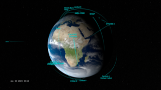
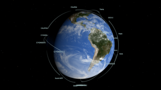
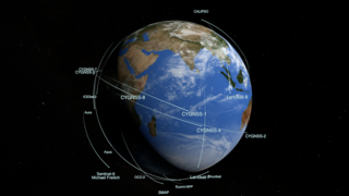
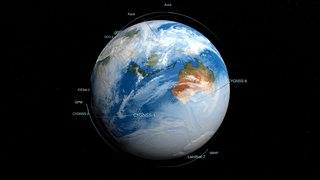
This animation shows the orbits of satellites that NASA is using to study the impact of the COVID-19 pandemic on the environment. It includes assets from our domestic partners, such as the National Oceanic and Atmospheric Administration (NOAA) and the U.S. Geological Survey, our international partners, such as the European Space Agency (ESA) and the Japan Aerospace Exploration Agency (JAXA), and our commercial partner Planet Labs.
Together, our combined measurements are providing the spatial and temporal breadth to more fully characterize and understand how society’s changing behavior during the pandemic is affecting the Earth system.
The clouds used in this version are from a high resolution GEOS model run at 10 minute time steps interpolated down to the per-frame level.
Spacecraft included:
NASA
Aqua
Aura
Suomi NPP: Suomi National Polar-orbiting Partnership
OCO-2: Orbiting Carbon Observatory-2
Terra
Landsat 7
Landsat 8
ISS: International Space Station
International
Sentinel-1
Sentinel-2
Sentinel-5P
GOSAT
ALOS-2
Commercial
Planet Labs 178 nanosatellites
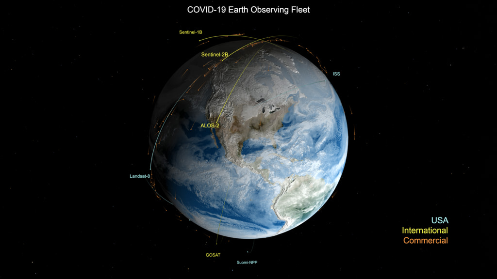
COVID-19 Earth Observing Fleet
Together, our combined measurements are providing the spatial and temporal breadth to more fully characterize and understand how society’s changing behavior during the pandemic is affecting the Earth system.
The clouds used in this version are from a high resolution GEOS model run at 10 minute time steps interpolated down to the per-frame level.
Spacecraft included:
NASA
Aqua
Aura
Suomi NPP: Suomi National Polar-orbiting Partnership
OCO-2: Orbiting Carbon Observatory-2
Terra
Landsat 7
Landsat 8
ISS: International Space Station
International
Sentinel-1
Sentinel-2
Sentinel-5P
GOSAT
ALOS-2
Commercial
Planet Labs 178 nanosatellites
Used Elsewhere In
Related
Visualization Credits
Kel Elkins (USRA): Lead Visualizer
Greg Shirah (NASA/GSFC): Visualizer
Lori Perkins (NASA/GSFC): Technical Support
Kevin J. Murphy (NASA/HQ): Scientific Data Support
Abigail Seadler (GST): Communications Specialist
Greg Shirah (NASA/GSFC): Visualizer
Lori Perkins (NASA/GSFC): Technical Support
Kevin J. Murphy (NASA/HQ): Scientific Data Support
Abigail Seadler (GST): Communications Specialist
Please give credit for this item to:
NASA's Scientific Visualization Studio
NASA's Scientific Visualization Studio
Short URL to share this page:
https://svs.gsfc.nasa.gov/4880
Data Used:
Note: While we identify the data sets used in these visualizations, we do not store any further details nor the data sets themselves on our site.
Keywords:
SVS >> Orbit
SVS >> Hyperwall
NASA Science >> Earth
SVS >> Fleet
https://svs.gsfc.nasa.gov/4880
Data Used:
CelesTrak Spacecraft Orbit Ephemeris
Ephemeris - 11/2020Terra and Aqua/MODIS/Blue Marble: Next Generation also referred to as: BMNG
Credit:
The Blue Marble data is courtesy of Reto Stockli (NASA/GSFC).
The Blue Marble data is courtesy of Reto Stockli (NASA/GSFC).
GEOS Atmospheric Model
Model - NASA GMAOKeywords:
SVS >> Orbit
SVS >> Hyperwall
NASA Science >> Earth
SVS >> Fleet


