Earth
ID: 4773
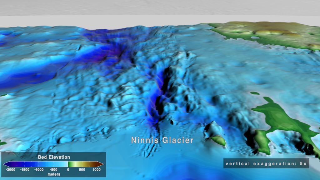
BedMachine is a new Antarctic bed topography product based on ice thickness data from 19 different research institutes dating back to 1967, encompassing nearly a million line-miles of radar soundings. BedMachine relies on the fundamental physics-based method of mass conservation to estimate what lies between the radar sounding lines, utilizing highly detailed information on ice flow motion from satellite data that dictates how ice moves. The dataset is available from the National Snow & Ice Data Center here.
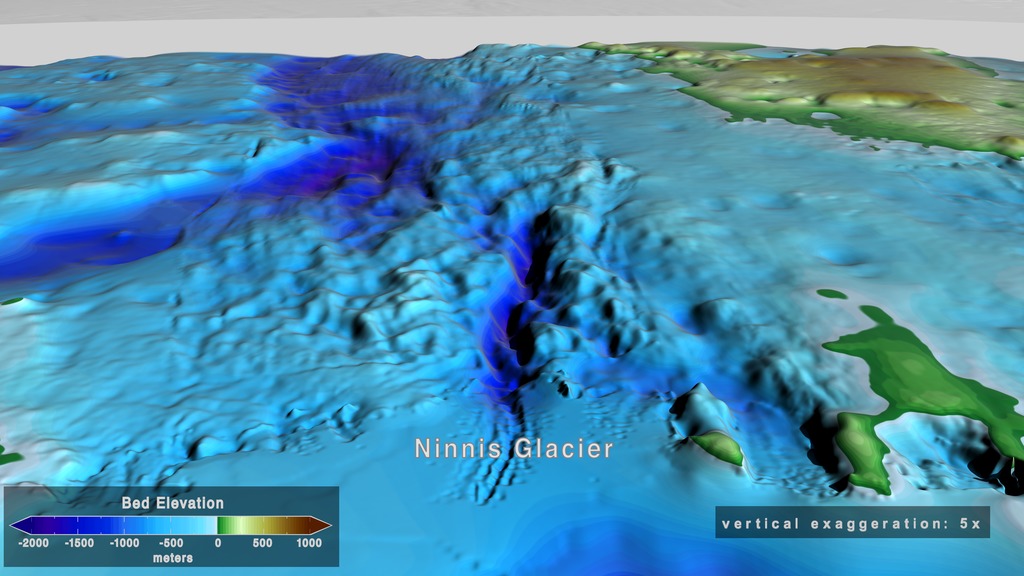
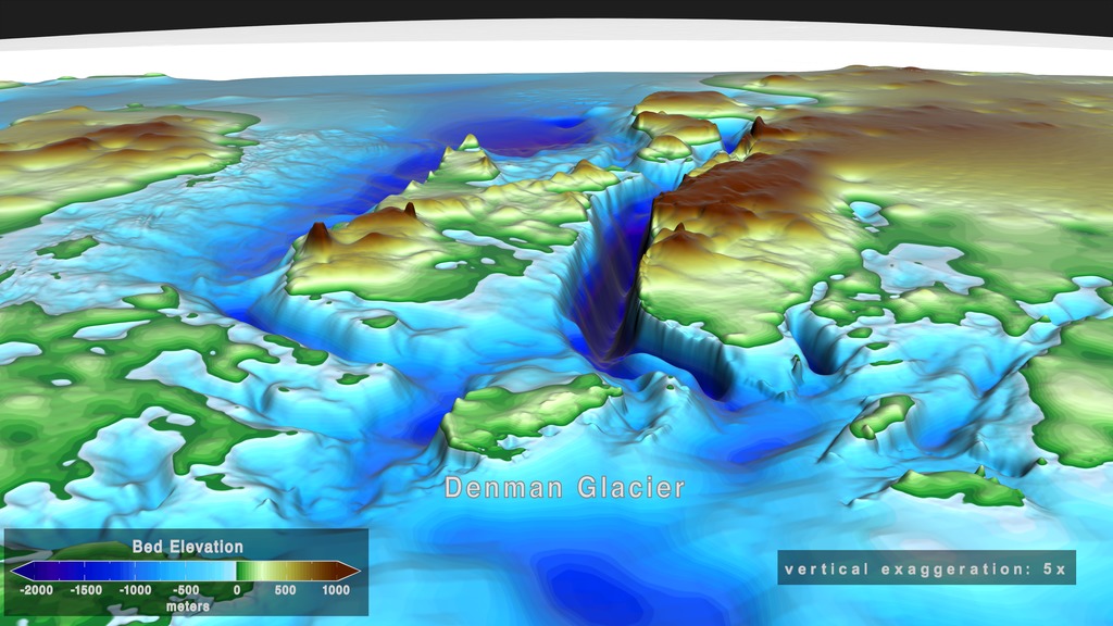
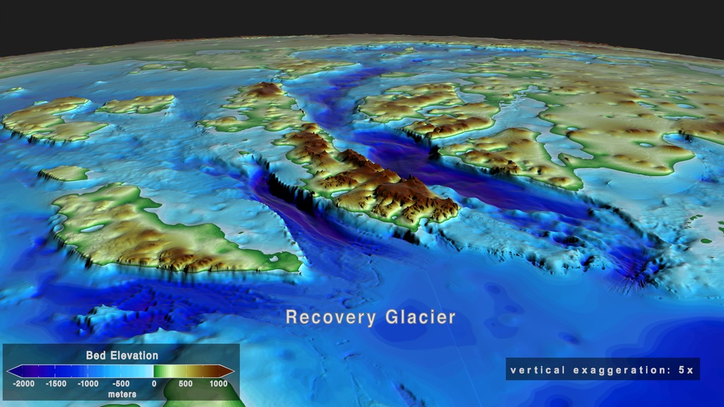
BedMachine: A high-precision map of Antarctic ice sheet bed topography
Visualization Credits
Lead Visualizer:
Cindy Starr (Global Science and Technology, Inc.)
Visualizer:
Greg Shirah (NASA/GSFC)
Scientists:
Mathieu Morlighem (University of California, Irvine)
Eric J. Rignot (NASA/JPL CalTech)
Tobias Binder (Alfred Wegener Institute Helmholtz Centre for Polar and Marine Research)
Donald D. Blankenship (Institute for Geophysics, University of Texas at Austin)
Reinhard Drews (University of Tübingen)
Graeme Eagles (Alfred Wegener Institute Helmholtz Centre for Polar and Marine Research)
Olaf Eisen (Alfred Wegener Institute Helmholtz Centre for Polar and Marine Research/University of Bremen)
Fausto Ferraccioli (British Antarctic Survey)
Rene Forsberg (Technical University of Denmark)
Peter Fretwell (British Antarctic Survey)
Vikram Goel (National Centre for Polar and Ocean Research, India)
Jamin S. Greenbaum (University of Texas at Austin)
Hilmar Gudmundsson (Northumbria University)
Jingxue Gu (Polar Research Institute of China)
Veit Helm (Alfred Wegener Institute Helmholtz Centre for Polar and Marine Research)
Coen Hofstede (Alfred Wegener Institute Helmholtz Centre for Polar and Marine Research)
Ian Howat (Ohio State University)
Angelika Humbert (Alfred Wegener Institute Helmholtz Centre for Polar and Marine Research/University of Bremen)
Wilfried Jokat (Alfred Wegener Institute)
Nanna B. Karlsson (Alfred Wegener Institute Helmholtz Centre for Polar and Marine Research/University of Bremen)
Kenichi Matsuoka (Norwegian Polar Institute)
Romain Millan (University of California, Irvine)
Jeremie Mouginot (University of California, Irvine)
John Paden (University of Kansas)
Frank Pattyn (Université libre de Bruxelles)
Jasen Roberts (Australian Antarctic Division/Antarctic Climate & Ecosystems Cooperative Research Centre/Institute for Marine and Antarctic Studies, University of Tasmania)
Sebastian Rosier (Northumbria University)
Antonia Ruppel (Federal Institute for Geosciences and Natural Resources, Germany)
Helene Seroussi (NASA/JPL CalTech)
Emma C. Smith (Alfred Wegener Institute Helmholtz Centre for Polar and Marine Research)
Daniel Steinhage (Alfred Wegener Institute)
Won Sang Lee (Korea Polar Research Institute, South Korea)
Bo Sun (Polar Research Institute of China)
Michiel R. van den Broeke (Utrecht University)
Tas D. Van Ommen (Australian Antarctic Division/Antarctic Climate & Ecosystems Cooperative Research Centre/Institute for Marine and Antarctic Studies, University of Tasmania)
Duncan A. Young (Institute for Geophysics, University of Texas)
Melchior Van Wessem (Utrecht University)
Project Support:
Leann Johnson (Global Science and Technology, Inc.)
Wei Hao (GST)
Technical Support:
Ian Jones (ADNET Systems, Inc.)
Laurence Schuler (ADNET Systems, Inc.)
Please give credit for this item to:
NASA's Scientific Visualization Studio
NASA's Scientific Visualization Studio
Science Paper:
Morlighem M. et al., (2019), Deep glacial troughs and stabilizing ridges unveiled beneath the margins of the Antarctic ice sheet, Nature Geoscience, doi: 10.1038/s41561-019-0510-8 ( https://doi.org/10.1038/s41561-019-0510-8 )
Short URL to share this page:
https://svs.gsfc.nasa.gov/4773
Data Used:
Note: While we identify the data sets used in these visualizations, we do not store any further details nor the data sets themselves on our site.
Keywords:
SVS >> Antarctic
SVS >> Antarctic Ice Sheet
DLESE >> Physical geography
GCMD >> Earth Science >> Land Surface >> Topography
GCMD >> Earth Science >> Cryosphere >> Glaciers/Ice Sheets >> Ice Sheets
GCMD >> Earth Science >> Hydrosphere >> Glaciers/Ice Sheets >> Ice Sheets
GCMD >> Earth Science >> Land Surface >> Topography >> Topographical Relief
SVS >> Hyperwall
SVS >> Antarctica >> Topography
NASA Science >> Earth
GCMD >> Earth Science >> Terrestrial Hydrosphere >> Glaciers/Ice Sheets >> Ice Sheets
GCMD keywords can be found on the Internet with the following citation: Olsen, L.M., G. Major, K. Shein, J. Scialdone, S. Ritz, T. Stevens, M. Morahan, A. Aleman, R. Vogel, S. Leicester, H. Weir, M. Meaux, S. Grebas, C.Solomon, M. Holland, T. Northcutt, R. A. Restrepo, R. Bilodeau, 2013. NASA/Global Change Master Directory (GCMD) Earth Science Keywords. Version 8.0.0.0.0
Morlighem M. et al., (2019), Deep glacial troughs and stabilizing ridges unveiled beneath the margins of the Antarctic ice sheet, Nature Geoscience, doi: 10.1038/s41561-019-0510-8 ( https://doi.org/10.1038/s41561-019-0510-8 )
Short URL to share this page:
https://svs.gsfc.nasa.gov/4773
Data Used:
Terra and Aqua/MODIS/Blue Marble: Next Generation also referred to as: BMNG
Credit:
The Blue Marble data is courtesy of Reto Stockli (NASA/GSFC).
The Blue Marble data is courtesy of Reto Stockli (NASA/GSFC).
MEaSUREs BedMachine Antarctica
Data Compilation - NASA
Part of the NASA Making Earth System Data Records for Use in Research Environments (MEaSUREs) program, contains a bed topography/bathymetry map of Antarctica based on mass conservation, streamline diffusion, and other methods. The data set also includes ice thickness, surface elevation, an ice/ocean/land mask, ice thickness estimation errors, and a map showing where each method was utilized.
Keywords:
SVS >> Antarctic
SVS >> Antarctic Ice Sheet
DLESE >> Physical geography
GCMD >> Earth Science >> Land Surface >> Topography
GCMD >> Earth Science >> Cryosphere >> Glaciers/Ice Sheets >> Ice Sheets
GCMD >> Earth Science >> Hydrosphere >> Glaciers/Ice Sheets >> Ice Sheets
GCMD >> Earth Science >> Land Surface >> Topography >> Topographical Relief
SVS >> Hyperwall
SVS >> Antarctica >> Topography
NASA Science >> Earth
GCMD >> Earth Science >> Terrestrial Hydrosphere >> Glaciers/Ice Sheets >> Ice Sheets
GCMD keywords can be found on the Internet with the following citation: Olsen, L.M., G. Major, K. Shein, J. Scialdone, S. Ritz, T. Stevens, M. Morahan, A. Aleman, R. Vogel, S. Leicester, H. Weir, M. Meaux, S. Grebas, C.Solomon, M. Holland, T. Northcutt, R. A. Restrepo, R. Bilodeau, 2013. NASA/Global Change Master Directory (GCMD) Earth Science Keywords. Version 8.0.0.0.0


