Earth
ID: 4634
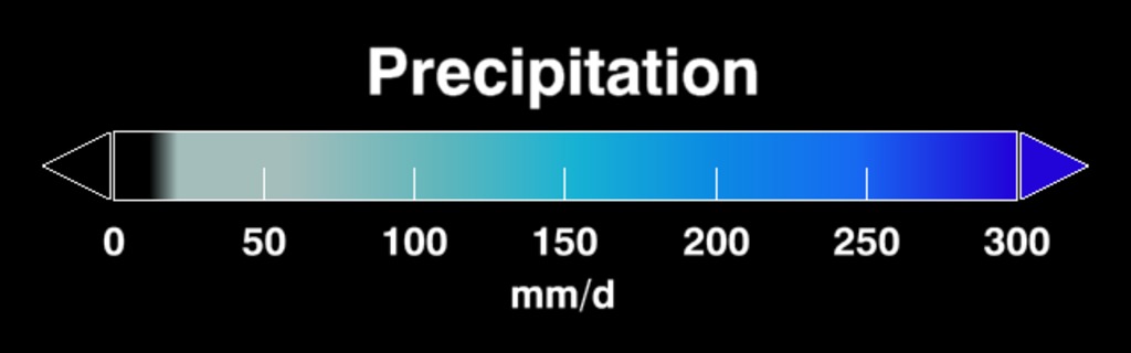
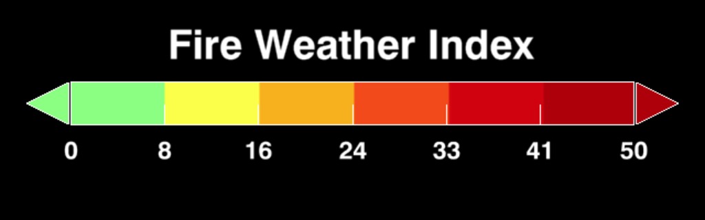
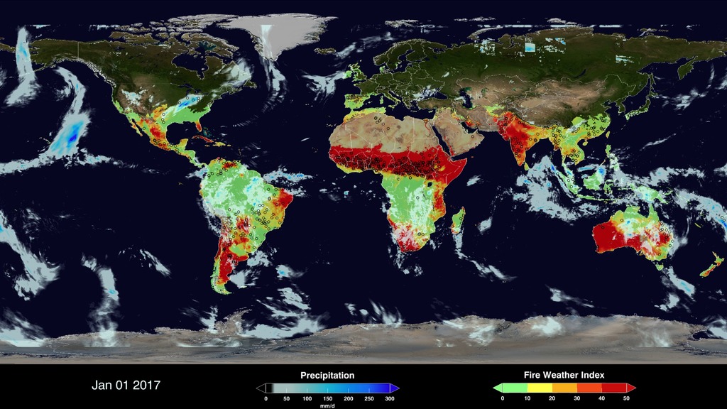
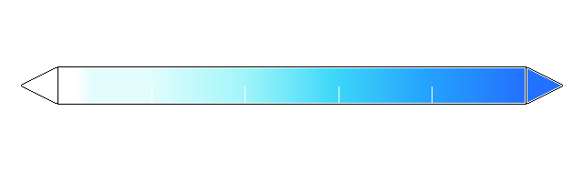
The Global Fire WEather Database (GFWED) integrates different weather factors influencing the likelihood of a vegetation fire starting and spreading. It is based on the Fire Weather Index (FWI) System, which tracks the dryness of three general fuel classes, and the potential behavior of a fire if it were to start. Each day, FWI values are calculated from global weather data, including satellite rainfall data from the Global Precipitation Measurement (GPM) mission.
The FWI System is the most widely used fire danger rating system in the world, and has been adopted for different boreal, temperate and tropical fire environments. GFWED provides a globally consistent fire weather dataset for fire researchers and managers to apply locally.
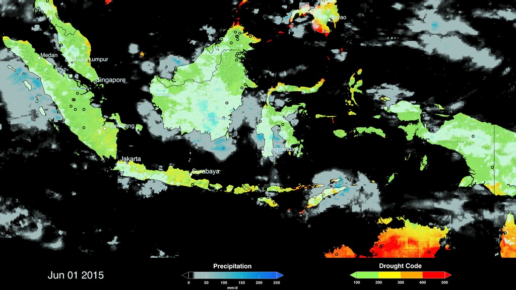
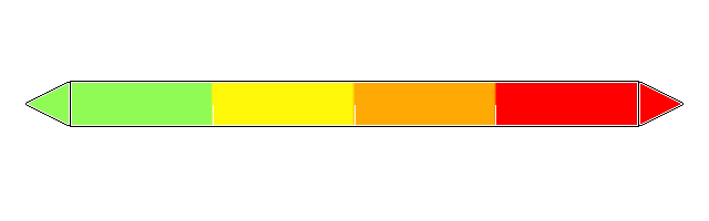
The Fire Weather Index component is suitable as a general index of fire danger. Globally, shifts in continental-scale fire activity follow seasonal changes in the FWI. Over South America and Africa, regions of high FWI and active agricultural burning shift with the tropical rain belts, seen in the GPM precipitation overlay. Over North America and Eurasia, the FWI will ‘activate’ in the spring, and shows how week-to-week surges in fire activity can be driven by high FWI values.
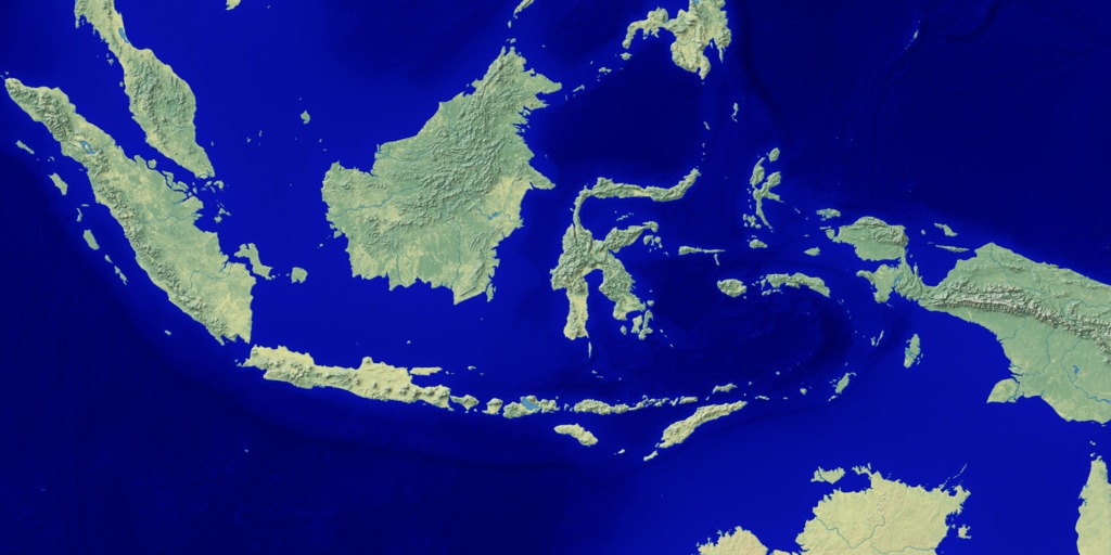
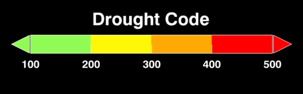
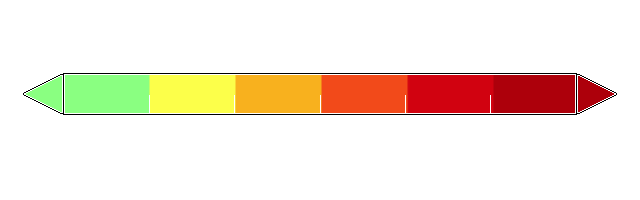
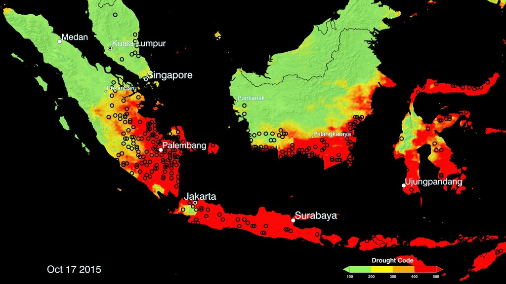
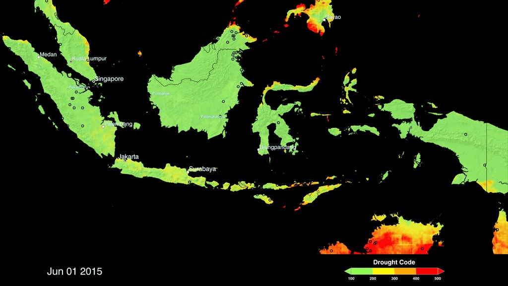
In Indonesia, the Drought Code (DC) component is used to track the potential for agricultural fires to escape underground into peat soils, where they cannot be extinguished until the return of the monsoon rains. From August to October, areas of concentrated fire activity and high DC caused continuous smoke emissions and hazardously poor air quality until the return of the monsoon rains in November. Scientists are working with the Indonesian Agency for Meteorology, Climatology and Geophysics and the Ministry of Environment and Forestry to augment their operational FWI system with GPM precipitation.

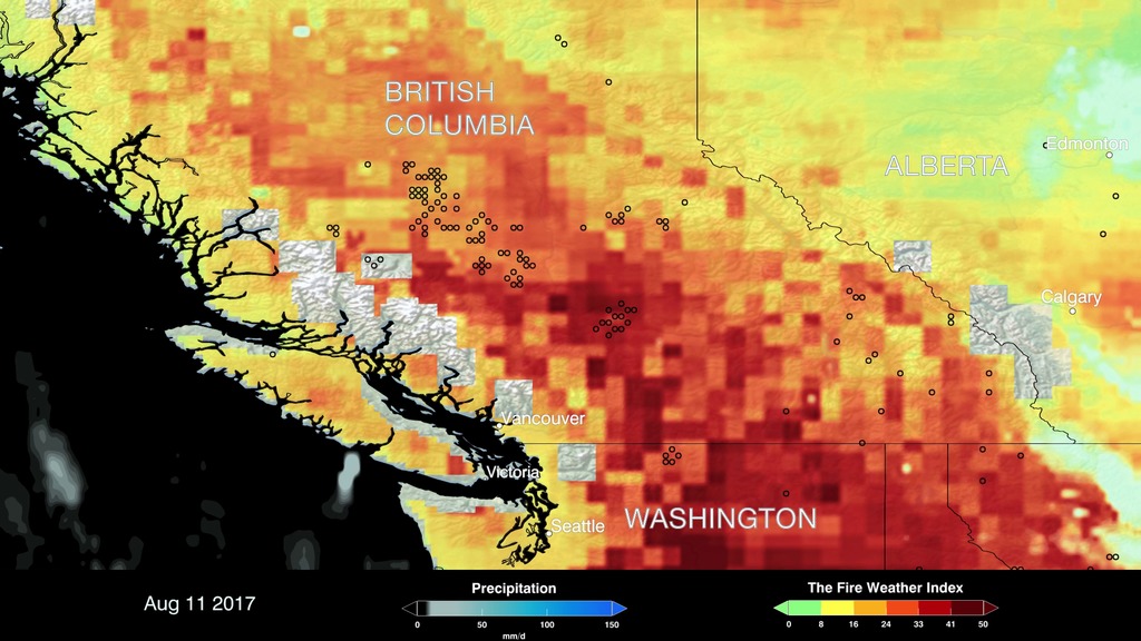
In British Columbia, Canada, 2017 was a severe fire year, where the FWI is used for fire prevention and pre-preparedness. Through July and August, stretches of high FWI in the interior led to periods of extreme fire behavior and the highest annual recorded burned area for the province.

More information on GFWED and instructions on accessing the data are available from https://data.giss.nasa.gov/impacts/gfwed/
Global Fire Weather Database
The FWI System is the most widely used fire danger rating system in the world, and has been adopted for different boreal, temperate and tropical fire environments. GFWED provides a globally consistent fire weather dataset for fire researchers and managers to apply locally.
The Fire Weather Index component is suitable as a general index of fire danger. Globally, shifts in continental-scale fire activity follow seasonal changes in the FWI. Over South America and Africa, regions of high FWI and active agricultural burning shift with the tropical rain belts, seen in the GPM precipitation overlay. Over North America and Eurasia, the FWI will ‘activate’ in the spring, and shows how week-to-week surges in fire activity can be driven by high FWI values.
In Indonesia, the Drought Code (DC) component is used to track the potential for agricultural fires to escape underground into peat soils, where they cannot be extinguished until the return of the monsoon rains. From August to October, areas of concentrated fire activity and high DC caused continuous smoke emissions and hazardously poor air quality until the return of the monsoon rains in November. Scientists are working with the Indonesian Agency for Meteorology, Climatology and Geophysics and the Ministry of Environment and Forestry to augment their operational FWI system with GPM precipitation.
In British Columbia, Canada, 2017 was a severe fire year, where the FWI is used for fire prevention and pre-preparedness. Through July and August, stretches of high FWI in the interior led to periods of extreme fire behavior and the highest annual recorded burned area for the province.
More information on GFWED and instructions on accessing the data are available from https://data.giss.nasa.gov/impacts/gfwed/
Used Elsewhere In
Visualization Credits
Cheng Zhang (USRA): Lead Visualizer
Horace Mitchell (NASA/GSFC): Data Visualizer
Ryan Fitzgibbons (USRA): Lead Producer
Dalia B Kirschbaum (NASA/GSFC): Lead Scientist
Robert Field (Columbia University): Lead Scientist
Laurence Schuler (ADNET Systems, Inc.): Technical Support
Ian Jones (ADNET Systems, Inc.): Technical Support
Horace Mitchell (NASA/GSFC): Data Visualizer
Ryan Fitzgibbons (USRA): Lead Producer
Dalia B Kirschbaum (NASA/GSFC): Lead Scientist
Robert Field (Columbia University): Lead Scientist
Laurence Schuler (ADNET Systems, Inc.): Technical Support
Ian Jones (ADNET Systems, Inc.): Technical Support
Please give credit for this item to:
NASA's Scientific Visualization Studio
NASA's Scientific Visualization Studio
Short URL to share this page:
https://svs.gsfc.nasa.gov/4634
Data Used:
Note: While we identify the data sets used in these visualizations, we do not store any further details nor the data sets themselves on our site.
Keywords:
SVS >> GPM
GCMD >> Earth Science >> Climate Indicators >> Fire Weather Indices
SVS >> Hyperwall
NASA Science >> Earth
NASA Earth Science Focus Areas >> Weather and Atmospheric Dynamics
GCMD keywords can be found on the Internet with the following citation: Olsen, L.M., G. Major, K. Shein, J. Scialdone, S. Ritz, T. Stevens, M. Morahan, A. Aleman, R. Vogel, S. Leicester, H. Weir, M. Meaux, S. Grebas, C.Solomon, M. Holland, T. Northcutt, R. A. Restrepo, R. Bilodeau, 2013. NASA/Global Change Master Directory (GCMD) Earth Science Keywords. Version 8.0.0.0.0
https://svs.gsfc.nasa.gov/4634
Data Used:
Terra and Aqua/MODIS/Fire Location
Credit:
Fire location data courtesy of MODIS Rapid Response Project (NASA/GSFC and University of Maryland - http://rapidfire.sci.gsfc.nasa.gov)
Fire location data courtesy of MODIS Rapid Response Project (NASA/GSFC and University of Maryland - http://rapidfire.sci.gsfc.nasa.gov)
also referred to as: GFWED
Database
Global Fire Weather Database (GFWED)
Credit:
Dr. Robert Field
Dr. Robert Field
Keywords:
SVS >> GPM
GCMD >> Earth Science >> Climate Indicators >> Fire Weather Indices
SVS >> Hyperwall
NASA Science >> Earth
NASA Earth Science Focus Areas >> Weather and Atmospheric Dynamics
GCMD keywords can be found on the Internet with the following citation: Olsen, L.M., G. Major, K. Shein, J. Scialdone, S. Ritz, T. Stevens, M. Morahan, A. Aleman, R. Vogel, S. Leicester, H. Weir, M. Meaux, S. Grebas, C.Solomon, M. Holland, T. Northcutt, R. A. Restrepo, R. Bilodeau, 2013. NASA/Global Change Master Directory (GCMD) Earth Science Keywords. Version 8.0.0.0.0


