Earth
ID: 4542
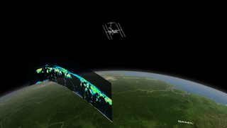
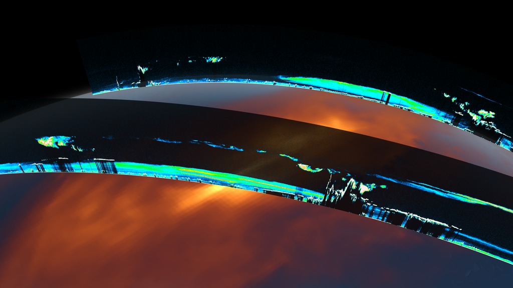
NASA’s Cloud-Aerosol Transport System, or CATS, is a lidar remote-sensing instrument taking measurements of atmospheric aerosols and clouds from the International Space Station (ISS). Launched to the ISS in January 2015, CATS is specifically intended to demonstrate a low-cost, streamlined approach to developing ISS science payloads. The CATS mission extends the data record of space-based aerosol and cloud measurements to ensure the continuity of lidar climate observation.
Data from CATS will help scientists model the structure of dust plumes and other atmospheric features, which can travel far distances and impact air quality. Climate scientists will also use the CATS data, along with data from other Earth-observing instruments, to look at trends and interactions in clouds and aerosols over time.
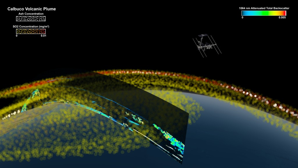
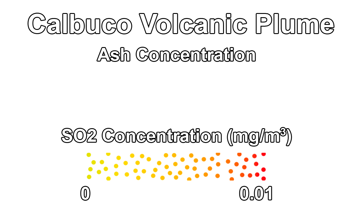
Calbco Eruption
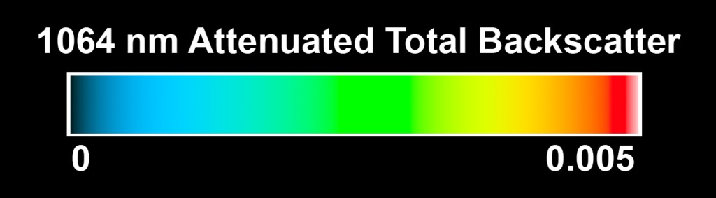
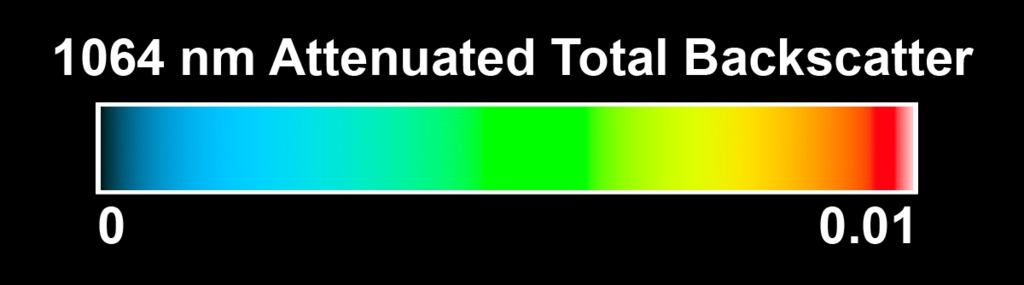
CATS and the ISS provide critical measurements of volcanic plume heights. In late April 2015, the Calbuco Volcano in Chile erupted multiple times; sending plumes of sulfur dioxide and ash into the upper troposphere.
Volcanic plumes pose a substantial risk to aviation safety, leading to prolonged flight cancellations that cause ripple effects in the airline industry’s economy and on personal travel. Rerouting air traffic requires accurate forecasts of volcanic plume transport from models such as the NASA GEOS-5 shown here. Utilizing the near-real-time data downlinking capabilities on ISS the CATS team can produce useful data products within six hours of data collection.
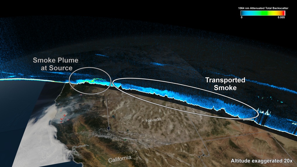
Oregon Wildfires
In addition to the aviation industry, fire management and air quality agencies use data from CATS mounted on the ISS. This visualization shows smoke that reached as high as 5 km. from wildfires in Oregon on August 18 2015. CATS has demonstrated the ability to detect the vertical structure of smoke plumes within an unprecedented 6 hour window of data collection.
Accurate monitoring and forecasting of air quality requires these CATS vertical profiles measurements. Smoke plumes from wildfires are common over North America in summer months, causing deadly respiratory illnesses. Aerosols near the Earth’s surface contribute to an annual death toll of 68,000 Americans and 3.3 million people globally.
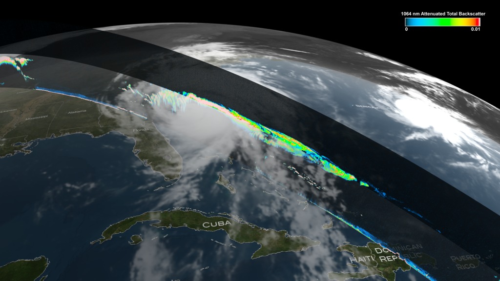
Hurricane Matthew
CATS measurements at different local times over the tropics and mid-latitudes provide comprehensive spatial and temporal coverage of clouds associated with mid-latitude storms and convective systems.
In this example, CATS observed outflow anvil cirrus and convective clouds near the core of Hurricane Matthew, which wreaked havoc on the Southeast U.S. and Caribbean in October this year.
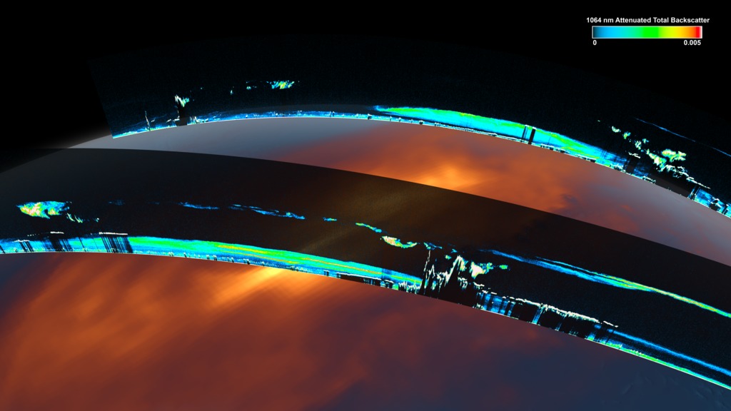
African Dust
The CATS instrument uses different wavelengths which reflect differently when they hit aerosols, so comparing the returns from multiple wavelengths allows the scientists to distinguish dust from ice, smoke or other airborne particles. Over northern Africa, particles – likely dust kicked up by Saharan windstorms – reach heights of 2.5 to 3 miles (4 to 5 kilometers).
Data from CATS will help scientists model the structure of dust plumes and other atmospheric features, which can travel far distances and impact air quality. Climate scientists will also use the CATS data, along with data from other Earth-observing instruments, to look at trends and interactions in clouds and aerosols over time.

CATS studies volcanic plumes, wildfires, and hurricanes
Data from CATS will help scientists model the structure of dust plumes and other atmospheric features, which can travel far distances and impact air quality. Climate scientists will also use the CATS data, along with data from other Earth-observing instruments, to look at trends and interactions in clouds and aerosols over time.
Calbco Eruption
CATS and the ISS provide critical measurements of volcanic plume heights. In late April 2015, the Calbuco Volcano in Chile erupted multiple times; sending plumes of sulfur dioxide and ash into the upper troposphere.
Volcanic plumes pose a substantial risk to aviation safety, leading to prolonged flight cancellations that cause ripple effects in the airline industry’s economy and on personal travel. Rerouting air traffic requires accurate forecasts of volcanic plume transport from models such as the NASA GEOS-5 shown here. Utilizing the near-real-time data downlinking capabilities on ISS the CATS team can produce useful data products within six hours of data collection.
In addition to the aviation industry, fire management and air quality agencies use data from CATS mounted on the ISS. This visualization shows smoke that reached as high as 5 km. from wildfires in Oregon on August 18 2015. CATS has demonstrated the ability to detect the vertical structure of smoke plumes within an unprecedented 6 hour window of data collection.
Accurate monitoring and forecasting of air quality requires these CATS vertical profiles measurements. Smoke plumes from wildfires are common over North America in summer months, causing deadly respiratory illnesses. Aerosols near the Earth’s surface contribute to an annual death toll of 68,000 Americans and 3.3 million people globally.
CATS measurements at different local times over the tropics and mid-latitudes provide comprehensive spatial and temporal coverage of clouds associated with mid-latitude storms and convective systems.
In this example, CATS observed outflow anvil cirrus and convective clouds near the core of Hurricane Matthew, which wreaked havoc on the Southeast U.S. and Caribbean in October this year.
The CATS instrument uses different wavelengths which reflect differently when they hit aerosols, so comparing the returns from multiple wavelengths allows the scientists to distinguish dust from ice, smoke or other airborne particles. Over northern Africa, particles – likely dust kicked up by Saharan windstorms – reach heights of 2.5 to 3 miles (4 to 5 kilometers).
Data from CATS will help scientists model the structure of dust plumes and other atmospheric features, which can travel far distances and impact air quality. Climate scientists will also use the CATS data, along with data from other Earth-observing instruments, to look at trends and interactions in clouds and aerosols over time.
Used Elsewhere In
Visualization Credits
Kel Elkins (USRA): Lead Visualizer
Laurence Schuler (ADNET Systems, Inc.): Technical Support
Ian Jones (ADNET Systems, Inc.): Technical Support
John E. Yorks (SSAI): Lead Scientist
Michael Starobin (HTSI): Lead Producer
Laurence Schuler (ADNET Systems, Inc.): Technical Support
Ian Jones (ADNET Systems, Inc.): Technical Support
John E. Yorks (SSAI): Lead Scientist
Michael Starobin (HTSI): Lead Producer
Please give credit for this item to:
NASA's Scientific Visualization Studio
NASA's Scientific Visualization Studio
Short URL to share this page:
https://svs.gsfc.nasa.gov/4542
Mission:
Cloud-Aerosol Transport System (CATS)
Data Used:
Note: While we identify the data sets used in these visualizations, we do not store any further details nor the data sets themselves on our site.
Keywords:
SVS >> Earth
SVS >> Hyperwall
SVS >> CATS
SVS >> ISS
NASA Science >> Earth
SVS >> Presentation
https://svs.gsfc.nasa.gov/4542
Mission:
Cloud-Aerosol Transport System (CATS)
Data Used:
ISS/Cloud-Aerosol Transport System/Lidar also referred to as: CATS
Observed Data - 04/27/2015, 8/18/2015, 10/07/2016
NASA's Cloud-Aerosol Transport System, or CATS, is a lidar remote-sensing instrument taking measurements of atmospheric aerosols and clouds from the International Space Station (ISS). Launched to the ISS in January 2015, CATS is specifically intended to demonstrate a low-cost, streamlined approach to developing ISS science payloads. The CATS mission extends
Keywords:
SVS >> Earth
SVS >> Hyperwall
SVS >> CATS
SVS >> ISS
NASA Science >> Earth
SVS >> Presentation


