Earth
ID: 4477
GRACE (Gravity Recovery and Climate Experiment) maps variations in Earth's gravity field. GRACE consists of two identical spacecraft that fly about 220 kilometers (137 miles) apart in a polar orbit 500 kilometers (310 miles) above Earth. GRACE maps Earth's gravity field by making accurate measurements of the distance between the two satellites, using GPS and a microwave ranging system. It is providing scientists from all over the world with an efficient and cost-effective way to map Earth's gravity field with unprecedented accuracy. The results from this mission are yielding crucial information about the distribution and flow of mass within Earth and its surroundings.
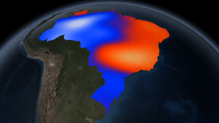
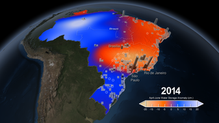
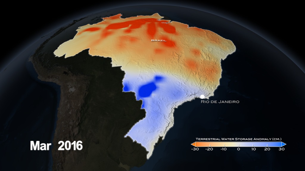
The gravity variations studied by GRACE can be used to determine ground water storage on land masses. By comparing current data to an average over time, scientists can generate an anomaly map to see where ground water storage has been depleted or increased.
GRACE is a joint partnership between the National Aeronautics and Space Administration (NASA) in the United States and Deutsche Forschungsanstalt für Luft und Raumfahrt (DLR) in Germany. Project management and systems engineering activities are carried out by the Jet Propulsion Laboratory.

GRACE over Brazil (March 2015 - March 2016)
The gravity variations studied by GRACE can be used to determine ground water storage on land masses. By comparing current data to an average over time, scientists can generate an anomaly map to see where ground water storage has been depleted or increased.
GRACE is a joint partnership between the National Aeronautics and Space Administration (NASA) in the United States and Deutsche Forschungsanstalt für Luft und Raumfahrt (DLR) in Germany. Project management and systems engineering activities are carried out by the Jet Propulsion Laboratory.
Older Versions
Related
Visualization Credits
Alex Kekesi (Global Science and Technology, Inc.): Lead Visualizer
Doug C. Morton (NASA/GSFC): Lead Scientist
Yang Chen (University of California, Irvine): Scientist
Michelle Handleman (USRA): Lead Producer
Claire Saravia (NASA/GSFC): Lead Producer
Matthew R. Radcliff (USRA): Producer
Doug C. Morton (NASA/GSFC): Lead Scientist
Yang Chen (University of California, Irvine): Scientist
Michelle Handleman (USRA): Lead Producer
Claire Saravia (NASA/GSFC): Lead Producer
Matthew R. Radcliff (USRA): Producer
Please give credit for this item to:
NASA's Scientific Visualization Studio
NASA's Scientific Visualization Studio
Short URL to share this page:
https://svs.gsfc.nasa.gov/4477
Mission:
Gravity Recovery and Climate Experiment (GRACE)
Data Used:
Note: While we identify the data sets used in these visualizations, we do not store any further details nor the data sets themselves on our site.
Keywords:
DLESE >> Atmospheric science
SVS >> HDTV
DLESE >> Natural hazards
GCMD >> Earth Science >> Climate Indicators >> Drought Indices
GCMD >> Earth Science >> Atmosphere >> Atmospheric Phenomena >> Drought
GCMD >> Earth Science >> Hydrosphere >> Surface Water >> Watershed Characteristics
SVS >> Hyperwall
NASA Science >> Earth
GCMD >> Earth Science >> Climate Indicators >> Land Surface/agriculture Indicators >> Drought Indices
GCMD >> Earth Science >> Human Dimensions >> Natural Hazards >> Droughts
GCMD keywords can be found on the Internet with the following citation: Olsen, L.M., G. Major, K. Shein, J. Scialdone, S. Ritz, T. Stevens, M. Morahan, A. Aleman, R. Vogel, S. Leicester, H. Weir, M. Meaux, S. Grebas, C.Solomon, M. Holland, T. Northcutt, R. A. Restrepo, R. Bilodeau, 2013. NASA/Global Change Master Directory (GCMD) Earth Science Keywords. Version 8.0.0.0.0
https://svs.gsfc.nasa.gov/4477
Mission:
Gravity Recovery and Climate Experiment (GRACE)
Data Used:
Gravity Recovery and Climate Experiment (GRACE)/Terrestrial Water Storage Anomaly also referred to as: TWS Anomaly
Analysis - 3/2015 - 3/2016Keywords:
DLESE >> Atmospheric science
SVS >> HDTV
DLESE >> Natural hazards
GCMD >> Earth Science >> Climate Indicators >> Drought Indices
GCMD >> Earth Science >> Atmosphere >> Atmospheric Phenomena >> Drought
GCMD >> Earth Science >> Hydrosphere >> Surface Water >> Watershed Characteristics
SVS >> Hyperwall
NASA Science >> Earth
GCMD >> Earth Science >> Climate Indicators >> Land Surface/agriculture Indicators >> Drought Indices
GCMD >> Earth Science >> Human Dimensions >> Natural Hazards >> Droughts
GCMD keywords can be found on the Internet with the following citation: Olsen, L.M., G. Major, K. Shein, J. Scialdone, S. Ritz, T. Stevens, M. Morahan, A. Aleman, R. Vogel, S. Leicester, H. Weir, M. Meaux, S. Grebas, C.Solomon, M. Holland, T. Northcutt, R. A. Restrepo, R. Bilodeau, 2013. NASA/Global Change Master Directory (GCMD) Earth Science Keywords. Version 8.0.0.0.0


