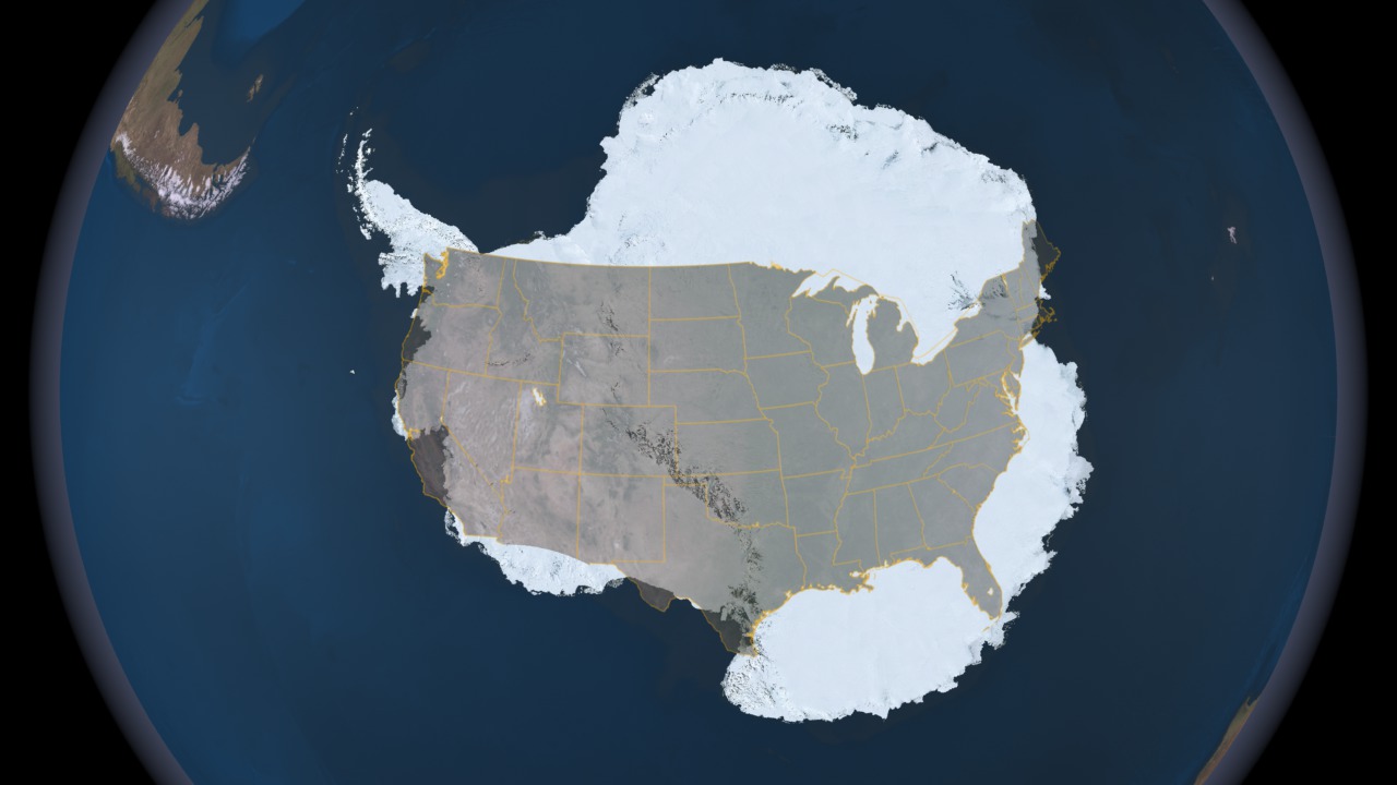
Compare the Size of Antarctica to the Continental United States
The total surface area is about 14.2 million sq km (about 5.5 million sq mls) in summer, much larger then the continental United States, approximately twice the size of Australia, and fifty times the size of the UK. In this still image, Antarctica is shown using the Landsat Image Mosaic of Antarctica (LIMA) data with the continental United States overlaid on top for size comparison. The Landsat Image Mosaic of Antarctica (LIMA) is a data product funded by the National Science Foundation (NSF) and jointly produced by the U.S. Geological Survey (USGS), the British Antarctic Survey (BAS), and the National Aeronautics and Space Administration (NASA). The LIMA data shown here uses the pan-chromatic band and has a resolution of 15 meters per pixel. The 13 swaths used to generate this sample mosaic where acquired between December 25, 1999 and December 31, 2001. The elevation data shown has no vertical exaggeration (1x) and is courtesy of the Radarsat Antarctic Mapping Project (RAMP) Digital Elevation Model (DEM).
Visualization Credits
NASA/Goddard Space Flight Center Scientific Visualization Studio
LIMA Data provided by: Patricia Vornberger (SAIC)
LIMA data produced by U.S. Geological Survey (USGS), the British Antarctic Survey (BAS) and NASA
https://svs.gsfc.nasa.gov/3540
Mission:
Landsat
Data Used:
Landsat-7/ETM+/Band Combination 3, 2, 1
Landsat-7/ETM+/Landsat Image Mosaic of Antarctica also referred to as: LIMA
Mosaic - NASA/GSFC, British Antarctic Survey, USGS EROS Data Center - 12/25/1999 - 12/31/2001This item is part of this series:
Landsat Image Mosaic of Antarctica
Keywords:
SVS >> HDTV
GCMD >> Earth Science >> Cryosphere >> Glaciers/Ice Sheets
GCMD >> Earth Science >> Cryosphere >> Glaciers/Ice Sheets >> Glacier Elevation/Ice Sheet Elevation
GCMD >> Earth Science >> Cryosphere >> Glaciers/Ice Sheets >> Glacier Topography/Ice Sheet Topography
GCMD >> Location >> Antarctica
SVS >> Hyperwall
NASA Science >> Earth
GCMD keywords can be found on the Internet with the following citation: Olsen, L.M., G. Major, K. Shein, J. Scialdone, S. Ritz, T. Stevens, M. Morahan, A. Aleman, R. Vogel, S. Leicester, H. Weir, M. Meaux, S. Grebas, C.Solomon, M. Holland, T. Northcutt, R. A. Restrepo, R. Bilodeau, 2013. NASA/Global Change Master Directory (GCMD) Earth Science Keywords. Version 8.0.0.0.0


