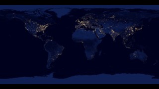
Earth
ID: 31099
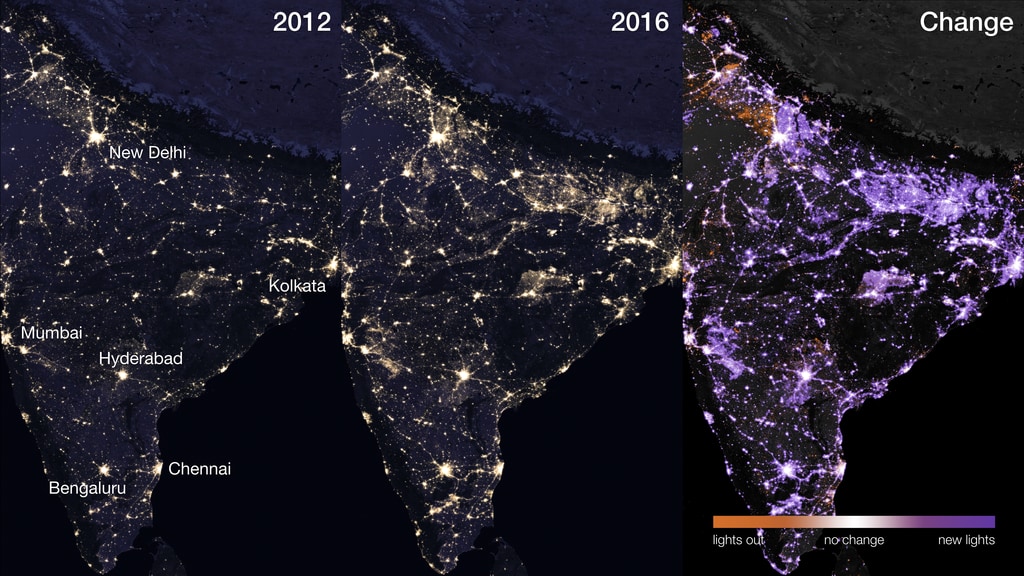
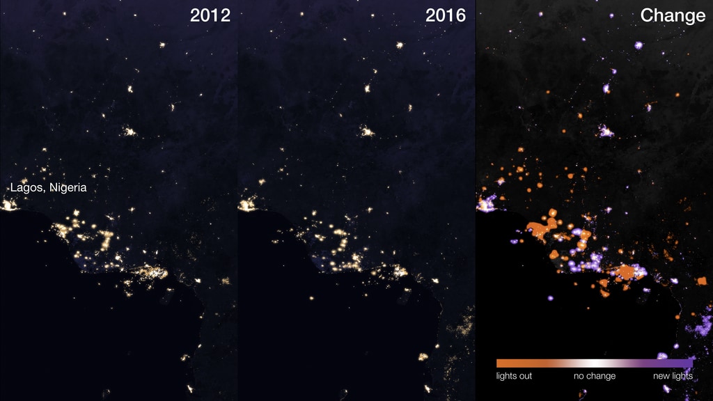
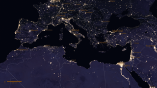
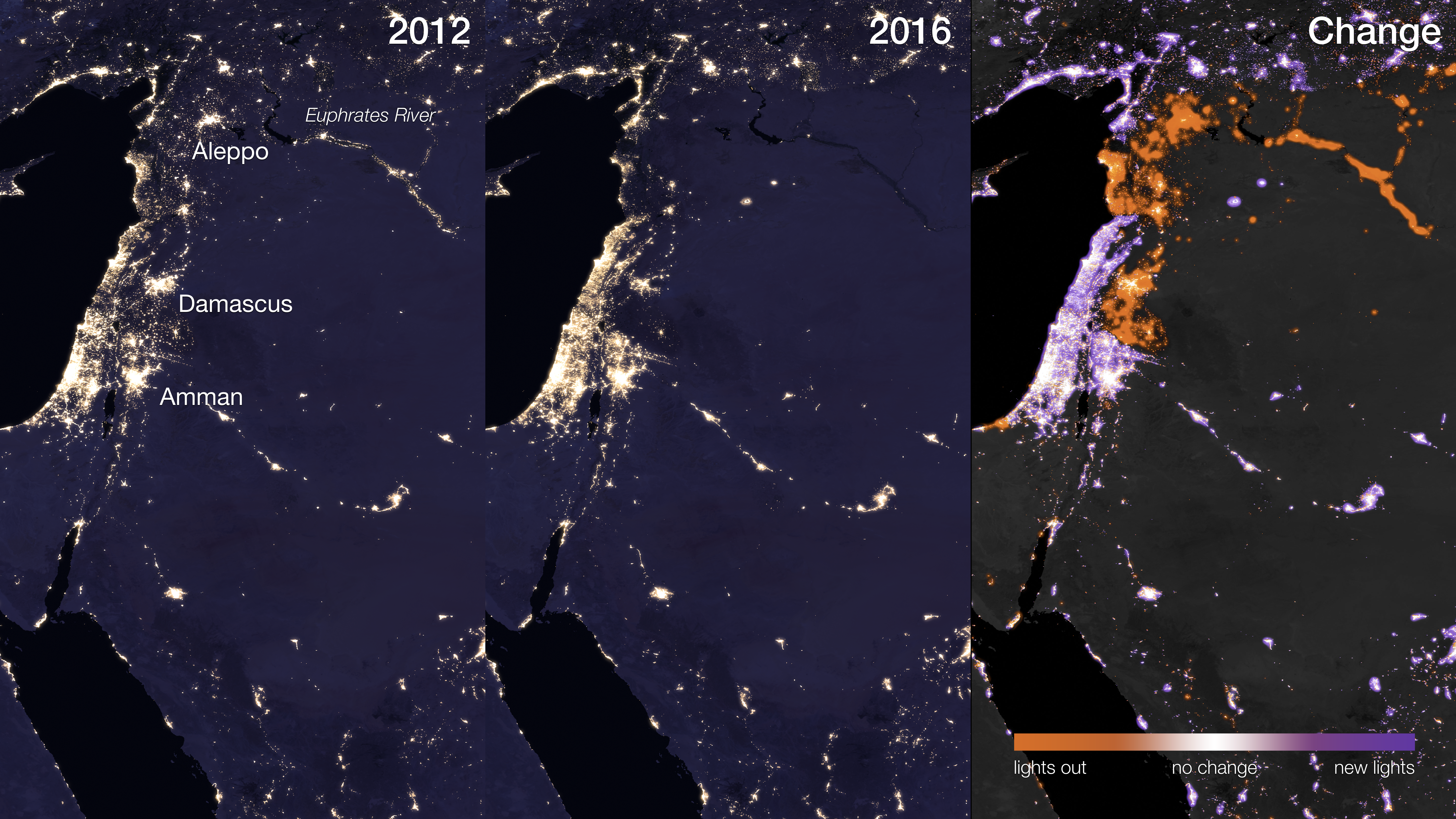
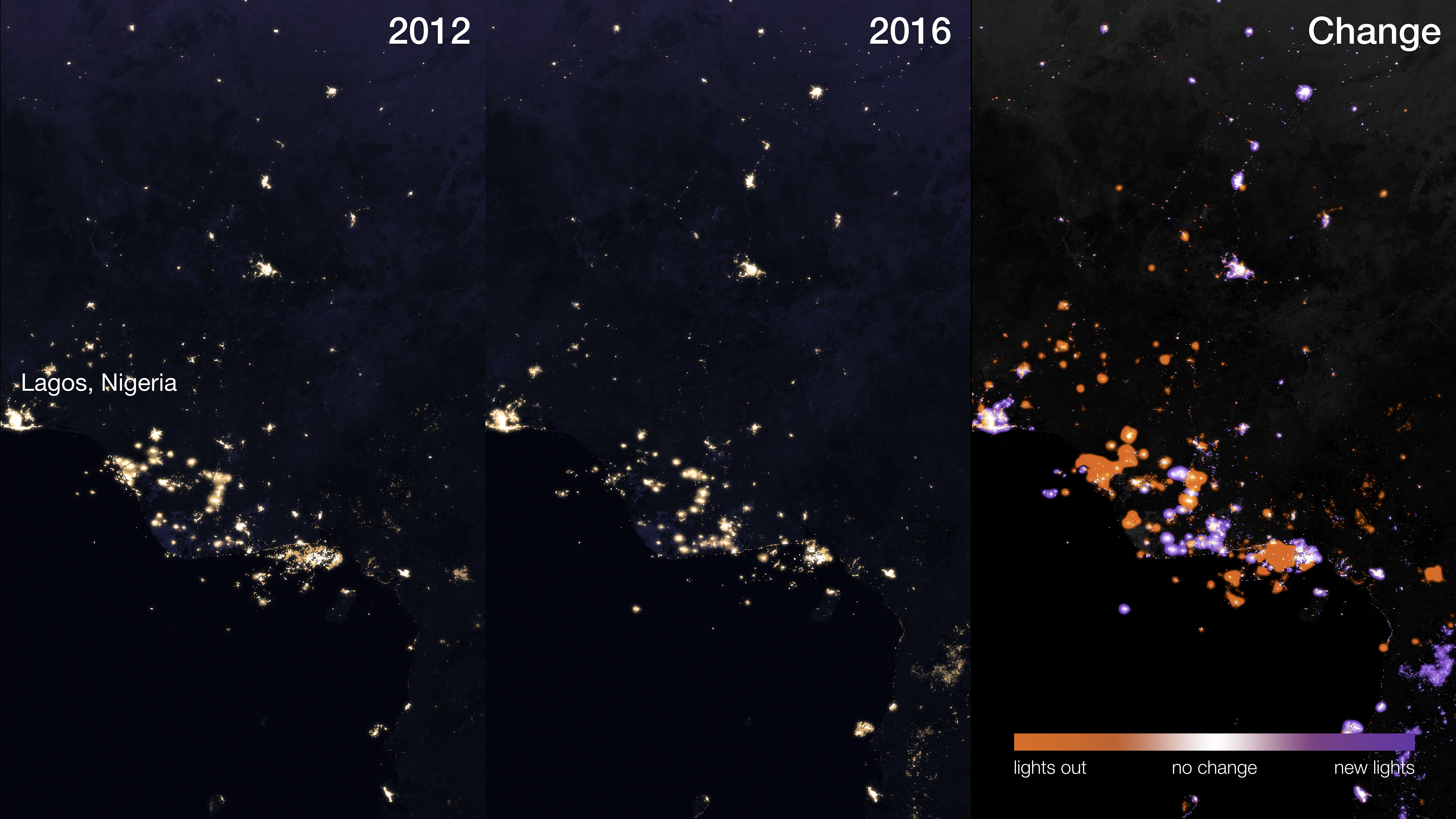
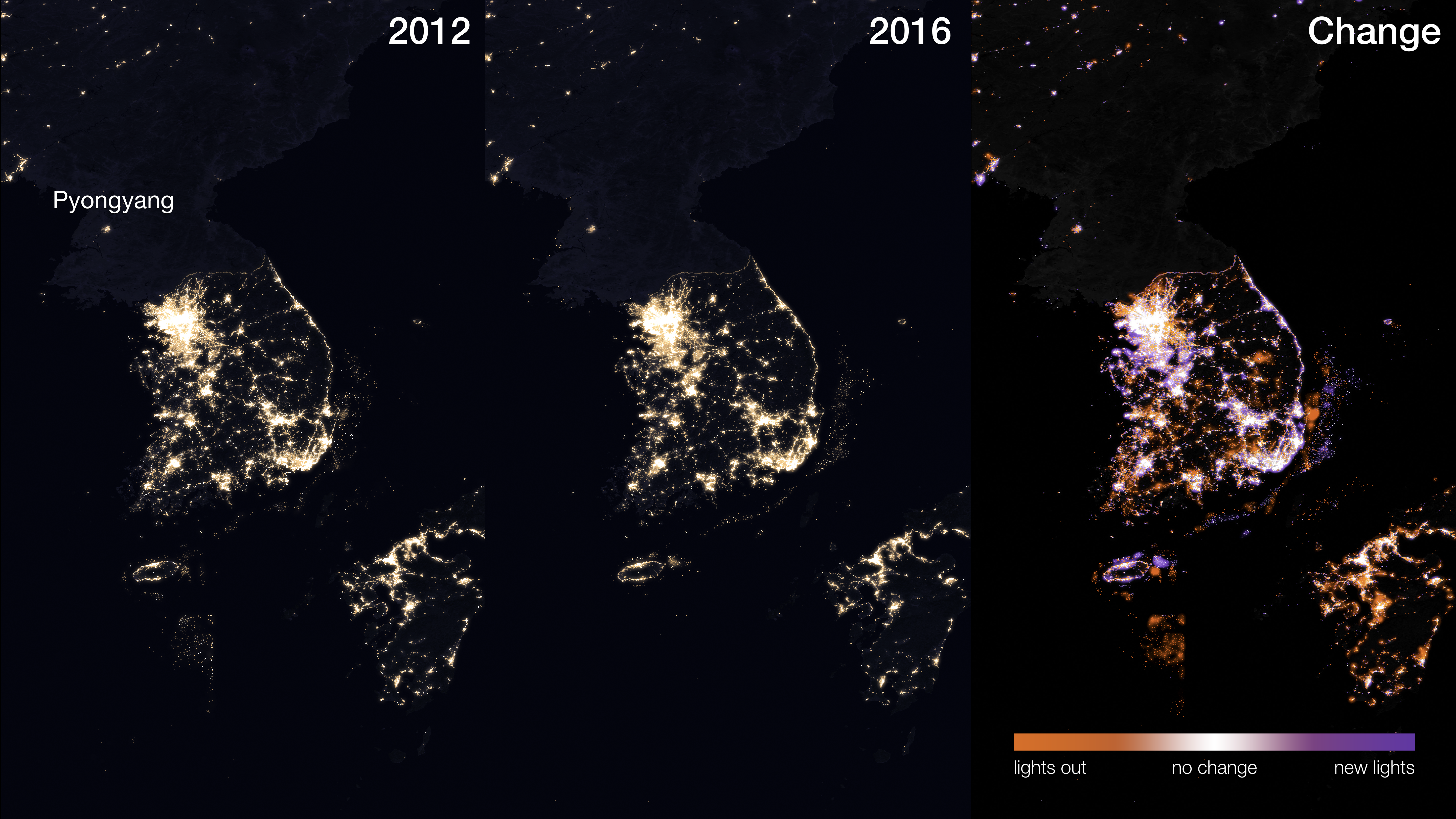
These images show the change in lighting intensity from 2012 to 2016 in several regions of interest. The maps were created using two separate night lights datasets (from 2012 and 2016) derived using data from the Visible Infrared Imaging Radiometer Suite (VIIRS) on the National Oceanic and Atmospheric Administration (NOAA)-NASA Suomi National Polar-orbiting Partnership (NPP) satellite. Each pixel represents 500 meters (1640 feet), or approximately six city blocks. Dark purple represents areas with new light since 2012, while dark orange represents areas where light existed in 2012 but no longer exists in 2016. Areas where lighting intensity stayed the same between 2012 and 2016 appear white. Varying shades of purple and orange indicate areas that have become brighter or dimmer since 2012, respectively.
Scientists use the Suomi NPP night lights dataset in many ways. Some applications include: forecasting a city’s energy use and carbon emissions, eradicating energy poverty and fostering sustainable energy development, providing immediate information when disasters strike, and monitoring the effects of conflict and population displacement.
In recent years, India has undergone rapid electrification (purple). In Syria, six years of war have had a devastating effect on millions of its people. One of the most catastrophic impacts has been on the country’s electricity network. Lights have gone out (orange) during the course of the conflict, leaving people to survive with little to no power. In Nigeria, light from gas flaring activity decreased from 2012 to 2016 (orange), largely due to international agreements acted on by the country. On the Korean peninsula, the border between North and South Korea is apparent. While South Korea is gleaming with city lights, North Korea has hardly any lights at all beyond a faint glimmer around Pyongyang. The light from fishing boats is also visible.


A Changing Earth at Night (Regions)
Scientists use the Suomi NPP night lights dataset in many ways. Some applications include: forecasting a city’s energy use and carbon emissions, eradicating energy poverty and fostering sustainable energy development, providing immediate information when disasters strike, and monitoring the effects of conflict and population displacement.
In recent years, India has undergone rapid electrification (purple). In Syria, six years of war have had a devastating effect on millions of its people. One of the most catastrophic impacts has been on the country’s electricity network. Lights have gone out (orange) during the course of the conflict, leaving people to survive with little to no power. In Nigeria, light from gas flaring activity decreased from 2012 to 2016 (orange), largely due to international agreements acted on by the country. On the Korean peninsula, the border between North and South Korea is apparent. While South Korea is gleaming with city lights, North Korea has hardly any lights at all beyond a faint glimmer around Pyongyang. The light from fishing boats is also visible.
Related
Credits
Miguel Román (NASA/GSFC): Scientist
Please give credit for this item to:
NASA's Goddard Space Flight Center
NASA's Goddard Space Flight Center
Short URL to share this page:
https://svs.gsfc.nasa.gov/31099
Mission:
Suomi NPP
Data Used:
Note: While we identify the data sets used in these visualizations, we do not store any further details nor the data sets themselves on our site.
Keywords:
SVS >> Korea
SVS >> Night
SVS >> Night lights
GCMD >> Earth Science >> Human Dimensions >> Population >> Population Distribution
GCMD >> Location >> India
GCMD >> Location >> Nigeria
GCMD >> Location >> North Korea
GCMD >> Location >> South Korea
GCMD >> Location >> Syria
SVS >> Hyperwall
NASA Science >> Earth
GCMD >> Earth Science >> Human Dimensions >> Population >> Population Estimates
GCMD keywords can be found on the Internet with the following citation: Olsen, L.M., G. Major, K. Shein, J. Scialdone, S. Ritz, T. Stevens, M. Morahan, A. Aleman, R. Vogel, S. Leicester, H. Weir, M. Meaux, S. Grebas, C.Solomon, M. Holland, T. Northcutt, R. A. Restrepo, R. Bilodeau, 2013. NASA/Global Change Master Directory (GCMD) Earth Science Keywords. Version 8.0.0.0.0
https://svs.gsfc.nasa.gov/31099
Mission:
Suomi NPP
Data Used:
Suomi NPP/VIIRS also referred to as: VIIRS
Keywords:
SVS >> Korea
SVS >> Night
SVS >> Night lights
GCMD >> Earth Science >> Human Dimensions >> Population >> Population Distribution
GCMD >> Location >> India
GCMD >> Location >> Nigeria
GCMD >> Location >> North Korea
GCMD >> Location >> South Korea
GCMD >> Location >> Syria
SVS >> Hyperwall
NASA Science >> Earth
GCMD >> Earth Science >> Human Dimensions >> Population >> Population Estimates
GCMD keywords can be found on the Internet with the following citation: Olsen, L.M., G. Major, K. Shein, J. Scialdone, S. Ritz, T. Stevens, M. Morahan, A. Aleman, R. Vogel, S. Leicester, H. Weir, M. Meaux, S. Grebas, C.Solomon, M. Holland, T. Northcutt, R. A. Restrepo, R. Bilodeau, 2013. NASA/Global Change Master Directory (GCMD) Earth Science Keywords. Version 8.0.0.0.0


