Earth
ID: 30053
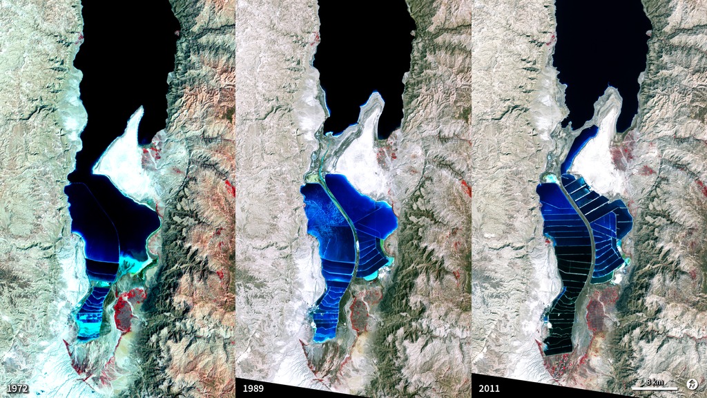
The Dead Sea is so named because its high salinity discourages the growth of fish, plants, and other wildlife. It is the lowest surface feature on Earth, sitting roughly 1,300 feet below sea level. On a hot, dry summer day, the water level can drop as much as one inch because of evaporation. These three false-color images were captured in 1972, 1989, and 2011 by Landsat satellites. Deep waters are blue or dark blue, while brighter blues indicate shallow waters or salt ponds. Green indicates sparsely vegetated lands. Denser vegetation appears bright red. The ancient Egyptians used salts from the Dead Sea for mummification, fertilizers, and potash (a potassium-based salt). In the modern age, sodium chloride and potassium salts culled from the sea are used for water conditioning, road de-icing, and the manufacturing of polyvinyl chloride (PVC) plastics. The expansions of massive salt evaporation projects are clearly visible over the span of 39 years.
Dead Sea Salt Farming
For More Information
Credits
Robert Simmon (Sigma Space Corporation): Lead Animator
Mark Malanoski (GST): Project Support
Aries Keck (ADNET Systems, Inc.): Writer
Mike Carlowicz (Sigma Space Corporation): Writer
Mark Malanoski (GST): Project Support
Aries Keck (ADNET Systems, Inc.): Writer
Mike Carlowicz (Sigma Space Corporation): Writer
Please give credit for this item to:
NASA's Goddard Space Flight Center
NASA's Goddard Space Flight Center
Short URL to share this page:
https://svs.gsfc.nasa.gov/30053
Mission:
Landsat
Data Used: Note: While we identify the data sets used in these visualizations, we do not store any further details nor the data sets themselves on our site.
Keywords:
DLESE >> Geology
DLESE >> Human geography
SVS >> Landsat
DLESE >> Physical geography
GCMD >> Earth Science >> Land Surface >> Landscape
GCMD >> Earth Science >> Land Surface >> Erosion/Sedimentation >> Landslides
SVS >> Hyperwall
NASA Science >> Earth
SVS >> Presentation
GCMD keywords can be found on the Internet with the following citation: Olsen, L.M., G. Major, K. Shein, J. Scialdone, S. Ritz, T. Stevens, M. Morahan, A. Aleman, R. Vogel, S. Leicester, H. Weir, M. Meaux, S. Grebas, C.Solomon, M. Holland, T. Northcutt, R. A. Restrepo, R. Bilodeau, 2013. NASA/Global Change Master Directory (GCMD) Earth Science Keywords. Version 8.0.0.0.0


