Earth
ID: 13114
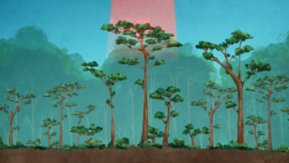
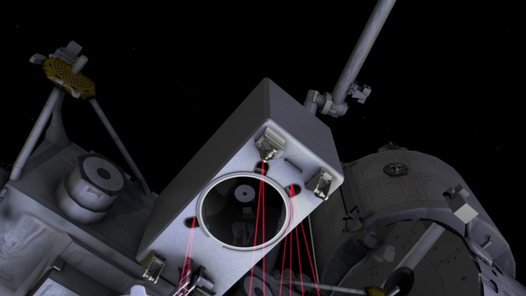
The Global Ecosystem Dynamics Investigation, or GEDI, uses advanced laser technology to reveal the makeup of remote forest ecosystems around the globe. Its measurements of the height of leaves, branches, trees, and shrubs below its path will help scientists map the structure of forests and better understand how ecosystems are storing or releasing carbon.
GEDI's lidar instrument sends laser pulses down to Earth, where they penetrate the globe’s temperate and tropical forests. The laser beams ricochet off the first thing they hit, which can be a leaf atop a dense canopy, a protruding branch, or the ground from which the forest emerges. The energy returned to the GEDI telescope on the International Space Station will provide and intricate three-dimensional map of forest canopies.
"We can send out a little pulse of light and it travels down, reflects off the surface, and comes back," Bryan Blair, GEDI instrument scientist and deputy principal investigator, said. "We can see and measure how tall the tree is and we can actually see how dense it is as we go down."
GEDI Overview
GEDI's lidar instrument sends laser pulses down to Earth, where they penetrate the globe’s temperate and tropical forests. The laser beams ricochet off the first thing they hit, which can be a leaf atop a dense canopy, a protruding branch, or the ground from which the forest emerges. The energy returned to the GEDI telescope on the International Space Station will provide and intricate three-dimensional map of forest canopies.
"We can send out a little pulse of light and it travels down, reflects off the surface, and comes back," Bryan Blair, GEDI instrument scientist and deputy principal investigator, said. "We can see and measure how tall the tree is and we can actually see how dense it is as we go down."
Source Material
Related
Credits
Matthew R. Radcliff (USRA): Lead Producer
Aaron E. Lepsch (ADNET Systems, Inc.): Technical Support
Rob Andreoli (Advocates in Manpower Management, Inc.): Videographer
John Caldwell (Advocates in Manpower Management, Inc.): Videographer
Ralph Dubayah (University of Maryland): Scientist
Bryan Blair (NASA/GSFC): Scientist
Ralph Dubayah (University of Maryland): Interviewee
Bryan Blair (NASA/GSFC): Interviewee
Lisa Poje (Freelance): Animator
Walt Feimer (KBR Wyle Services, LLC): Animator
Please give credit for this item to:
NASA's Goddard Space Flight Center
NASA's Goddard Space Flight Center
Short URL to share this page:
https://svs.gsfc.nasa.gov/13114
This item is part of these series:
Narrated Movies
International Space Station
Keywords:
SVS >> Biomass
SVS >> Canopy
SVS >> Carbon Absorption
SVS >> Carbon Cycle
SVS >> HDTV
SVS >> Biosphere >> Forestry
NASA Science >> Earth
https://svs.gsfc.nasa.gov/13114
This item is part of these series:
Narrated Movies
International Space Station
Keywords:
SVS >> Biomass
SVS >> Canopy
SVS >> Carbon Absorption
SVS >> Carbon Cycle
SVS >> HDTV
SVS >> Biosphere >> Forestry
NASA Science >> Earth


