Earth
ID: 12702
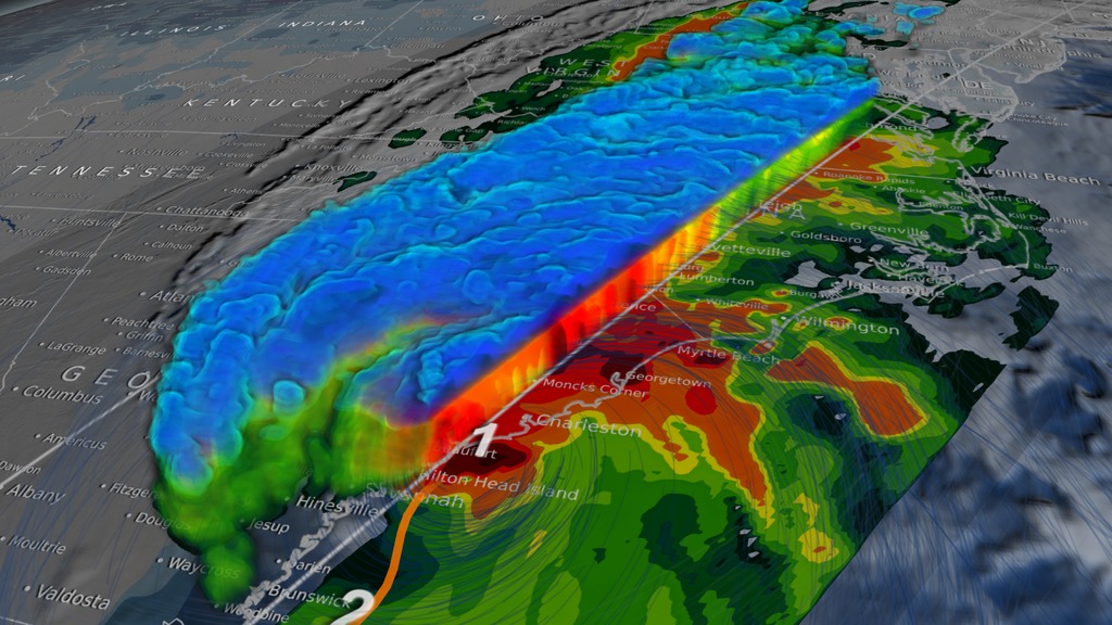
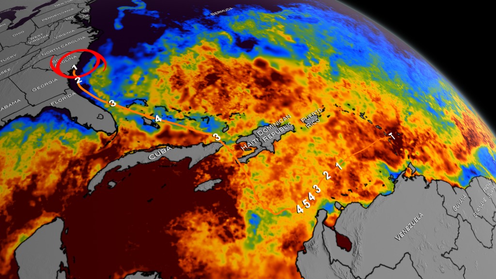
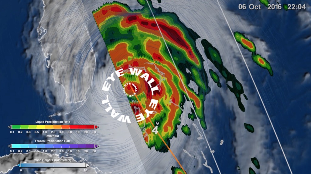
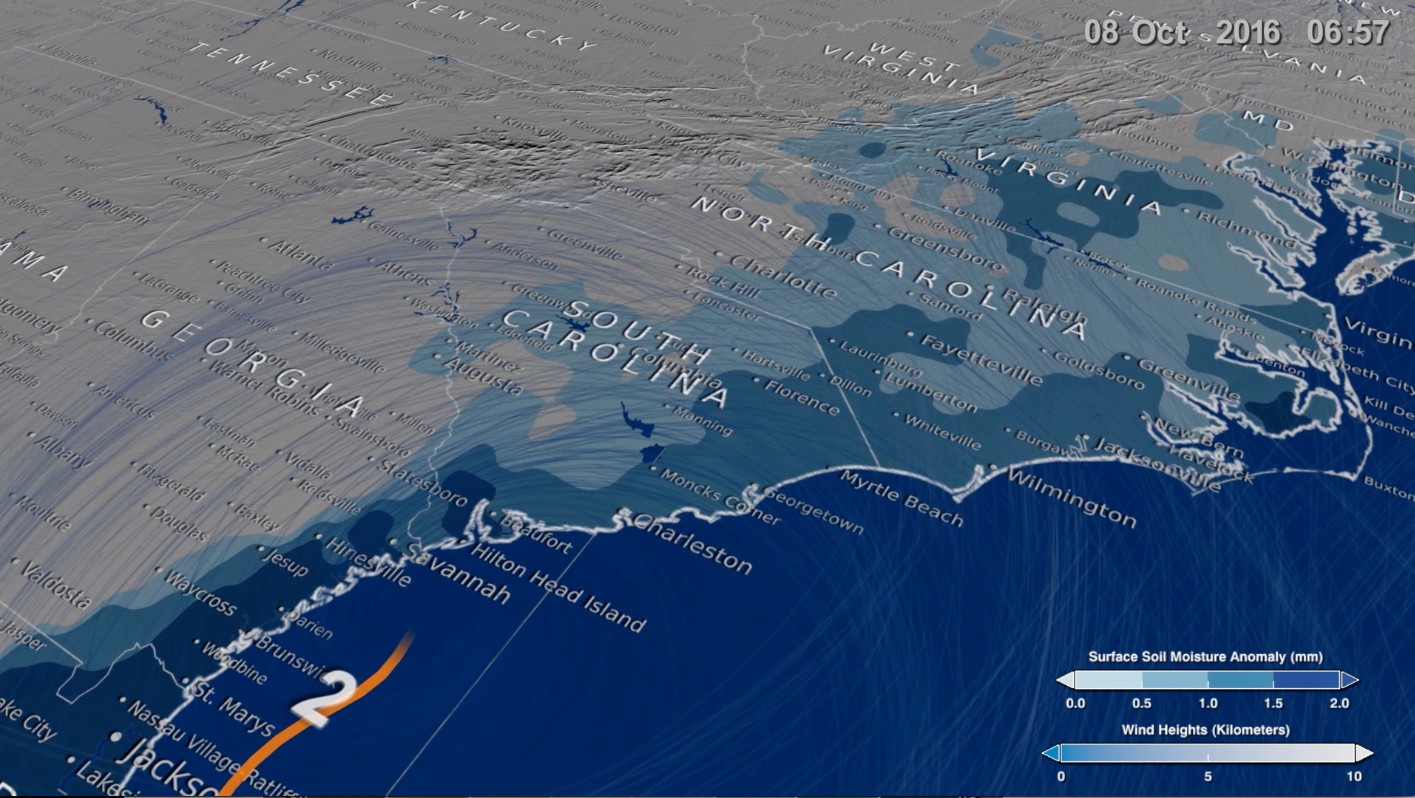
Hurricane Matthew was the most devastating hurricane of the 2016 season and the first Category 5 hurricane in the Atlantic since 2007. The storm swept through the Caribbean and up the southeastern coast of the United States, making landfall in South Carolina on Oct. 8 as a Category 1 storm. The combination of strong storm surge and a foot of rainfall led to widespread and devastating flooding in North and South Carolina. Since the storm, scientists have revisted the data to better understand how hurricanes like Matthew react to different conditions in the ocean and atmosphere. They combined rainfall and rainfall accumulation data from the joint NASA-Japan Global Precipitation Measurement mission satellite with high-resolution sea surface temperature data from NASA's Jet Propulsion Laboratory, soil moisture data from NASA's Soil Moisture Active Passive mission, and wind speeds and a sea surface pressures simulated by computer models. Watch the videos to learn how combining multiple data set lead scientists to a more meaningful picture of Hurricane Matthew.

Slicing Through Hurricane Matthew
For More Information
Story Credits
Lead Visualizer/Animator:
Alex Kekesi (Global Science and Technology, Inc.)
Visualizers/Animators:
Greg Shirah (NASA/GSFC)
Horace Mitchell (NASA/GSFC)
Trent L. Schindler (USRA)
Ernie Wright (USRA)
Lead Producer:
Ryan Fitzgibbons (USRA)
Scientists:
Gail Skofronick Jackson (NASA/GSFC)
Dalia B Kirschbaum (NASA/GSFC)
Lead Scientist:
George Huffman (NASA/GSFC)
Lead Writer:
Ryan Fitzgibbons (USRA)
Please give credit for this item to:
NASA's Scientific Visualization Studio
NASA's Scientific Visualization Studio
Short URL to share this page:
https://svs.gsfc.nasa.gov/12702
Mission:
Global Precipitation Measurement (GPM)
Data Used:
Note: While we identify the data sets used in these visualizations, we do not store any further details nor the data sets themselves on our site.
Keywords:
SVS >> HDTV
SVS >> App
NASA Science >> Earth
SVS >> Hurricane Matthew
https://svs.gsfc.nasa.gov/12702
Mission:
Global Precipitation Measurement (GPM)
Data Used:
GEOS-5 Atmospheric Model on the Cubed-Sphere also referred to as: GEOS-5 Cubed-Sphere
Model - NASA GMAO
The model is the GEOS-5 atmospheric model on the cubed-sphere, run at 14-km global resolution for 30-days. GEOS-5 is described here http://gmao.gsfc.nasa.gov/systems/geos5/ and the cubed-sphere work is described here http://sivo.gsfc.nasa.gov/cubedsphere_overview.html.
GPM/GMI/Surface Precipitation also referred to as: Rain Rates
Credit:
Data provided by the joint NASA/JAXA GPM mission.
Data provided by the joint NASA/JAXA GPM mission.
GPM/DPR/Ku also referred to as: Volumetric Precipitation data
Observed Data - JAXA
Credit:
Data provided by the joint NASA/JAXA GPM mission.
Data provided by the joint NASA/JAXA GPM mission.
Multi-scale Ultra-high Resolution (MUR) Sea Surface Temperature (SST) Analysis also referred to as: MUR SST
Analysis - JPL PO DAACalso referred to as: IMERG
Data Compilation - NASA/GSFCSurface Soil Moisture corrected with SMOS imagery and assimilated by the Ensemble Kalman Filter also referred to as: NASA-USDA-FAS Soil Moisture
Data Compilation - NASA and USDA
The surface soil moisture product is corrected by integrating satellite-derived Soil Moisture Ocean Salinity (SMOS) mission surface soil moisture retrievals into the modified Palmer two-layer soil moisture model. The SMOS imagery helps to correct the modified Pal
MERRA-2/Winds
ModelKeywords:
SVS >> HDTV
SVS >> App
NASA Science >> Earth
SVS >> Hurricane Matthew


