What Spacecraft Saw During the 2017 Solar Eclipse
NASA and its partner’s satellites had a unique vantage point to watch the eclipse. Several Sun-watching satellites were in a position to see the Moon cross in front of the Sun, while many Earth-observing satellites – and NASA’s Lunar Reconnaissance Orbiter, which typically images the Moon’s landscape – captured images of the Moon’s shadow on Earth’s surface.
See more and download content at https://go.nasa.gov/2x7b8kf
Imagery provided by:
SDO
NASA/SDO
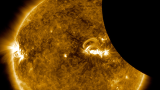
ISS
NASA/ISS
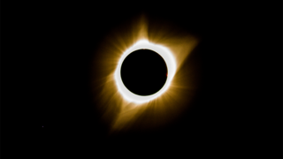
SOHO
inside image credit: Solar Dynamics Observatory, LMSAL and NASA’s GSFC;
Middle image: Jay Pasachoff, Ron Dantowitz, Christian Lockwood, and the Williams College Eclipse Expedition/NSF/National Geographic
Outside image credit: LASCO from NRL on SOHO from ESA/NASA
Hinode
Image credit: JAXA/NASA
GOES
Image credit: NOAA/NASA’s GOES-16
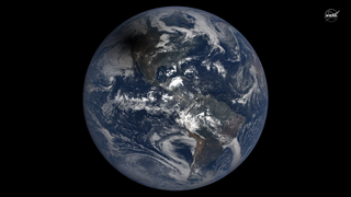
NOAA’s DSCOVR
Image credit: NASA EPIC Team
Terra
Image credit: NASA Earth Observatory images by Joshua Stevens and Jesse Allen, using MODIS data from the Land Atmosphere Near real-time Capability for EOS (LANCE) and EOSDIS/Rapid Response
Suomi NPP
Image credit: NASA Earth Observatory image by Joshua Stevens and Jesse Allen, using VIIRS data from the University of Wisconsin’s Space Science and Engineering Center Direct Broadcast system.
IRIS
Image credit: LMSAL/NASA, Bart De Pontieu
LRO
Image credit: NASA/GSFC/Arizona State University
Source Material
Related
Credits
Scott Wiessinger (USRA): Producer
Kathryn Mersmann (USRA): Producer
Kathalina Tran (KBRwyle): Producer
Sarah Frazier (ADNET Systems, Inc.): Writer
Genna Duberstein (USRA): Editor
NASA's Goddard Space Flight Center
https://svs.gsfc.nasa.gov/12698
This item is part of this series:
Narrated Movies
Keywords:
SVS >> HDTV
SVS >> Moon
SVS >> SOHO
SVS >> Solar Eclipse
SVS >> Transit
SVS >> Space Weather
SVS >> SDO
SVS >> Solar Dynamics Observatory
SVS >> LRO
SVS >> GOES
SVS >> Eclipse
SVS >> LROC
SVS >> Heliophysics
SVS >> Terra
SVS >> Hinode
SVS >> NPP
SVS >> Corona
SVS >> ISS
SVS >> VIIRS
SVS >> MODIS
NASA Science >> Sun
SVS >> IRIS Mission
SVS >> DSCOVR
SVS >> EPIC


