Earth
ID: 10416
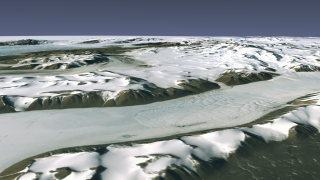
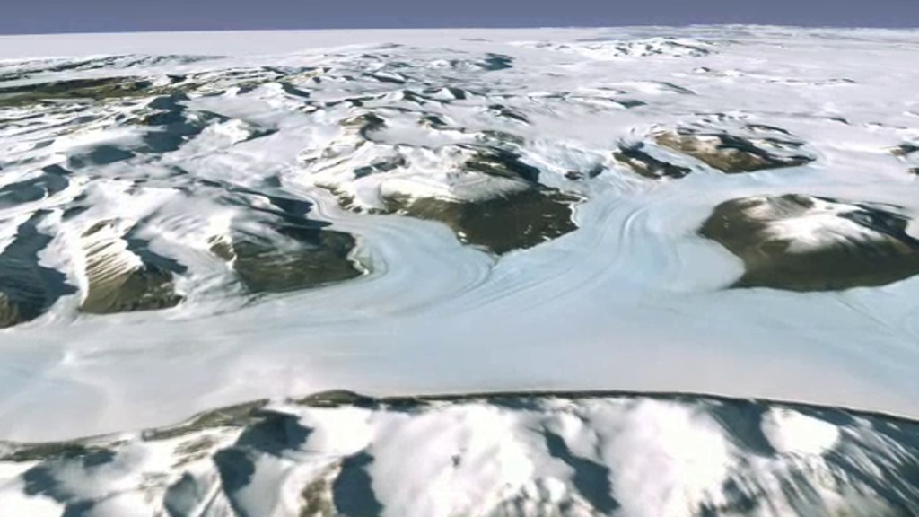
In 2007, more than 1,100 Landsat 7 images were used to create the first ever, high-resolution, true color map of Antarctica. The Landsat Image Mosaic of Antarctica (LIMA) is a virtually cloud-free, 3-D view of Antarctica's frozen landscape produced by NASA, working with the National Science Foundation, the U.S. Geological Survey and the British Antarctic Survey.
Visualizers stitched together Landsat 7 satellite imagery acquired in 1999 and 2001 with a digital elevation model and field data measurements.
Guided Tour of LIMA Flyover
Visualizers stitched together Landsat 7 satellite imagery acquired in 1999 and 2001 with a digital elevation model and field data measurements.
Used Elsewhere In
Related
For More Information
Credits
Lori Perkins (NASA/GSFC): Lead Animator
Michelle Williams (UMBC): Video Editor
Michael Randazzo (Advocates in Manpower Management, Inc.): Video Editor
Laura Motel (UMBC): Narrator
Michelle Williams (UMBC): Producer
Andrew Freeberg (NASA/GSFC): Producer
Jefferson Beck (UMBC): Producer
Ryan Fitzgibbons (UMBC): Producer
Bob Bindschadler (NASA/GSFC): Scientist
Maria Frostic (UMBC): Writer
Please give credit for this item to:
NASA/Goddard Space Flight Center
NASA/Goddard Space Flight Center
U.S. Geological Survey
Landsat is a joint program of NASA and USGS:
http://landsat.usgs.gov
http://www.nasa.gov/landsat
Short URL to share this page:
https://svs.gsfc.nasa.gov/10416
Mission:
Landsat
Data Used:
Note: While we identify the data sets used in these visualizations, we do not store any further details nor the data sets themselves on our site.
This item is part of these series:
Narrated Movies
Landsat Image Mosaic of Antarctica
Goddard Shorts
Landsat
Keywords:
SVS >> Antarctic
DLESE >> Cryology
SVS >> HDTV
SVS >> Landsat
SVS >> Polar Ice
GCMD >> Earth Science >> Cryosphere
GCMD >> Location >> Antarctica
GCMD >> Location >> Polar
SVS >> Edited Feature
DLESE >> Narrated
SVS >> Voice Over Talent
NASA Science >> Earth
GCMD keywords can be found on the Internet with the following citation: Olsen, L.M., G. Major, K. Shein, J. Scialdone, S. Ritz, T. Stevens, M. Morahan, A. Aleman, R. Vogel, S. Leicester, H. Weir, M. Meaux, S. Grebas, C.Solomon, M. Holland, T. Northcutt, R. A. Restrepo, R. Bilodeau, 2013. NASA/Global Change Master Directory (GCMD) Earth Science Keywords. Version 8.0.0.0.0
https://svs.gsfc.nasa.gov/10416
Mission:
Landsat
Data Used:
Landsat-7/ETM+/Landsat Image Mosaic of Antarctica also referred to as: LIMA
Mosaic - NASA/GSFC, British Antarctic Survey, USGS EROS Data Center
Mosaicing to avoid clouds produced a high quality, nearly cloud-free benchmark data set of Antarctica for the International Polar Year from images collected primarily during 1999-2003.
This item is part of these series:
Narrated Movies
Landsat Image Mosaic of Antarctica
Goddard Shorts
Landsat
Keywords:
SVS >> Antarctic
DLESE >> Cryology
SVS >> HDTV
SVS >> Landsat
SVS >> Polar Ice
GCMD >> Earth Science >> Cryosphere
GCMD >> Location >> Antarctica
GCMD >> Location >> Polar
SVS >> Edited Feature
DLESE >> Narrated
SVS >> Voice Over Talent
NASA Science >> Earth
GCMD keywords can be found on the Internet with the following citation: Olsen, L.M., G. Major, K. Shein, J. Scialdone, S. Ritz, T. Stevens, M. Morahan, A. Aleman, R. Vogel, S. Leicester, H. Weir, M. Meaux, S. Grebas, C.Solomon, M. Holland, T. Northcutt, R. A. Restrepo, R. Bilodeau, 2013. NASA/Global Change Master Directory (GCMD) Earth Science Keywords. Version 8.0.0.0.0


