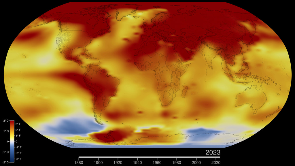
2023 Temperature Measurements
The locations of the temperature measurements that were used in the 2023 GISS Surface Temperature Analysis (v4). The data on land comes from the weather stations that make up the Global Historical Climatology Network (GHCN). Over water temperature measurements come from International Comprehensive Ocean-Atmosphere Data Set (ICOADS).
The locations of the temperature measurements that were used in the 2023 GISS Surface Temperature Analysis (v4). The data on land comes from the weather stations that make up the Global Historical Climatology Network (GHCN). Over water temperature measurements come from International Comprehensive Ocean-Atmosphere Data Set (ICOADS). This dataset provides surface marine observational records from ships, buoys, and other platform types.
This visualizarion is in an equirectangular projection optimised for spherical displays such as Science On a Sphere. The locations of the temperature measurements that were used in the 2023 GISS Surface Temperature Analysis (v4). The data on land comes from the weather stations that make up the Global Historical Climatology Network (GHCN). Over water temperature measurements come from International Comprehensive Ocean-Atmosphere Data Set (ICOADS).
The file date.txt is a label file containing the animation time for each frame number
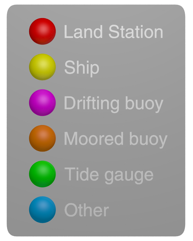
Legend showing the different types of temperature measurement platforms.
Credits
Please give credit for this item to:
NASA's Scientific Visualization Studio
-
Visualizer
- Mark SubbaRao (NASA/GSFC)
-
Technical support
- Laurence Schuler (ADNET Systems, Inc.)
- Ian Jones (ADNET Systems, Inc.)
-
Science advisor
- Peter H. Jacobs (NASA/GSFC)
Release date
This page was originally published on Friday, January 12, 2024.
This page was last updated on Wednesday, May 1, 2024 at 12:18 AM EDT.
Datasets used in this visualization
-
GISTEMP [GISS Surface Temperature Analysis (GISTEMP)]
ID: 585The GISS Surface Temperature Analysis version 4 (GISTEMP v4) is an estimate of global surface temperature change. Graphs and tables are updated around the middle of every month using current data files from NOAA GHCN v4 (meteorological stations) and ERSST v5 (ocean areas), combined as described in our publications Hansen et al. (2010) and Lenssen et al. (2019).
Credit: Lenssen, N., G. Schmidt, J. Hansen, M. Menne, A. Persin, R. Ruedy, and D. Zyss, 2019: Improvements in the GISTEMP uncertainty model. J. Geophys. Res. Atmos., 124, no. 12, 6307-6326, doi:10.1029/2018JD029522.
This dataset can be found at: https://data.giss.nasa.gov/gistemp/
See all pages that use this dataset -
ICOADS (International Comprehensive Ocean-Atmosphere Data Set)
ID: 1202The International Comprehensive Ocean-Atmosphere Data Set (ICOADS) offers surface marine data spanning 1662-present, and simple gridded monthly summary products for 2° latitude x 2° longitude boxes back to 1800 (and 1°x1° boxes since 1960)—these data and products are freely distributed worldwide. As it contains observations from many different observing systems encompassing the evolution of measurement technology over hundreds of years, ICOADS is probably the most complete and heterogeneous collection of surface marine data in existence.
Credit: Freeman, E.; Woodruff, S. D.; Worley, S. J.; Lubker, S. J.; Kent, E. C.; Angel, W. E.; Berry, D. I.; Brohan, P.; Eastman, R.; Gates, L.; Gloeden, W.; Ji, Z.; Lawrimore, J.; Rayner, N. A.; Rosenhagen; G. and Smith, S. R. (2016):International Comprehensive Ocean-Atmosphere Data Set (ICOADS) Release 3.0 - Monthly Summary Groups (MSG), Revision 3.0. NOAA National Centers for Environmental Information (NCEI).
This dataset can be found at: https://icoads.noaa.gov/
See all pages that use this dataset -
GHCNm (Global Historical Climatology Network monthly)
ID: 1203The Global Historical Climatology Network monthly (GHCNm) dataset provides monthly climate summaries from thousands of weather stations around the world. The initial version was developed in the early 1990s, and subsequent iterations were released in 1997, 2011, and most recently in 2018. The period of record for each summary varies by station, with the earliest observations dating to the 18th century. Some station records are purely historical and are no longer updated, but many others are still operational and provide short time delay updates that are useful for climate monitoring. The current version (GHCNm v4) consists of mean monthly temperature data, as well as a beta release of monthly precipitation data.
Credit: Menne, M. J., C. N. Williams, B.E. Gleason, J. J Rennie, and J. H. Lawrimore, 2018: The Global Historical Climatology Network Monthly Temperature Dataset, Version 4. J. Climate, in press. doi:10.1175/JCLI-D-18-0094.1
This dataset can be found at: https://www.ncei.noaa.gov/products/land-based-station/global-historical-climatology-network-monthly
See all pages that use this dataset
Note: While we identify the data sets used in these visualizations, we do not store any further details, nor the data sets themselves on our site.
Related
- ID: 5207
 Visualization
 - ID: 5060
 Visualization
 - ID: 4964
 Visualization