SOFIA Map of Water Near the Moon's South Pole
The virtual camera flies toward the Moon, visualized as it appeared on February 17, 2022, then scans south over the area of the SOFIA observations, shown in shades of blue (stronger water signal) and brown. Includes a color key and latitude-longitude grid near the South Pole.
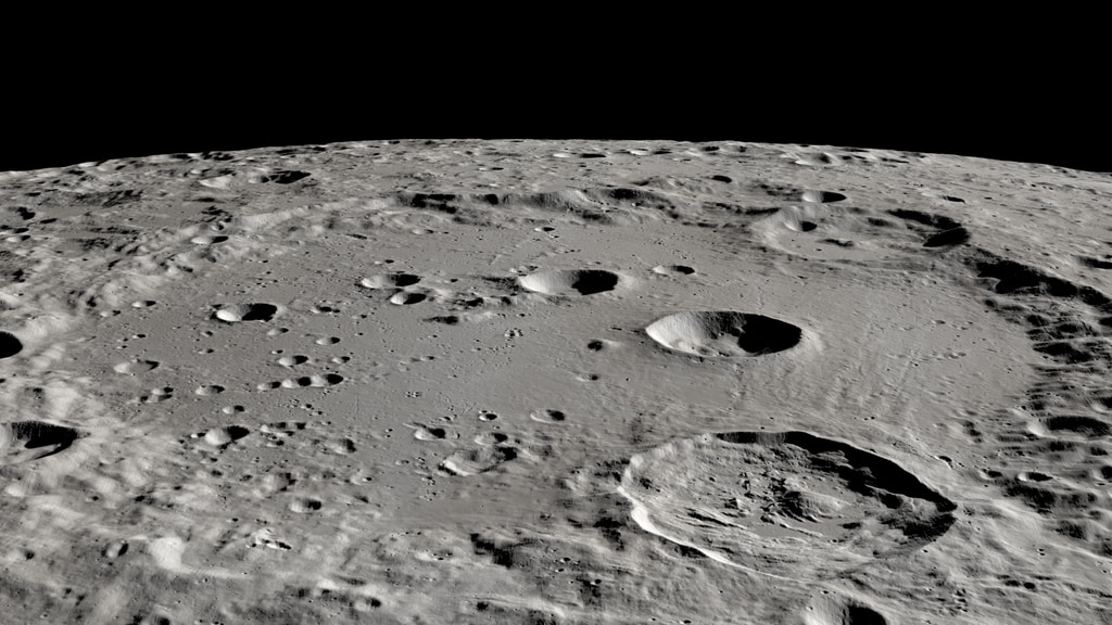
A study using the Stratospheric Observatory for Infrared Astronomy (SOFIA) has assembled the first detailed, wide-area map of water distribution on the Moon. The map covers a region on the eastern side of the Earth-facing hemisphere of the Moon from about 60°S latitude to the South Pole. The map shows higher concentrations of water on the shady poleward sides of craters and peaks far from the South Pole.
The media on this page show a visualization of the Moon as it appeared on the date of the SOFIA observations (February 17, 2022), overlaid with the water concentration map. Combining the map with an accurately illuminated model of the lunar terrain clearly shows the correspondence between the water concentration and the shadowed areas of the surface. Blue areas on the map indicate places that returned a stronger water signature in the 6.1μm band as detected by SOFIA's FORCAST short-wavelength infrared camera. The movies are provided in both landscape and portrait aspect ratios, with and without the color key, along with the rendered animation frames, stills, and the color key as a separate element.
The virtual camera flies toward the Moon, visualized as it appeared on February 17, 2022, then scans south over the area of the SOFIA observations, shown in shades of blue (stronger water signal) and brown. This is the animation as rendered, without the color key. The frames are in high dynamic range OpenEXR format with alpha.
The virtual camera flies toward the Moon, visualized as it appeared on February 17, 2022, then scans south over the area of the SOFIA observations, shown in shades of blue (stronger water signal) and brown. This is an alternate rendering, without the color key and South Pole grid. The frames are in high dynamic range OpenEXR format with alpha.
The virtual camera flies toward the Moon, visualized as it appeared on February 17, 2022, then scans south over the area of the SOFIA observations, shown in shades of blue (stronger water signal) and brown. Includes a color key and latitude-longitude grid near the South Pole. This is a vertical aspect ratio version.
The virtual camera flies toward the Moon, visualized as it appeared on February 17, 2022, then scans south over the area of the SOFIA observations, shown in shades of blue (stronger water signal) and brown. This is the animation as rendered, without the color key. The frames are in high dynamic range OpenEXR format with alpha. This is a vertical aspect ratio version.
The virtual camera flies toward the Moon, visualized as it appeared on February 17, 2022, then scans south over the area of the SOFIA observations, shown in shades of blue (stronger water signal) and brown. This is an alternate rendering, without the color key and South Pole grid. The frames are in high dynamic range OpenEXR format with alpha. This is a vertical aspect ratio version.

A still image of the ful disk of the Moon as it appeared on February 17, 2022. The region of the SOFIA observations is shown in shades of blue and brown.
A still image of the Moon and the northern portion of the SOFIA water data.
A still image of the Moon and the southern portion of the SOFIA data.
The color key. Blue shades indicate a stronger water signal in the 6.1μm infrared band.
For More Information
Credits
Please give credit for this item to:
NASA's Scientific Visualization Studio
-
Visualizer
- Ernie Wright (USRA)
-
Producers
- Kayvon E. Sharghi (ARC-DO)
- Abby Tabor (Wyle Labs)
-
Scientists
- William Reach (Universites Space Research Association (USRA))
- Casey Honniball (USRA)
-
Writer
- Anashe Bandari (Universities Space Research Association (USRA))
-
Technical support
- Laurence Schuler (ADNET Systems, Inc.)
- Ian Jones (ADNET Systems, Inc.)
Release date
This page was originally published on Wednesday, March 15, 2023.
This page was last updated on Wednesday, November 15, 2023 at 12:20 AM EST.
Papers used in this visualization
Datasets used in this visualization
-
DEM (Digital Elevation Map) [LRO: LOLA]
ID: 653 -
LROC WAC Color Mosaic (Natural Color Hapke Normalized WAC Mosaic) [Lunar Reconnaissance Orbiter: LRO Camera]
ID: 1015This natural-color global mosaic is based on the 'Hapke normalized' mosaic from LRO's wide-angle camera. The data has been gamma corrected, white balanced, and range adjusted to more closely match human vision.
See all pages that use this dataset
Note: While we identify the data sets used in these visualizations, we do not store any further details, nor the data sets themselves on our site.
Related
- ID: 4868
 Visualization