Dixie and Caldor Wildfires Locator Maps - 2021

Perimeters of Dixie and Caldor wildfires located in California. The extent of the Dixie wildfire is as of October 22, 2021, while the extent of the Caldor wildfire is as of October 6, 2021. The dropdown menu offers multiple resolutions for a 32:27 aspect ratio.
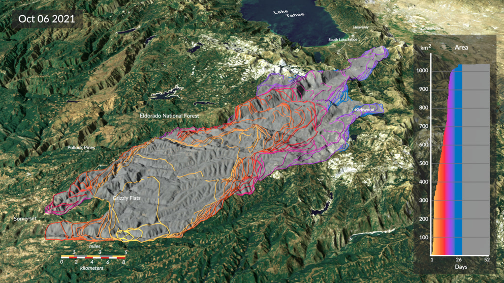
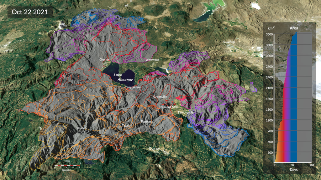
This map illustrates perimeter data for two California wildfires and allows for the comparison of their size and position. The data is derived from a new automatic fire detection and tracking approach (Chen et al., 2022) based on near-real time active fire detections from the VIIRS sensor on the Suomi-NPP satellite. The tracking system’s algorithm uses new active fire detections to update the total fire perimeter and estimate the position of active fire lines every 12 hours.
The Dixie wildfire, the northern most of the two, was the largest fire in California history with a total area (1,505 sq. miles) just above the size of U.S. state Rhode Island (1,214 sq. miles). In total, the Dixie fire burned for more than 100 days and this map displays the total extent between July 14 and October 22, 2021. The Caldor wildfire, east of Sacramento, is the second fire in California history to cross the Sierra Nevada Mountains. In total, the Caldor fire burned for more than 80 days through the El Dorado National Forest, threatening the communities of Meyers and South Lake Tahoe.
For more details, see the paper here.
Perimeters of Dixie and Caldor wildfires located in California with the state of Rhode Island for size comparison. The extent of the Dixie wildfire is as of October 22, 2021, while the extent of the Caldor wildfire is as of October 6, 2021. The dropdown menu offers multiple resolutions for a 32:27 aspect ratio.
Perimeter of the Dixie wildfire as of October 22, 2021. The dropdown menu offers multiple resolutions for a 32:27 aspect ratio.
Perimeter of the Dixie wildfire as of October 22, 2021, with the state of Rhode Island for size comparison. The dropdown menu offers multiple resolutions for a 32:27 aspect ratio.
Perimeter of the Caldor wildfire as of October 6, 2021. The dropdown menu offers multiple resolutions for a 32:27 aspect ratio.
Perimeters of Dixie and Caldor wildfires located in California. The extent of the Dixie wildfire is as of October 22, 2021, while the extent of the Caldor wildfire is as of October 6, 2021. The dropdown menu offers multiple resolutions for a 16:9 aspect ratio.
Perimeters of Dixie and Caldor wildfires located in California with the state of Rhode Island for size comparison. The extent of the Dixie wildfire is as of October 22, 2021, while the extent of the Caldor wildfire is as of October 6, 2021. The dropdown menu offers multiple resolutions for a 16:9 aspect ratio.
Perimeter of the Dixie wildfire as of October 22, 2021. The dropdown menu offers multiple resolutions for a 16:9 aspect ratio.
Perimeter of the Dixie wildfire as of October 22, 2021, with the state of Rhode Island for size comparison. The dropdown menu offers multiple resolutions for a 16:9 aspect ratio.
Perimeter of the Caldor wildfire as of October 6, 2021. The dropdown menu offers multiple resolutions for a 16:9 aspect ratio.
Credits
Please give credit for this item to:
NASA's Scientific Visualization Studio
-
Scientist
- Doug C. Morton (NASA/GSFC)
-
Visualizers
- Michala Garrison (SSAI)
- Cindy Starr (Global Science and Technology, Inc.)
-
Technical support
- Ian Jones (ADNET Systems, Inc.)
- Laurence Schuler (ADNET Systems, Inc.)
Release date
This page was originally published on Wednesday, June 1, 2022.
This page was last updated on Wednesday, May 3, 2023 at 11:44 AM EDT.
Papers used in this visualization
Chen, Y., Hantson, S., Andela, N. et al. California wildfire spread derived using VIIRS satellite observations and an object-based tracking system. Sci Data 9, 249 (2022). https://doi.org/10.1038/s41597-022-01343-0
Datasets used in this visualization
-
DEM [SRTM: SIR-C]
ID: 481 -
North America Roads (Natural Earth: North America Roads)
ID: 968The 1:1,000,000 scale roads database for North America from Natural Earth: http://www.naturalearthdata.com/downloads/10m-cultural-vectors/roads/. This data is in the public domain. Terms of use: http://www.naturalearthdata.com/about/terms-of-use/.
See all pages that use this dataset -
Natural Earth: 1:10m Cultural Vectors - Populated Places
ID: 1089This dataset can be found at: https://www.naturalearthdata.com/downloads/10m-cultural-vectors/10m-populated-places/
See all pages that use this dataset -
Fire Events Data Suite (FEDS) GeoPackage (Fire Events Data Suite (FEDS) GeoPackage) [Suomi-NPP: VIIRS]
ID: 1146The authors used the Suomi-NPP VIIRS I-band fire location data product (VNP14IMGML, Collection 1 Version 4), the U.S. National Land Cover Database (NLCD 2016) and gridMET product27 dead fuel moisture to develop an automatic system to dynamically track the growth of all fire events at a regional scale.
Credit: Yang Chen, Stijn Hantson, Niels Andela, Shane R. Coffield, Casey A. Graff, Douglas C. Morton, Lesley E. Ott, Efi Foufoula-Georgiou, Padhraic Smyth,
This dataset can be found at: https://figshare.com/s/0a68d4f2fbf5dc82930e
See all pages that use this dataset -
MRLC NLCD (Multi-Resolution Land Characteristics (MRLC) consortium National Land Cover Database (NLCD))
ID: 1147The National Land Cover Database (NLCD) provides nationwide data on land cover and land cover change at a 30m resolution with a 16-class legend based on a modified Anderson Level II classification system.
This dataset can be found at: https://www.mrlc.gov/
See all pages that use this dataset -
Natural Earth (Natural Earth)
ID: 1148Natural Earth is a public domain map dataset available at 1:10m, 1:50m, and 1:110 million scales. Featuring tightly integrated vector and raster data, with Natural Earth you can make a variety of visually pleasing, well-crafted maps with cartography or GIS software.
This dataset can be found at: https://www.naturalearthdata.com/
See all pages that use this dataset
Note: While we identify the data sets used in these visualizations, we do not store any further details, nor the data sets themselves on our site.
Related
- ID: 4992
 Visualization
 - ID: 4993
 Visualization
 - ID: 31184
 Hyperwall Visual