May 15-16, 2022 Total Lunar Eclipse: Visibility Map
An animated map showing where the May 15-16, 2022 lunar eclipse is visible. Contours mark the edge of the visibility region at eclipse contact times. The map is centered on 63°52'W, the sublunar longitude at mid-eclipse.
Also see the shadow diagram and Dial-a-Moon for this eclipse.
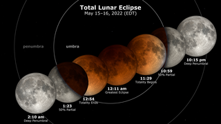
On May 16, 2022 (the night of May 15 in the Western Hemisphere), the Moon enters the Earth's shadow, creating a total lunar eclipse, the first since May of 2021. This animation shows the region of the Earth where this eclipse is visible. This region shifts to the west during the eclipse. Observers near the edge of the visibility region may see only part of the eclipse because for them, the Moon sets (on the eastern or right-hand edge) or rises (on the western or left-hand edge) while the eclipse is happening.
Contour lines mark the edge of the visibility region at the contact times. These are the times when the Moon enters or leaves the umbra (the part of the Earth's shadow where the Sun is completely hidden) and penumbra (the part where the Sun is only partially blocked). For observers located on a contour line, the contact occurs at moonrise (west) or moonset (east).

A map showing where the May 15-16, 2022 lunar eclipse is visible. Contours mark the edge of the visibility region at eclipse contact times. The map is centered on 63°52'W, the sublunar longitude at mid-eclipse.
The mask defining the visibility region, centered at 0° longitude.
Credits
Please give credit for this item to:
NASA's Scientific Visualization Studio
-
Visualizer
- Ernie Wright (USRA)
-
Technical support
- Laurence Schuler (ADNET Systems, Inc.)
- Ian Jones (ADNET Systems, Inc.)
Release date
This page was originally published on Thursday, March 24, 2022.
This page was last updated on Wednesday, November 15, 2023 at 12:18 AM EST.
Missions
This visualization is related to the following missions:Series
This visualization can be found in the following series:Datasets used in this visualization
-
Earth at Night [DMSP: OLS]
ID: 286 -
DE421 (JPL DE421)
ID: 752Planetary ephemerides
This dataset can be found at: http://ssd.jpl.nasa.gov/?ephemerides#planets
See all pages that use this dataset
Note: While we identify the data sets used in these visualizations, we do not store any further details, nor the data sets themselves on our site.
Related
- ID: 14151
- ID: 4980
 Visualization
 - ID: 4979
 Visualization