The Moon's Clavius Crater
A slow flyover of Clavius crater, looking south.
Clavius is among the largest and oldest craters on the Moon. Located in the far southern area of the Moon's near side, it's visible in binoculars and small telescopes between first and third quarter phases. It's perhaps best known as the site of the fictional Moon base in Stanley Kubrick's movie 2001: A Space Odyssey.
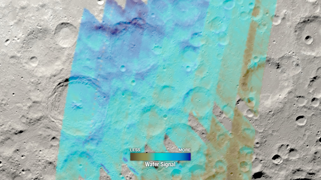
It's also now the site of a somewhat surprising discovery of water on the Moon.
The discovery was published in the October 26, 2020 edition of Nature Astronomy. Lead author Casey Honniball, a postdoctoral fellow at NASA Goddard Space Flight Center, and her co-authors used the airborne infrared telescope SOFIA to detect the characteristic signature of water molecules in the floor of Clavius. Molecules containing hydrogen and oxygen have been found in many previous observations, and these strongly implied the presence of water, but the SOFIA observations found emissions at a wavelength specific to H2O (water) and not hydroxyl (OH) compounds.
At 100 to 400 parts per million of water, Clavius is still much drier than the driest deserts on Earth. But the crater is far from the permanently shadowed regions of the lunar poles, where water ice can be protected from evaporating, so the presence of any amount of water there is a puzzle that awaits explanation.
The visualization on this page is a slow flyover of Clavius as it might be seen by astronauts in orbit. It uses surface color and elevation maps of the Moon generated from Lunar Reconnaissance Orbiter data.
For More Information
Credits
Please give credit for this item to:
NASA's Scientific Visualization Studio
-
Visualizer
- Ernie Wright (USRA)
-
Technical support
- Laurence Schuler (ADNET Systems, Inc.)
- Ian Jones (ADNET Systems, Inc.)
Release date
This page was originally published on Monday, October 26, 2020.
This page was last updated on Thursday, February 22, 2024 at 12:13 AM EST.
Series
This visualization can be found in the following series:Papers used in this visualization
C. Honniball et al., Molecular water detected on the sunlit Moon by SOFIA, Nature Astronomy, 26 Oct 2020
Datasets used in this visualization
-
SLDEM2015 (DIgital Elevation Model) [LRO/SELENE: LOLA/TC]
ID: 948A digital elevation model of the Moon derived from the Lunar Orbiter Laser Altimeter and the SELENE Terrain Camera. See the description in Icarus. The data is here.
See all pages that use this dataset -
LROC WAC Color Mosaic (Natural Color Hapke Normalized WAC Mosaic) [Lunar Reconnaissance Orbiter: LRO Camera]
ID: 1015This natural-color global mosaic is based on the 'Hapke normalized' mosaic from LRO's wide-angle camera. The data has been gamma corrected, white balanced, and range adjusted to more closely match human vision.
See all pages that use this dataset
Note: While we identify the data sets used in these visualizations, we do not store any further details, nor the data sets themselves on our site.
Related
- ID: 14529

- ID: 5092
 Visualization