OSIRIS-REx – Detailed Global Views of Asteroid Bennu
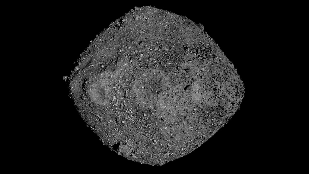
Looping animation of asteroid Bennu rotating. This 3D model of Bennu was created using 20cm resolution laser altimetry data and imagery taken by OSIRIS-REx.
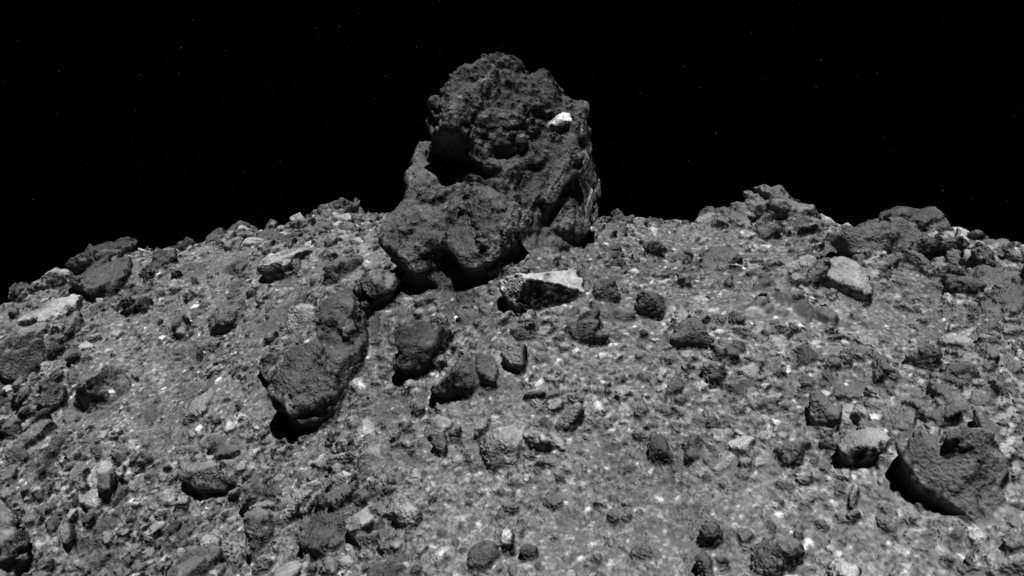
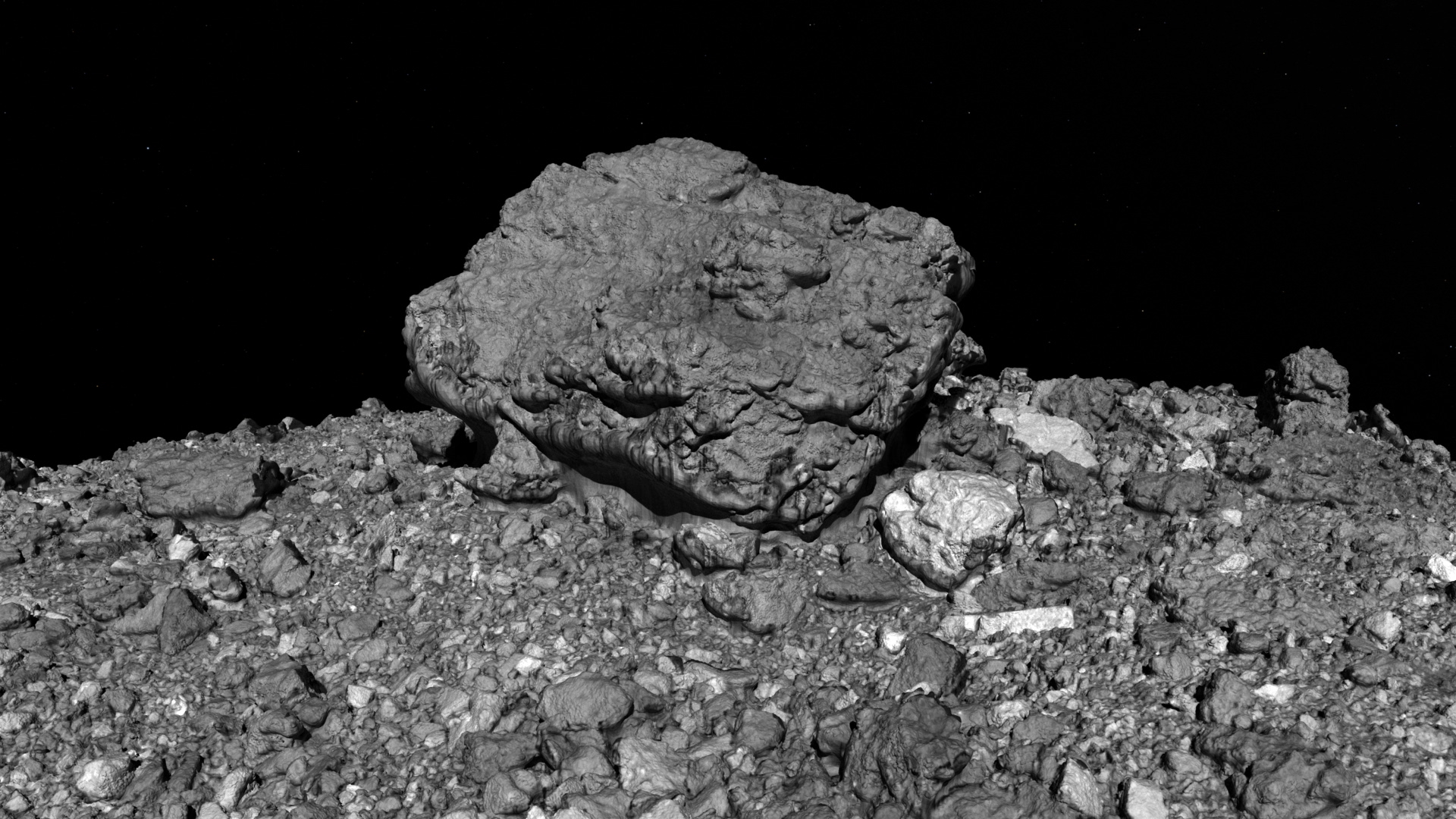
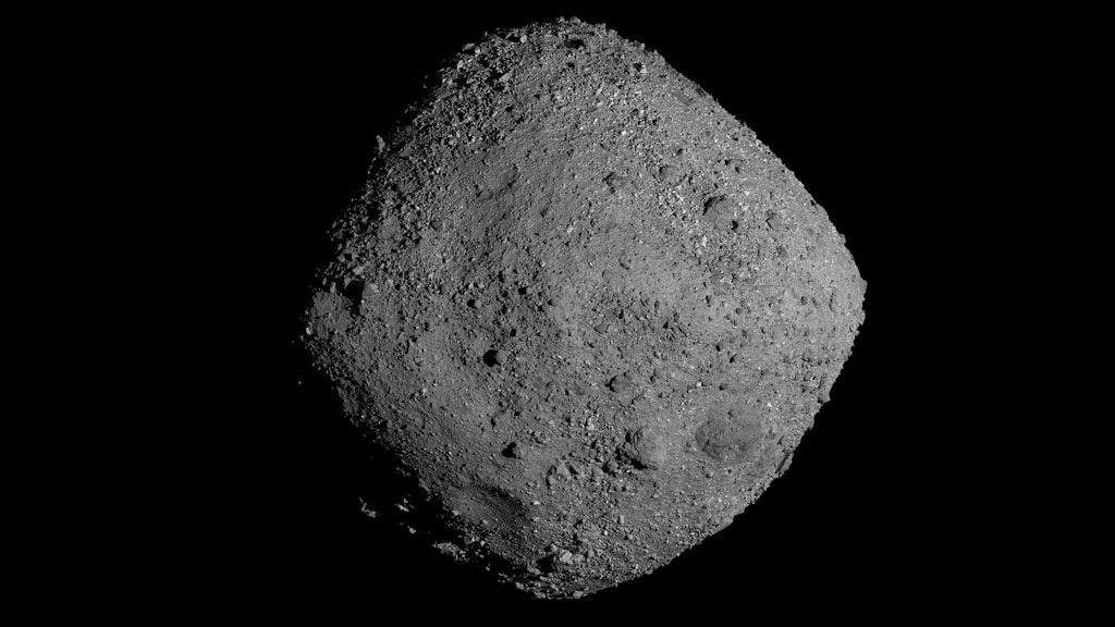
When NASA’s OSIRIS-REx spacecraft arrived at asteroid Bennu in December 2018, its close-up images confirmed what mission planners had predicted nearly two decades before: Bennu is made of loose material weakly clumped together by gravity, and shaped like a spinning top. This major validation, however, was accompanied by a major surprise. Scientists had expected Bennu’s surface to consist of fine-grained material like a sandy beach, but instead OSIRIS-REx was greeted by a rugged world littered with boulders – the size of cars, the size of houses, the size of football fields.
The 3D animations on this page were created using laser altimetry data and imagery of Bennu taken by OSIRIS-REx.
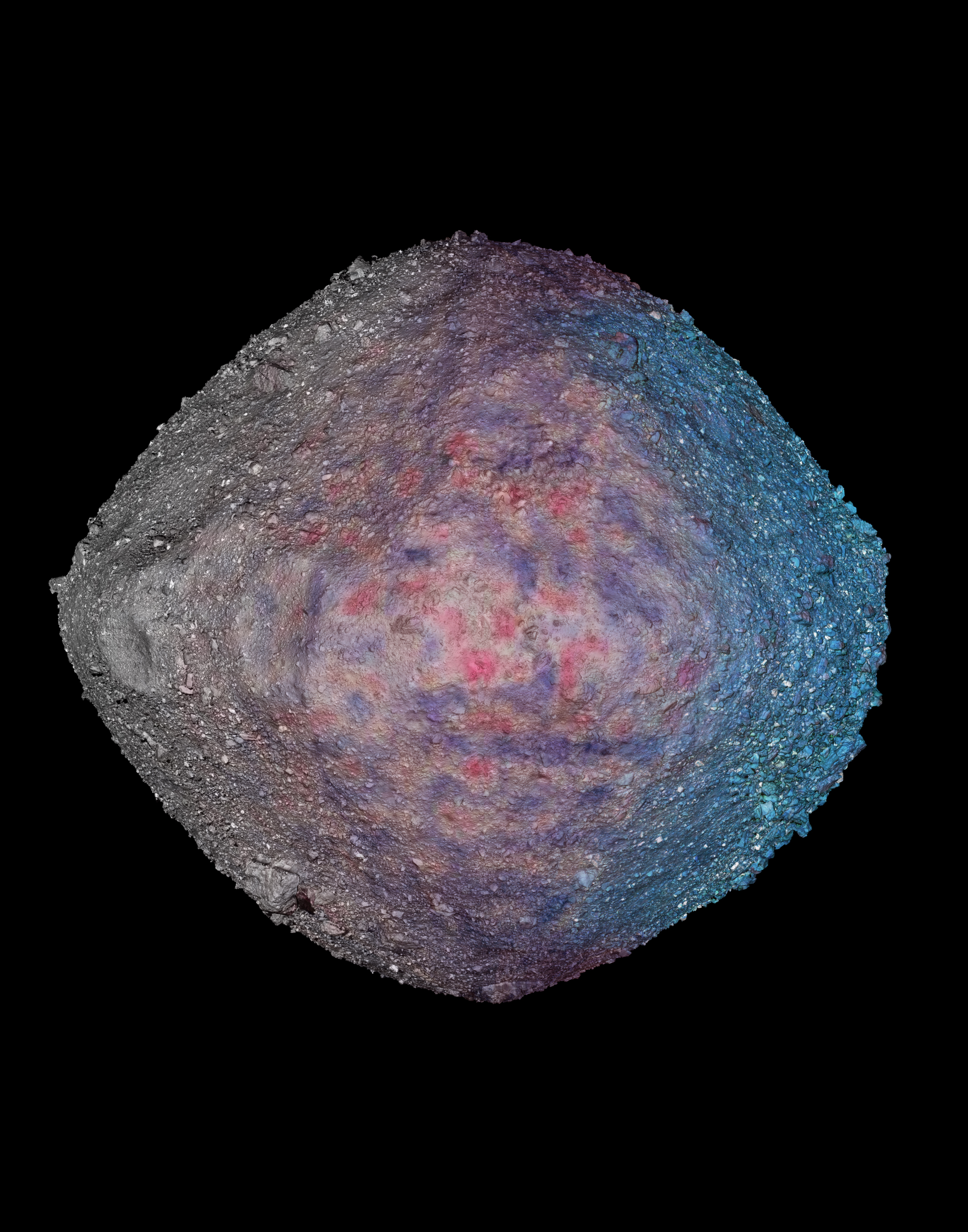
The Bennu albedo map was generated using images acquired by PolyCam during Baseball Diamond Flyby 1. The images were photometrically normalized to represent the innate albedo of Bennu’s surface. Details for the creation of the map can be found in the forthcoming publication “A High-Resolution Normal Albedo Map of Asteroid (101955) Bennu” by Golish et al. Icarus (2020).
Polar regions that were not imaged in Flyby 1 are visualized using the Bennu global basemap, created from PolyCam images acquired during Baseball Diamond Flybys 3 and 4. Details for the creation of the basemap can be found in “A high-resolution global Basemap of (101955) Bennu” by Bennett et al. Icarus (2020).
Looping animation of sunlight sweeping across the surface of Bennu. This 3D model of Bennu was created using 20cm resolution laser altimetry data and imagery taken by OSIRIS-REx.

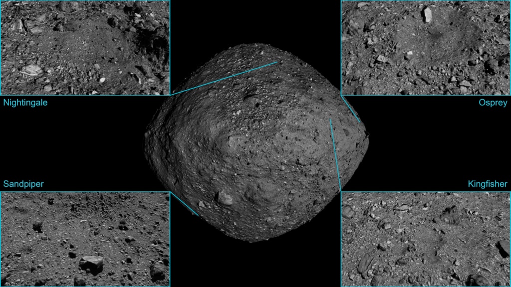
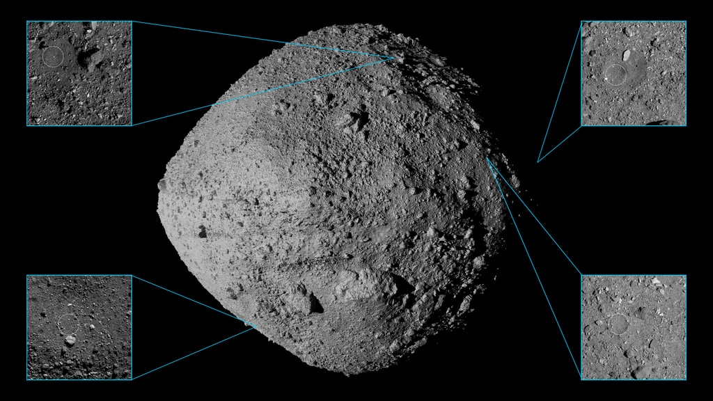
Print resolution (5760x3240 pixels) still image of Bennu. The Nightingale sample site is visible in the northern hemisphere.
Print resolution (5760x3240 pixels) still image of Bennu
Print resolution (5760x3240 pixels) still image of Bennu
Print resolution (5760x3240 pixels) still image of Bennu
Print resolution (5760x3240 pixels) still image of Bennu
Print resolution (5760x3240 pixels) still image of Bennu
Print resolution (5760x3240 pixels) still image of Bennu
Print resolution (5760x3240 pixels) still image of Bennu
Credits
Please give credit for this item to:
NASA's Scientific Visualization Studio
Data provided by NASA/University of Arizona/CSA/York University/MDA.
-
Visualizer
- Kel Elkins (USRA)
-
Producer
- Dan Gallagher (USRA)
-
Communications
- Erin Morton (The University of Arizona)
- Nancy Neal-Jones (NASA/GSFC)
- Cat Wolner (The University of Arizona/LPL)
-
Technical support
- Ian Jones (ADNET Systems, Inc.)
- Eric Sokolowsky (Global Science and Technology, Inc.)
-
Scientist
- Dathon Golish (The University of Arizona/LPL)
Release date
This page was originally published on Monday, September 21, 2020.
This page was last updated on Tuesday, April 23, 2024 at 12:15 AM EDT.
Missions
This visualization is related to the following missions:Datasets used in this visualization
-
LIDAR [OSIRIS-REx: OLA]
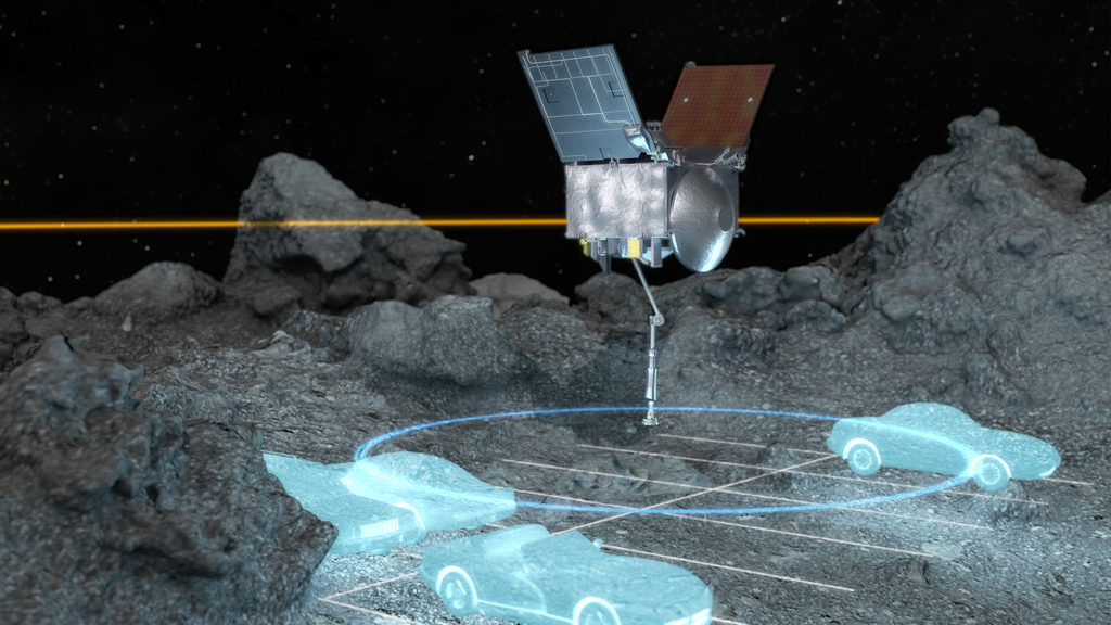
ID: 1055The OSIRIS-REx Laser Altimeter (OLA) is a scanning LIDAR (Light Detection and Ranging). LIDAR is similar to RADAR, but it uses light instead of radio waves to measure distance. OLA emitted laser pulses at the surface of Bennu, which reflected back from the surface and returned a portion of the laser pulse to the LIDAR detector. By carefully measuring the time difference between the outgoing pulse and the incoming pulse, the distance from the spacecraft to the surface of Bennu was computed using the speed of light. This allowed OLA to provide high-resolution topographical information about Bennu during the mission.
See all pages that use this dataset -
Imagery [OSIRIS-REx: OCAMS]
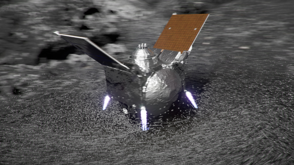
ID: 1063The OSIRIS-REx Camera Suite (OCAMS) consists of three cameras: PolyCam, MapCam, and SamCam. These cameras captured a wealth of imagery during OSIRIS-REx’s time at asteroid Bennu. To help mission planners select a site on Bennu for sample collection, OCAMS provided global image mapping of the asteroid’s surface and more detailed images of potential sample sites. OCAMS also recorded the sampling event during the touch-and-go (TAG) maneuver.
Credit: NASA/University of Arizona/CSA/York University/MDA
See all pages that use this dataset
Note: While we identify the data sets used in these visualizations, we do not store any further details, nor the data sets themselves on our site.
Related
- ID: 14415
 Produced Video
 - ID: 14387
- ID: 14406
![Ride along with OSIRIS-REx during the thrilling finale of its journey to Bennu and back.Complete transcript available.Universal Production Music: “A Sense of Urgency” and “Rise to the Challenge” by Daniel Marantz and Michael James Burns, Raydia Music library [PRS]; “Fragments of Time” by Timothy Robert Shortell, Scores of Hypersonic Music [BMI]Watch this video on the NASA Goddard YouTube channel.](/vis/a010000/a014400/a014406/OSIRIS-REx_Journeys_End_Preview_V3_print.jpg) Produced Video
Produced Video - ID: 5133
 Visualization
 - ID: 5010
 Visualization
 - ID: 4921
 Visualization
 - ID: 13849

- ID: 4886
 Visualization
 - ID: 4862
 Visualization
 - ID: 13731

- ID: 4863
 Visualization
 - ID: 13729
 Produced Video
 - ID: 20323
- ID: 13565
 Produced Video
 - ID: 13489
 Produced Video
 - ID: 4771
- ID: 13504
![NASA Science Live: OSIRIS-REx - X Marks the Spot [Episode 13]Air Date: December, 12, 2019Watch this video on the ScienceAtNASA YouTube channel.](/vis/a010000/a013500/a013504/NSL_ep13_still_print.jpg)
- ID: 4744
Older Versions
- ID: 4795

Used as a Source In
- ID: 12976
 Produced Video
 - ID: 14179
 Produced Video
 - ID: 13730
 Produced Video