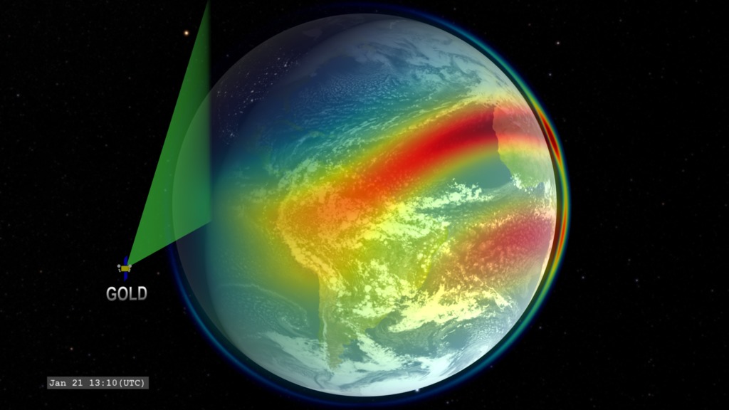
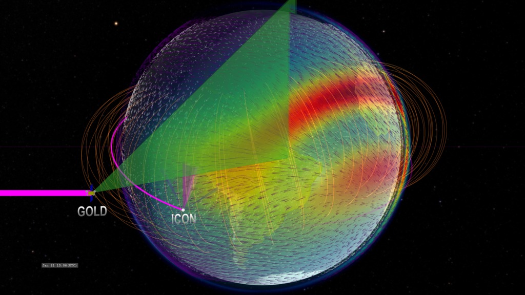
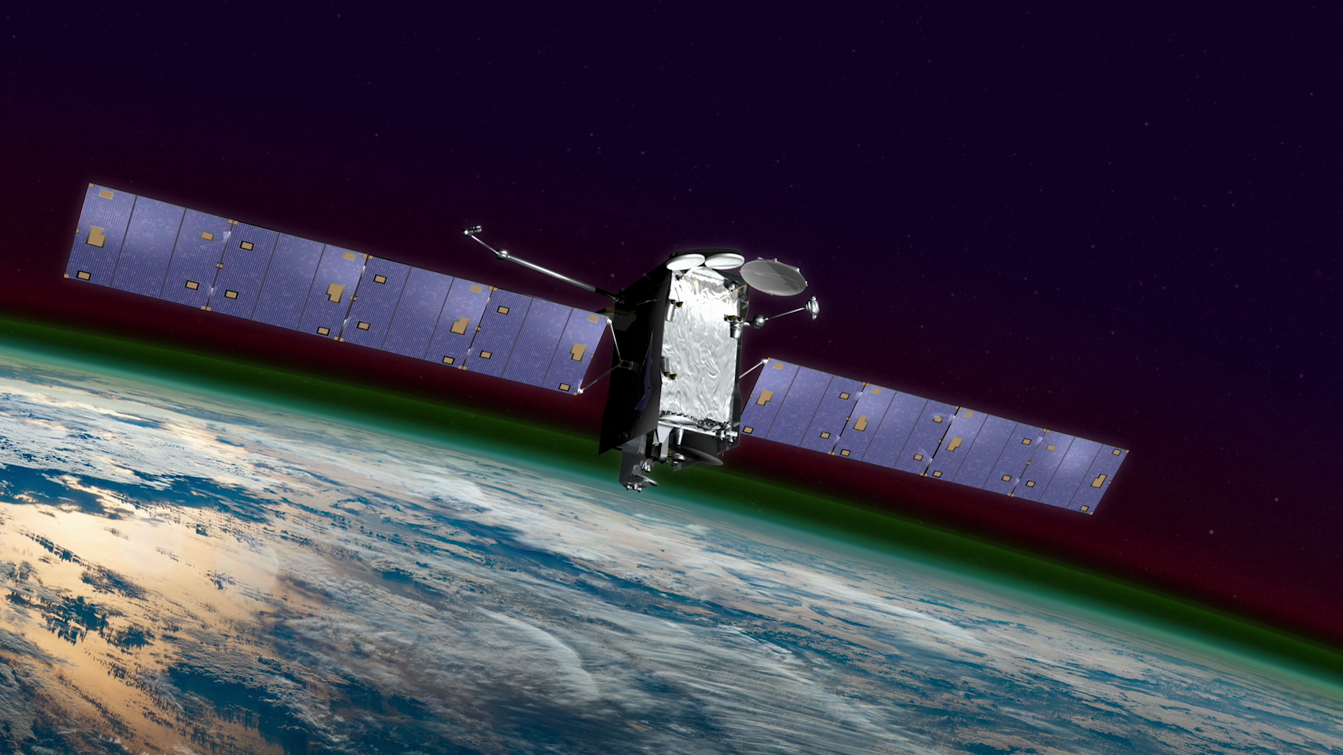
GOLD in Geostationary Orbit
- Visualizations by:
- Tom Bridgman
- View full credits
Movies
- IRIDaily.oblique_GOLD.HD1080i_p30.mp4 (1920x1080)
- IRIDaily.oblique_GOLD.HD1080i_p30.webm (1920x1080)
- IRIDaily.oblique_GOLD.UHD3840_2160p30.mp4 (3840x2160)
Images
- IRIDaily.oblique_.noslate_CRTT.HD1080i.000450_print.jpg (1024x576)
- IRIDaily.oblique_.noslate_CRTT.HD1080i.000450_thm.png (80x40)
- IRIDaily.oblique_.noslate_CRTT.HD1080i.000450_searchweb.png (320x180)
Frames
- frames/1920x1080_16x9_30p/ (1920x1080)
- frames/3840x2160_16x9_30p/ (3840x2160)
Right click movies to download them if they automatically play in your browser.
The GOLD instrument orbits Earth in a geostationary orbit over the western hemisphere.
GOLD will scan the disk and limb of Earth with an ultraviolet imaging spectrograph to measure the response of Earth's ionosphere to the various forcings in the Sun-Earth system.
Credits
Please give credit for this item to:
NASA's Scientific Visualization Studio
Visualizer
- Tom Bridgman (GST) [Lead]
Writer
- Kathalina Tran (SGT)
Scientist
- Sarah L. Jones (NASA/GSFC)
Producers
- Genna Duberstein (ADNET)
- Joy Ng (KBRwyle)
Technical support
- Ian Jones (ADNET)
- Laurence Schuler (ADNET)
Missions
This visualization is related to the following missions:Series
This visualization can be found in the following series:Related pages
Observing Earth's Ionosphere with GOLD
July 17, 2019, 7 a.m.
Read moreThis is a visualization of data taken by the GOLD spectrometer aboard the SES-14 satellite. SES 14 is positioned in a geostationary orbit above 47.5 degrees west longitude so it always observes the same hemisphere. This data is of ultraviolet emission from Earth s ionosphere in ultraviolet light also indicating the structure of the low-latitude geomagnetic field (gold curves). Color bar for GOLD radiance values near oxygen emission line. For More InformationSee [NASA Mission Page](https://www.nasa.gov/content/goddard/gold)
GOLD Resources
Jan. 24, 2018, 7 a.m.
Read moreThe Global-scale Observations of the Limb and Disk, or GOLD, mission is designed to explore the nearest reaches of space. Capturing never-before-seen images of Earth’s upper atmosphere, GOLD explores in unprecedented detail our space environment — which is home to astronauts, radio signals used to guide airplanes and ships, as well as satellites that provide communications and GPS systems. The more we know about the fundamental physics of this region of space, the more we can protect our assets there.Gathering observations from geostationary orbit above the Western Hemisphere, GOLD measures the temperature and composition of neutral gases in Earth’s thermosphere. This part of the atmosphere co-mingles with the ionosphere, which is made up of charged particles. Both the Sun from above and terrestrial weather from below can change the types, numbers, and characteristics of the particles found here — and GOLD helps track those changes.Activity in this region is responsible for a variety of key space weather events. GOLD scientists are particularly interested in the cause of dense, unpredictable bubbles of charged gas that appear over the equator and tropics, sometimes causing communication problems. As we discover the very nature of the Sun-Earth interaction in this region, the mission could ultimately lead to ways to improve forecasts of such space weather and mitigate its effects. Artist rendering of SES-14 satellite, the spacecraft that will carry GOLD as NASA s radiation, emitting light. By measuring the light from airglow, ICON and GOLD will learn a lot about the neutral and charged particles in the upper atmosphere. This infographic compares the GOLD and ICON missions, which together will provide the most ever comprehensive observations of the ionosphere.A PDF is available to download at the bottom of the page. Credit: Mary P. Hrybyk-KeithThis infographic compares the GOLD and ICON missions, which together will provide the most ever comprehensive observations of the ionosphere.A PDF is available to download at the bottom of the page. Credit: Mary P. Hrybyk-Keith Part 1/2: A flyer with information on the GOLD mission’s science goals, instrument and orbit.A PDF is available to download at the bottom of the page. Credit: Mary P. Hrybyk-Keith Part 2/2: A flyer with information on the GOLD mission’s science goals, instrument and orbit.A PDF is available to download at the bottom of the page.Credit: Mary P. Hrybyk-Keith Slug: NASA GOLD Mission to Image Earth’s Interface to SpaceOn Thursday, Jan. 25, 2018, the Global-scale Observations of the Limb and Disk, or GOLD, mission launches to explore Earth’s boundary to space. Capturing never-before-seen images of Earth’s upper atmosphere, GOLD will help us understand the region that is home to astronauts, radio signals used to guide airplanes and ships, as well as satellites that provide communications and GPS systems.TRT: 6:31Edited B-roll RT: :52Interview Excerpts RT: 1:02Additional B-Roll RT: 3:05Super(s): NASACenter Contact: Karen Fox, karen.c.fox@nasa.gov, 301-286-6284HQ Contact: Dwayne Brown, dwayne.c.brown@nasa.gov, 202-358-1726For more information: www.nasa.gov/GOLD For More InformationSee [https://www.nasa.gov/feature/goddard/2018/nasa-gold-mission-to-image-earth-s-interface-to-space](https://www.nasa.gov/feature/goddard/2018/nasa-gold-mission-to-image-earth-s-interface-to-space)
GOLD: Instrument Scanning Coverage
Jan. 19, 2018, 10 a.m.
Read moreA basic view of the orbit for GOLD (Global-scale Observations of the Limb and Disk). This mission will conduct measurements of ionospheric composition and ionization better understand the connection between space weather and its terrestrial impacts.In this visualization, we present GOLD in geostationary orbit around Earth. The colors over Earth represent model data from the IRI (International Reference Ionosphere) model of the density of the singly-ionized oxygen atom at an altitude of 350 kilometers. Red represents high density. The ion density is enhanced above and below the geomagnetic equator (not perfectly aligned with the geographic equator) on the dayside due to the ionizing effects of solar ultraviolet radiation combined with the effects of high-altitude winds and the geomagnetic field.In the latter half of the visualization, the viewing fields of the GOLD instrument are displayed. GOLD has an imaging spectrometer (green) that periodically scans the disk of Earth with additional higher-resolution scans of the dayside limb. Visualization of GOLD orbiting Earth with image scanning. This version presents the singly-ionized oxygen density from the IRI model.
ICON and GOLD: Instrument Scanning Coverage
Dec. 14, 2016, 9 a.m.
Read moreA basic view of the orbits for ICON (Ionospheric Connections Explorer) and GOLD (Global-scale Observations of the Limb and Disk). These missions will conduct measurements of ionospheric composition, ionization, and winds to better understand the connection between space weather and its terrestrial impacts.In this visualization, we present GOLD (in geostationary orbit around Earth) and ICON (in low Earth orbit). The colors over Earth represent model data from the IRI (International Reference Ionosphere) model of the density of the singly-ionized oxygen atom at an altitude of 350 kilometers. Red represents high density. The ion density is enhanced above and below the geomagnetic equator (not perfectly aligned with the geographic equator) on the dayside due to the ionizing effects of solar ultraviolet radiation combined with the effects of high-altitude winds and the geomagnetic field.In the latter half of the visualization, the viewing fields of the various instruments are displayed. ICON has an EUV (Extreme Ultraviolet) and FUV (Far Ultraviolet) cameras (violet colored frustrums directed from spacecraft) pointing perpendicular to the orbit direction for detecting ionospheric emissions. Two Doppler interferometer cameras (blue) are directed at 45 degrees from this camera to detect ionospheric wind velocities.GOLD has an imaging spectrometer (green) that periodically scans the disk of Earth with additional higher-resolution scans of the dayside limb. Visualization of ICON and GOLD orbiting Earth with image scanning. This version presents several geospace models, including the singly-ionized oxygen density, the low-latitude geomagnetic field, and the high-altitude winds (100km and 350km altitudes). Color bar of singly-ionized atomic oxygen density. Visualization of ICON and GOLD orbiting Earth with image scanning. This version presents several geospace models, including the singly-ionized oxygen density and the high-altitude winds (100km and 350km altitudes). Visualization of ICON and GOLD orbiting Earth with image scanning. This is an older version which is superceeded by the versions above.
Untitled
Feb. 5, 2018, 7 a.m.
Read moreNASA’s newest mission, GOLD, will explore the ever-changing boundary between Earth and space. GOLD explores the dynamic region where Earth’s uppermost atmosphere meets space. At geostationary orbit 22,000 miles over the Western Hemisphere, GOLD has a full-disk view of the upper atmosphere. The ionosphere is a region of charged particles in near-Earth space that coexists with the neutral atmosphere, called the thermosphere. Bright swaths of light in the atmosphere, called airglow, are seen in this photo of Earth’s limb shot from the International Space Station. GOLD teams up with NASA’s Ionospheric Connection Explorer - ICON - to provide the most comprehensive ionosphere observations we’ve ever had. For More InformationSee [NASA.gov](https://www.nasa.gov/feature/goddard/2018/nasa-gold-mission-to-image-earth-s-interface-to-space)
Why NASA Is Exploring The Edge Of Our Planet
Jan. 5, 2018, 8 a.m.
Read moreThe Global-scale Observations of the Limb and Disk, or GOLD, instrument launches aboard a commercial communications satellite in January 2018 to inspect the dynamic intermingling of space and Earth’s uppermost atmosphere. Together, GOLD and another NASA mission, Ionospheric Connection Explorer spacecraft, or ICON, will provide the most comprehensive of Earth’s upper atmosphere we’ve ever had.Above the ozone layer, the ionosphere is a part of Earth’s atmosphere where particles have been cooked into a sea of electrically-charged electrons and ions by the Sun’s radiation. The ionosphere is co-mingled with the very highest — and quite thin — layers of Earth’s neutral upper atmosphere, making this region an area that is constantly in flux undergoing the push-and-pull between Earth’s conditions and those in space. Increasingly, these layers of near-Earth space are part of the human domain, as it’s home not only to astronauts, but to radio signals used to guide airplanes and ships, and satellites that provide our communications and GPS systems. Understanding the fundamental processes that govern our upper atmosphere and ionosphere is crucial to improve situational awareness that helps protect astronauts, spacecraft and humans on the ground.GOLD, in geostationary orbit over the Western Hemisphere, will build up a full-disk view of the ionosphere and upper atmosphere every half hour, providing detailed large-scale measurements of related processes — a cadence which makes it the first mission to be able to monitor the true weather of the upper atmosphere. GOLD is also able to focus in on a tighter region and scan more quickly, to complement additional research plans as needed. Complete transcript available.Music credits: s radiation, emitting light. By measuring the light from airglow, ICON and GOLD will learn a lot about the neutral and charged particles in the upper atmosphere. For More InformationSee [https://www.nasa.gov/feature/goddard/2018/nasa-gold-mission-to-image-earth-s-interface-to-space](https://www.nasa.gov/feature/goddard/2018/nasa-gold-mission-to-image-earth-s-interface-to-space)