Flying Through LIDAR Canopy Data
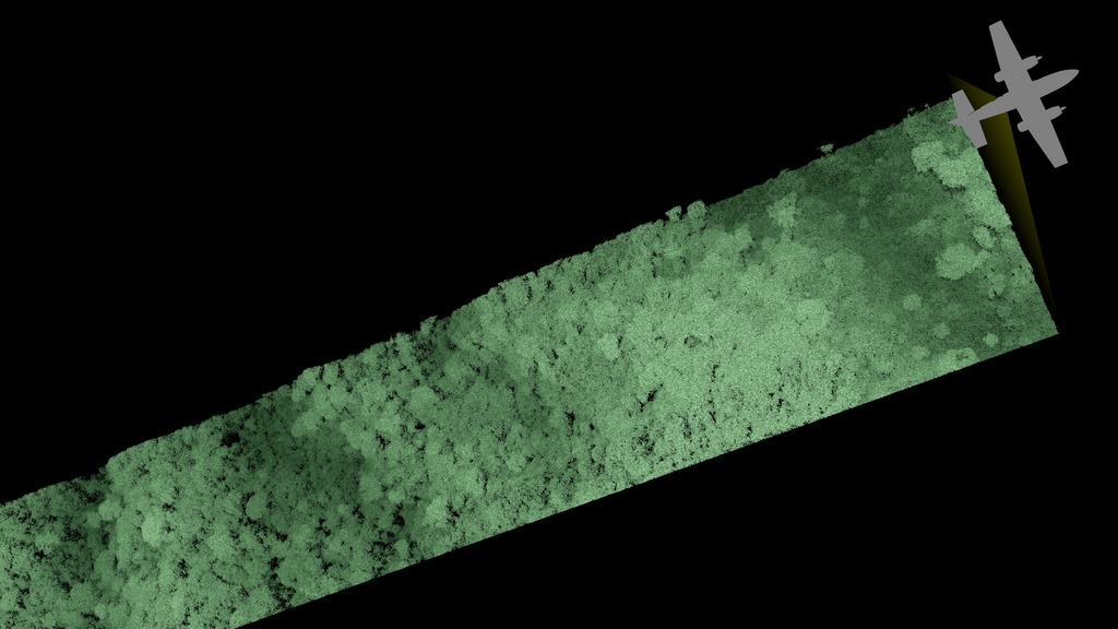
This animation shows an airplane collecting treetop data over a Brazilian rainforest. As the airplane continues to collect data, the viewer flies down to the rainforest canopy and flies through the virtual leaves, eventually emerging to see the airplane off in the distance still collecting new data. It should be noted that for the purposes of this animation, we chose to use leaf-like objects to represent each lidar data point in 3D space. However, lidar data does not specifically show individual leaves, but simply point heights reflected by the leaf canopy. However, the resolution of the lidar data is so good that it potentially can pick up leaves and other structures such as tree branches, and sometimes even flying birds, but has no easy way to differentiate between them. Therefore, since the location of this particular data was known to be a rainforest, and the majority of the data points would represent leaves, we chose leaf-like structures for this particular case.
This visualization shows the resolution of LIDAR (LIght Detection And Ranging) canopy data over the Brazilian Rainforest by flying a virtual camera down through the data. The full swath of data consists of approximately 1 billion data points, where each data point is a position in 3D space. Together these data points provide scientists with information on foliage distribution and the elements of tree canopy. Similar LIDAR technologies are used to measure terrain topographies on the Moon and Mars.
Credits
Please give credit for this item to:
NASA's Scientific Visualization Studio
-
Data visualizers
- Alex Kekesi (Global Science and Technology, Inc.)
- Greg Shirah (NASA/GSFC)
-
Scientists
- Doug C. Morton (NASA/GSFC)
- Veronika Leitold (University of Maryland)
-
Technical support
- Laurence Schuler (ADNET Systems, Inc.)
- Ian Jones (ADNET Systems, Inc.)
-
Data provider
- Hyeungu Choi (Global Science and Technology, Inc.)
Release date
This page was originally published on Tuesday, June 12, 2018.
This page was last updated on Wednesday, November 15, 2023 at 12:10 AM EST.
Series
This visualization can be found in the following series:Datasets used in this visualization
-
LiDAR (LiDAR 3D point cloud) [Airplane: G-LiHT]
ID: 965
Note: While we identify the data sets used in these visualizations, we do not store any further details, nor the data sets themselves on our site.
Related
- ID: 4530
 Visualization
 - ID: 4650
 Visualization
 - ID: 4651
 Visualization
 - ID: 4652

Used as a Source In
- ID: 12398
 Produced Video