Monitoring Chimpanzee Habitats in western Tanzania
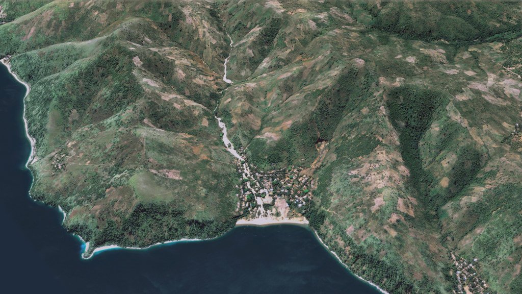
This visualization shows one location of the area in western Tanzania where the Jane Goodall Institute is working. After focusing on the region to the southeast of the Gombe National Park, this visualization shows the change in forest cover between 1972 and 1999. Forested areas are shown in shades of green; non-forested regions are shown in shades of brown.
In partnership with the Jane Goodall Institute (JGI), NASA scientists have provided assistance in the monitoring, forecasting and conservation of natural resources in regions surrounding the Gombe National Park in Tanzania. Between 1972 and 1999, significant deforestation had occurred in the regions outside the boundary of the Gombe National Park to the detriment of the park's chimpanzee population as well as to the that of the villagers living in the region.
In 2005, JGI initiated a forest monitoring program training and in 2009 equipped community members with GPS-enabled Android smart phones and tablets to report their observations on forests threats and wildlife. Combining NASA remote sensing data with citizen science observations facilitated local people to develop and implement land use plans, leading to improved decision making and facilitating the establishment of village forest reserves.
In 2016, the Metropolitan Group developed a 4.5-minute video detailing the story of this collaboration between NASA and JGI. The video shows footage of project activities in Tanzania along with planning meetings using DigitalGlobe and NASA satellite data. The animations shown here were developed to support this production. The complete video is available here.

A print resolution image comparing the forest cover change between 1972 and 1999 in the region around Gombe National Park.
This visualization shows the difference in the forest cover between the region within the Gombe National Park, to the left of the red boundary line, and the regions outside of the park to the right.
QuickBird imagery provided courtesy of DigitalGlobe. Processed by Chuck Chaapel.
A print resolution image showing the deforestation outside of the boundrary of Gombe National Park.
QuickBird imagery provided courtesy of DigitalGlobe. Processed by Chuck Chaapel.
This visualization pulls out from Tanzania to show global view of the planet.
A print resolution image of a global view of the Earth.
This visualization shows a subset of an orbit swath of the LandSat 8 satellite. The full animation is available here.
A print resolution image of a LandSat orbit.
Credits
Please give credit for this item to:
NASA's Scientific Visualization Studio
-
Visualizers
- Cindy Starr (Global Science and Technology, Inc.)
- Trent L. Schindler (USRA)
-
Scientist
- Lilian Pintea (The Jane Goodall Institute)
-
Producers
- Corinne Nakamura-Rybak (Metropolitan Group)
- Patrick Lynch (Wyle Information Systems)
- Jefferson Beck (USRA)
-
Project support
- Leann Johnson (Global Science and Technology, Inc.)
- Joycelyn Thomson Jones (NASA/GSFC)
-
Technical support
- Ian Jones (ADNET Systems, Inc.)
- Laurence Schuler (ADNET Systems, Inc.)
-
Editor
- Margaret Anderson (SkEye Studios)
Release date
This page was originally published on Wednesday, January 25, 2017.
This page was last updated on Tuesday, November 14, 2023 at 12:08 AM EST.
Missions
This visualization is related to the following missions:Datasets used in this visualization
-
[QuickBird]
ID: 84 -
NDVI [Landsat: MSS]
ID: 937 -
NDVI [Landsat: ETM]
ID: 938
Note: While we identify the data sets used in these visualizations, we do not store any further details, nor the data sets themselves on our site.
Related
- ID: 4948
 Visualization
Used as a Source In
- ID: 14410
 Produced Video
 - ID: 12544
 Produced Video
 - ID: 12487
![[Note: this version contains burned-in captions.] Data from Landsat satellites, a joint mission of NASA and the U.S. Geological Survey, have been critical to helping the Jane Goodall Institute in their work to protect chimpanzees and their habitat. In this video, Goodall and JGI scientist Lilian Pintea discuss the transformational role of seeing changing habitats from above.Complete transcript available.](/vis/a010000/a012400/a012487/1.17.finalHQ.NASA.Goodall.00810_print.jpg) Produced Video
Produced Video