Florida Everglades LDCM Band Remix
The Landsat Data Continuity Mission (LDCM) is the future of Landsat satellites. LDCM launched on February 11, 2013. Landsat satellites view the Earth through a number of different bands. Each band captures imagery in different spectral wavelengths. Scientists can combine these bands a number of ways to obtain information about the satellite imagery. This visualization shows several different band combinations over the Florida Everglades.
Animation showing how different LDCM bands can be combined to obtain different information over the Florida Everglades.

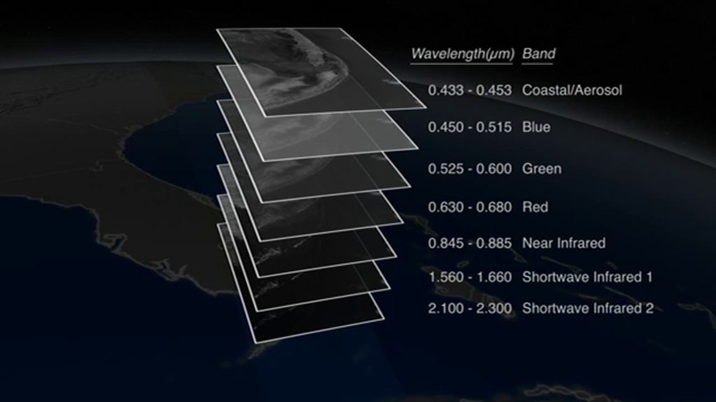
Print resolution still of the different Landsat bands exploded out like layers of onion skin along with corresponding spectral band wavelengths and common band names.
Print resolution still of the LDCM satellite collecting data over the Florida Everglades.
Print resolution still showing 3 bands of LDCM data remapped to red, green, and blue colors.
Credits
Please give credit for this item to:
NASA's Goddard Space Flight Center Scientific Visualization Studio
-
Animators
- Alex Kekesi (Global Science and Technology, Inc.)
- Greg Shirah (NASA/GSFC)
- Rachel Kreutzinger (USRA)
-
Producers
- Matthew R. Radcliff (USRA)
- Holli Riebeek (Sigma Space Corporation)
-
Scientist
- James R. Irons (NASA/GSFC)
Release date
This page was originally published on Tuesday, February 5, 2013.
This page was last updated on Tuesday, November 14, 2023 at 12:04 AM EST.
Missions
This visualization is related to the following missions:Series
This visualization can be found in the following series:Datasets used in this visualization
-
Band Combination 3-2-1 [Landsat-5: TM]
ID: 337 -
Band Combination 4, 3, 2 [Landsat-5: TM]
ID: 636 -
Band Combination 7,4,2 [Landsat-5: TM]
ID: 769
Note: While we identify the data sets used in these visualizations, we do not store any further details, nor the data sets themselves on our site.
Related
- ID: 11491
 Produced Video