Measuring the Seas from Space! U.S.-European Satellite Launching THIS SATURDAY Seeks to Answer Vital Climate Questions Live Shots

Click here for: Sentinel-6 Michael Freilich Media Reel. Includes links to associated b-roll
Click HERE for lightly edited b-roll showing the launch animation and the satellite in orbit.
Click here for the PRESS KIT
Click here for social media video in SPANISH
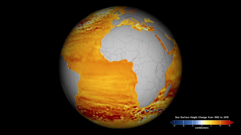
Earth’s climate is changing, and one of the clearest signs is rising sea levels in the world’s oceans. THIS Saturday, a U.S.- European collaboration will launch the first of two satellites that will track sea level height over the next decade.
NASA and NOAA scientists are available virtually Friday, November 20 from 6:00 a.m. - 12:30 p.m. EST and 7:00 p.m. - 9:30 p.m. EST - one day before launch - and again Saturday, November 21 from 7:00 a.m. - 9:30 a.m. EST - just hours before launch scheduled for 12:17 p.m. EST from Vandenberg Air Force Base in California - to tell your viewers when they can watch the launch, and why it is important to document changing sea level.
The Sentinel-6 Michael Freilich satellite will add vital measurements to a nearly 30-year record of sea level observations, giving us valuable insight to how the oceans are responding to climate change. This newest satellite will continue the longest-running series of missions dedicated to answering this question: How fast are Earth’s oceans rising and how will that impact us?
The mission consists of two identical satellites, Sentinel-6 Michael Freilich and Sentinel-6B, that will launch five years apart. Along with observing sea levels, these satellites will also provide precise data of atmospheric temperature and humidity that will help improve weather forecasts and climate models.
To Schedule an interview:
Please fill out this form: https://forms.gle/8hm3u5sG8mukMQLN7
Interviews will be conducted using video chat programs including Skype in 15-minute slots. For example 600-615 ET, 615-630 ET, etc. Satellite interviews are not available. Spanish Interviews are available
Participating Scientists:
Thomas Zurbuchen / Associate Administrator for the Science Mission Directorate, NASA Headquarters
Karen St. Germain / Earth Science Division Director, NASA Headquarters
Nadya Vinogradova Shiffer / Sentinel-6 Michael Freilich Program Scientist, NASA Headquarters
Ivona Cetinic / NASA Oceanographer, USRA
Michelle Easter / JPL, Mechatronics Engineer
Ben Hamlington / JPL, Research Scientist
Josh Willis / JPL Project Scientist for Sentinel-6
Shannon Statham / JPL, Sentinel-6 AMR-C Integration & Test Lead
Thomas Thammasuckdi / JPL, Ground Data Software Engineer Lead
Steve Nerem / University of Colorado, Professor, Aerospace Engineering Sciences
Eric Leuliette / NOAA, Sentinel-6 Project Scientist
Carlos Del Castillo / NASA Scientist [Interviews in Spanish]
Erika Podest / JPL, climate scientist [Interviews in Spanish]
Pedro E. Moreira / JPL, Payload Development / Mechanical Engineer [Interviews in Spanish]
Suggested Questions:
Tell us about the new mission that is launching this weekend to better understand sea level rise?
Why is measuring sea level important? What does it tell us about climate change?
Why do we use satellites to observe the ocean? How do you do that from space?
How will data from Sentinel-6 Michael Freilich ( Fry-lick) Satellite help to improve weather forecasts, such as the models that track the formation and evolution of hurricanes?
How does sea level rise affect us here in XXXX?
What is your role on the mission, and what excites you about it?
Where can people learn more and stay up to date on this mission?
Suggested Anchor Intro:
GLOBAL SEA LEVEL RISE IS ONE OF THE MOST DISTINCTIVE INDICATORS OF CHANGES IN OUR CLIMATE. NOW, NASA, IN COLLABORATION WITH EUROPEAN PARTNERS AND NOAA, IS LAUNCHING THE FIRST OF TWO SATELLITES THAT WILL EXTEND THE RECORD OF SEA LEVEL MEASUREMENTS THROUGH 2030.
THE SENTINEL-6 MICHAEL FREILICH SATELLITE WILL ADD TO NEARLY 30 YEARS OF SEA LEVEL RECORDS AND WILL HELP ANSWER VITAL CLIMATE QUESTIONS. TODAY WE HAVE A NASA/NOAA TEAM MEMBER … TO TALK ABOUT THIS IMPORTANT MISSION...
Includes lightly edited b-roll from the launch animation sequence and various animations of the satellite in orbit
Social media video in Spanish about the Sentinel6 Michael Freilich satellite. Soundbites with Erika Podest / JPL, climate scientist. TRT 4:12
For More Information
See the following sources:
- 5 Things to Know About Sentinel-6 Michael Freilich
- New Sea Level Satellite Arrives at California Launch Site
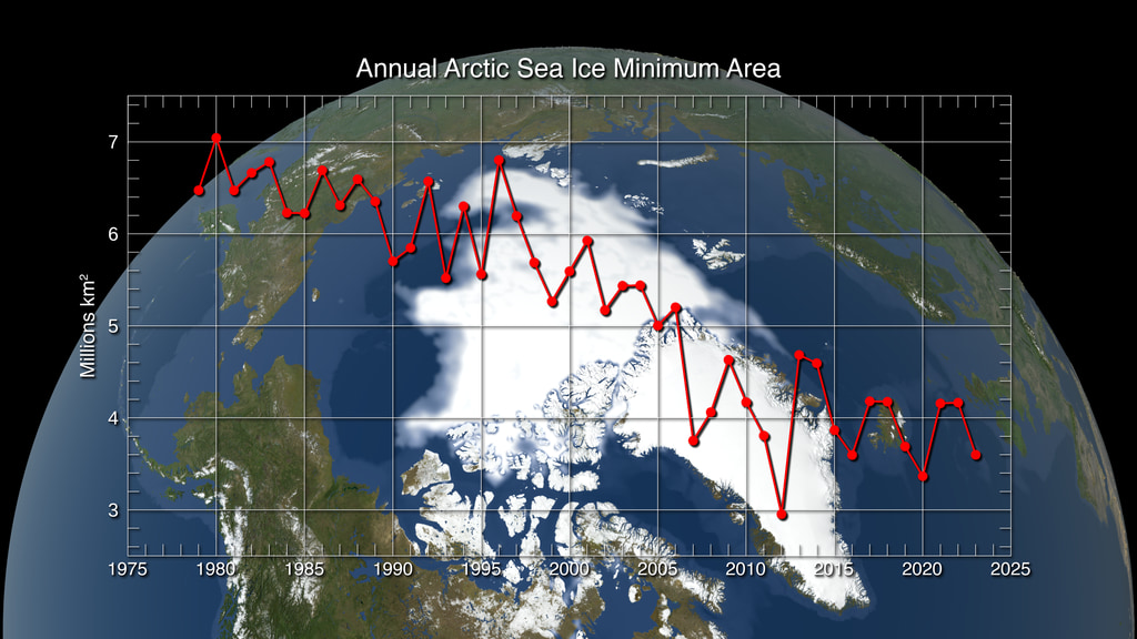
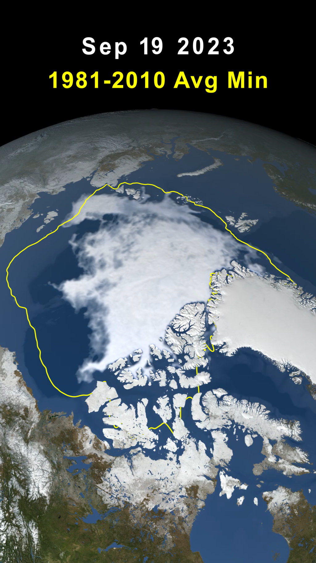
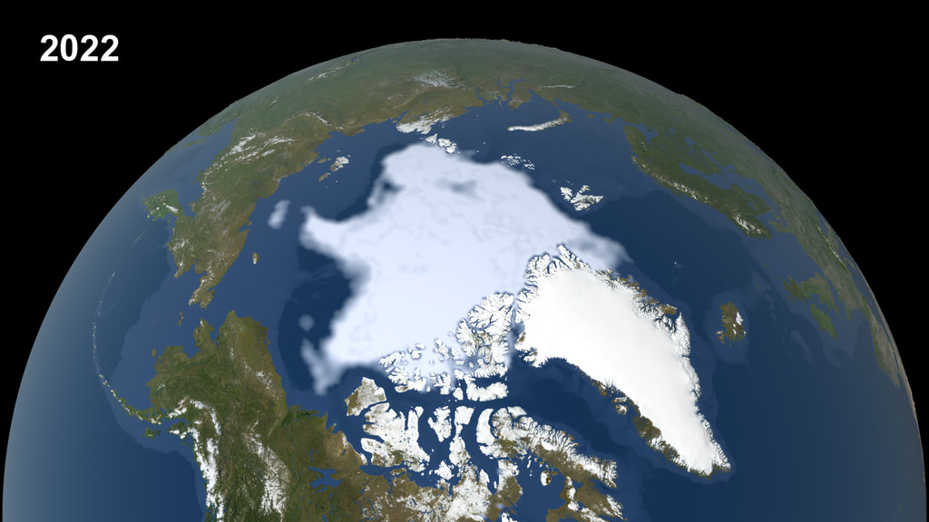
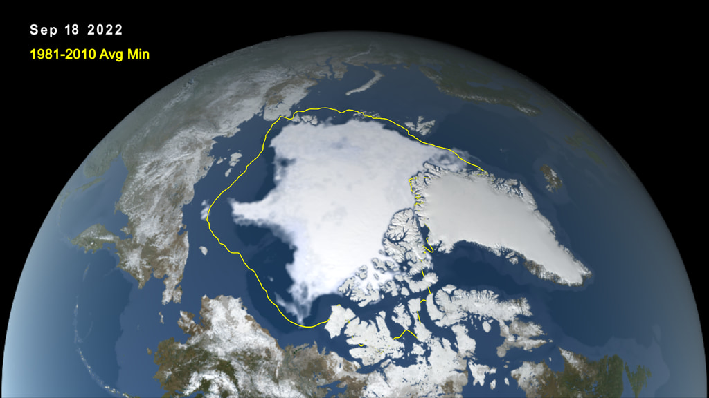
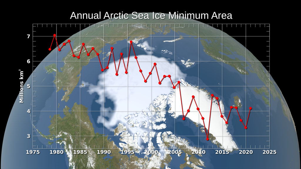
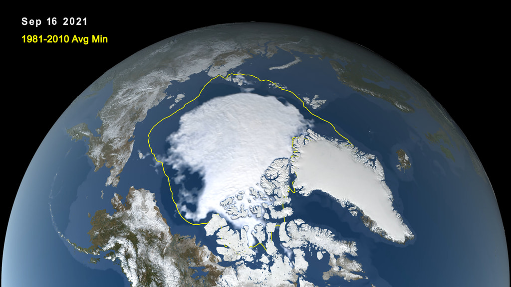
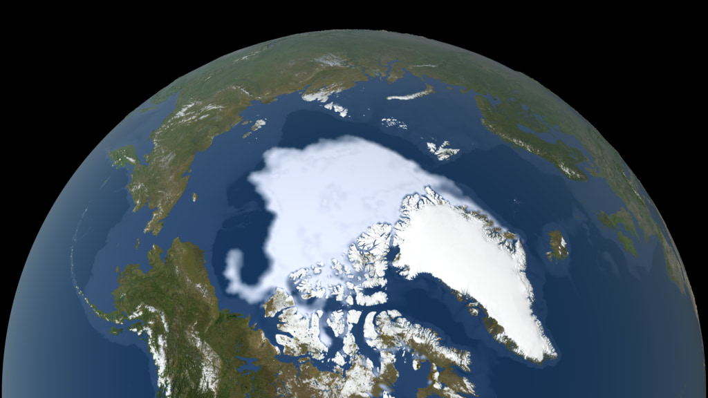
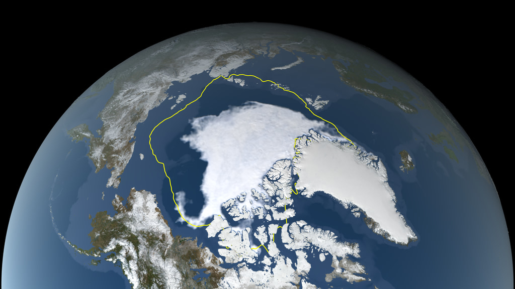
- 2020 Arctic Sea Ice Minimum at Second Lowest on Record
- Upcoming Satellite Mission will Improve Hurricane Forecasts and Climate Science, NOAA Expert Says
- Keeping a Steady Eye on Sea Level Change From Space
- The Science of Earth's Rising Seas
- New Earth Mission Will Track Rising Oceans Into 2030
Credits
Please give credit for this item to:
NASA's Goddard Space Flight Center
-
Producers
- Michelle Handleman (USRA)
- Courtney A. Lee (ADNET Systems, Inc.)
- Victoria Woodburn (GSFC Interns)
- Christina Brooke Mitchell (KBR Wyle Services, LLC)
- Madison Arnold (NASA/GSFC)
- Pedro Cota (ADNET Systems, Inc.)
-
Technical support
- Aaron E. Lepsch (ADNET Systems, Inc.)
Release date
This page was originally published on Tuesday, November 17, 2020.
This page was last updated on Wednesday, May 3, 2023 at 1:44 PM EDT.
Related
- ID: 5170
 Visualization
 - ID: 5162
 Visualization
 - ID: 5036
 Visualization
 - ID: 5030
 Visualization
 - ID: 5002
 Visualization
 - ID: 4928
 Visualization
 - ID: 4941
 Visualization
 - ID: 4931
 Visualization
 - ID: 4853
 Visualization
 - ID: 4867
 Visualization
 - ID: 4860
 Visualization
 - ID: 13577
![VIDEO: "Witness the Breathtaking Beauty of Earth’s Polar Regions"
Operation IceBridge recorded the diversity and fragility of our rapidly changing polar regions. These areas are some of the most inhospitable, but breathtaking places on Earth. Sit back and witness the polar regions, from western Greenland to Antarctica. Notable features include the Pine Island Glacier, Larsen C ice shelf, and rapid summer melt on the western Greenland Ice Sheet.
Learn more: Operation IceBridge
Music Provided by Universal Production Music: "Arabesque No.1" by Claude Debussy [PD]
This video is also available on our YouTube channel.](/vis/a010000/a013500/a013577/13577_Cryosphere_Beauty_Classic.00018_print.jpg)
- ID: 4772
 Visualization