Economics of Nature: Mapping Liberia’s Ecosystems to Understand Their Value
This video can be freely shared and downloaded. While the video in its entirety can be shared without permission, some individual imagery provided by pond5.com, Artbeats, and Conservation International is obtained through permission and may not be excised or remixed in other products. Specific details on stock footage may be found here. For more information on NASA’s media guidelines, visit https://www.nasa.gov/multimedia/guidelines/index.html.
Complete transcript available.
Music Credit:
Universal Production Music: In Doubt (Instrumental) by Claire Leona Batchelor [PRS], Find the Truth (Instrumental) by Paul Russell [PRS]
Notes on Footage:
Provided by Conservation International: 00:00-00:45; 01:03-01:33; 01:53-02:10; 02:12-02:22; 02:57-03:13; 04:00-04:04
Stock: 01:33–01:37 provided by ABSTRACTICA/Pond5; 02:10-02:12 provided by Artbeats; 02:22–02:25 provided by Longjourney/Pond5
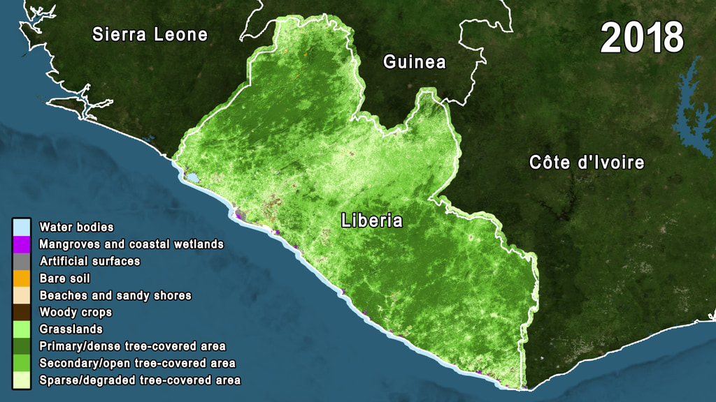
NASA is working alongside Conservation International and the Liberian Government through the Environmental Protection Agency (EPA) to pilot an innovative and replicable approach to more accurately map ecosystems to support effective planning and sustainable decision-making. A NASA research team has made land cover maps of the entire country for every year in the last two decades using images from the joint NASA and United States Geological Survey’s Landsat mission. The team then refined the classifications using very high resolution commercial satellite data and tree height information from the Global Ecosystem Dynamics Investigation (GEDI) program
Conservation International and the Liberian Government through the EPA refined those land cover maps using biodiversity information from their field studies and local knowledge from Liberian communities. The efforts of Conservation International and the Liberian Government through the EPA, combined with the NASA land cover maps, yield ecosystem extent maps which depict the changes in ecosystem types across the country.
For More Information
Credits
Please give credit for this item to:
NASA's Scientific Visualization Studio
-
Producer
- Katie Jepson (USRA)
-
Writer
- Sofie Bates (KBR Wyle Services, LLC)
-
Visualizer
- Trent L. Schindler (USRA)
-
Scientists
- Celio de Sousa (USRA)
- Trond Larsen (Conservation International)
- Chris Neigh (NASA/GSFC)
- Temilola Fatoyinbo (NASA/GSFC)
- Daniel Juhn (Conservation International)
Release date
This page was originally published on Thursday, March 11, 2021.
This page was last updated on Wednesday, May 3, 2023 at 1:44 PM EDT.
Missions
This visualization is related to the following missions:Series
This visualization can be found in the following series:Sources
- ID: 4836
 Visualization