NASA Studies Hurricane Edouard in HS3 Mission (2014)
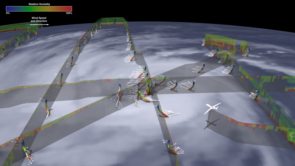
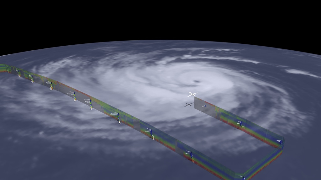
NASA's Global Hawk in 2014 traveled to the middle of the Atlantic and flew over Hurricane Edouard. Remote sensing nstruments on the plane measured temperature, relative humidity, wind speed, wind direction as well as other data. Along with measurements from the aircraft, NASA scientists also collected data from dropsondes that parachuted down through the hurricane.
Complete transcript available.
Music: Who Done It? by Robert Leslie Bennett [ASCAP]
Watch this video on the NASA Goddard YouTube channel.
The swirling nature of hurricane clouds are a familiar sight in satellite imagery, but in order to better understand these storms, scientists need to look inside them. In 2014, NASA's remotely piloted Global Hawk aircraft flew over Hurricane Edouard in the Atlantic Ocean to help better understand what makes hurricanes intensify.
During the 24-hour flight, a sounder instrument measured the relative humidity of the storm from above, where the cloud cover was thin. Where clouds were too thick, including around the eye of the hurricane, the Global Hawk released dropsondes – foot-long sensors that dropped from the aircraft down through the storm to the ocean's surface – sending back data on humidity, temperature and wind the whole way down. Warm, moist air helps to give hurricanes their strength, and near the eye, the red colors show high humidity powering the storm. Scientists use these and other data collected from these flights to better understand the environmental signals inside and outside of the hurricanes. They want to better understand the signals that lead to rapid intensification where wind speeds dramatically increase in a 24-hour period – vital information for anyone in the storm's path.Hurricane and Severe Storm Sentinel (HS3) is a mission to investigate the processes that underlie hurricane formation and intensity change in the Atlantic Ocean basin.
Credits
Please give credit for this item to:
NASA's Goddard Space Flight Center
-
Scientist
- Scott Braun (NASA/GSFC)
-
Animator
- Kel Elkins (USRA)
-
Writer
- Ellen T. Gray (ADNET Systems, Inc.)
-
Producer
- Matthew R. Radcliff (USRA)
Release date
This page was originally published on Thursday, May 31, 2018.
This page was last updated on Wednesday, May 3, 2023 at 1:46 PM EDT.
Missions
This visualization is related to the following missions:Series
This visualization can be found in the following series:Sources
- ID: 4456
 Visualization
Used as a Source In
- ID: 13216
![Complete transcript available.Music credits: “Northern Breeze” by Denis Levaillant [SACEM], “Stunning Horizon” by Maxime Lebidois [SACEM], Ronan Maillard [SACEM], “Magnetic Force” by JC Lemay [SACEM] from Killer TracksWatch this video on the NASA Goddard YouTube channel.This video can be freely shared and downloaded. While the video in its entirety can be shared without permission, some individual imagery provided by pond5.com is obtained through permission and may not be excised or remixed in other products. Specific details on stock footage may be found here. For more information on NASA’s media guidelines, visit https://www.nasa.gov/multimedia/guidelines/index.html.Notes on footage:• 0:03 - 0:17 provided by Pond5• 1:38 - 1.43 provided by Pond5• 1:49 - 1:52 provided by Pond5• 2:21 - 1:27 provided by Pond5](/vis/a010000/a013200/a013216/13216_NASA_Has_Eyes_On_The_Atlantic_Hurricane_Season_YouTube.00050_print.jpg) Produced Video
Produced Video - ID: 12948
 Produced Video