NASA Satellites See Wildfires from Space
As wildfires burn across California, NASA satellites help gather data about where the fires are and how smoke travels across the state.
The smoke from the fires is even visible a million miles away from Earth, captured by NASA's Earth Polychromatic Imaging Camera (EPIC) onboard NOAA's Deep Space Climate Observatory (DSCOVR).
The Terra spacecraft can see fires in both daylight and at night, helping aid firefighters in tracking and stopping the blazes.
NASA's unique vantage point in space helps better understand our home planet.
Terra Imagery from NASA Worldview
Music: Seven by Andrea Sacco [SACEM]
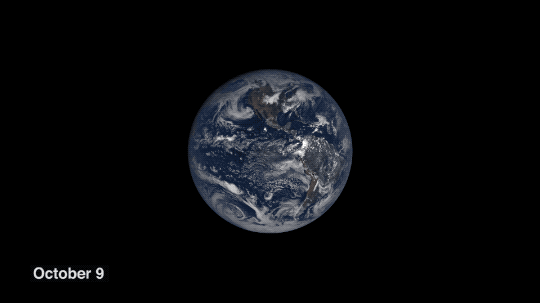
The Earth Polychromatic Imaging Camera (EPIC) onboard NOAA's Deep Space Climate Observatory (DSCOVR) captured this image on Oct. 9, 2017.
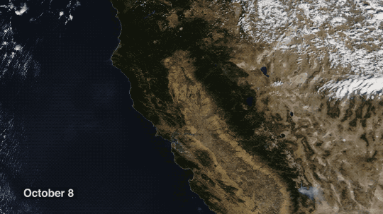
The Moderate Resolution Imaging Spectrometer (MODIS) onboard NASA's Terra spacecraft captured these images from Oct. 8-10, 2017.

These images were captured with NASA's Terra spacecraft's thermal bands from Oct. 9-11, 2017.
Credits
Please give credit for this item to:
NASA's Goddard Space Flight Center
-
Producers
- Kathryn Mersmann (USRA)
- Jefferson Beck (USRA)
Release date
This page was originally published on Wednesday, October 11, 2017.
This page was last updated on Wednesday, May 3, 2023 at 1:47 PM EDT.
Used as a Source In
- ID: 13891
![Music: “Cherry on Top” by Ben Beiny [PRS] from Universal Production MusicComplete transcript available.](/vis/a010000/a013800/a013891/13891_EPIC_Eclipse2021_YouTube.00358_print.jpg)