Small Satellites for Earth Science
NASA has embraced the revolution in small spacecraft and satellites, from CubeSats you can hold in your hand to microsatellites the size of a small washing machine. The technology helps advance scientific and human exploration, reduces the cost of new missions, and expands access to space. The briefing will discuss NASA's overall program, technology development initiatives, and new Earth-observing missions that use individual and constellations of small satellites to study climate change, hurricanes and clouds.
Briefing Panelists
Ellen Stofan, chief scientists at NASA Headquarters in Washington
Thomas Zurbuchen, associate administrator for the Science Mission Directorate at NASA Headquarters
Steve Jurczyk, associate administrator for the Science Mission Directorate at NASA Headquarters
Michael Freilich, director of the Earth Science Division at NASA Headquarters
Aaron Ridley, mission constellation scientist for NASA's Cyclone Global Navigation Satellite System (CYGNSS) at the University of Michigan in Ann Arbor
Bill Swartz, CubeSat principal investigator for the Radiometer Assessment using Vertically Aligned Nanotubes (RAVAN) project at Johns Hopkins University Applied Physics Laboratory in Laurel, Maryland
William Blackwell, principal investigator for the Time-Resolved Observations of Precipitation structure and storm Intensity with a Constellation of Smallsat (TROPICS) mission at the Massachusetts Institute of Technology Lincoln Laboratory, Lexington, Mass.
More information is available.

Figure 1 Tropical cyclone track forecasts have improved in accuracy by ~50% since 1990, but there has been essentially no improvement in the accuracy of intensity forecasts. We need wind measurements IN the hurricane.
Credit: NOAA/NWS
Figure 2 Top panel: Historical storm tracks. Bottom left panel: CYGNSS measurements from one orbit over 1.5 hours. Bottom right panel: CYGNSS measurements from 15 orbits over 24 hours.
Credit: University of Michigan
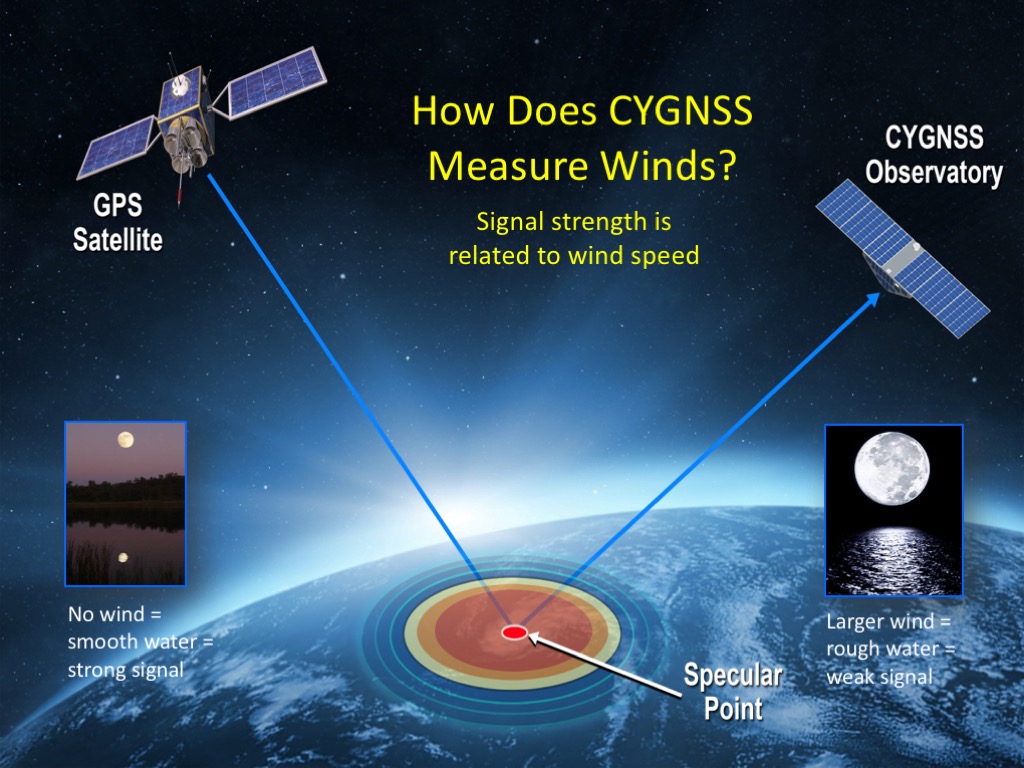
Figure 3 The CYGNSS mission takes advantage of GPS signals bouncing off the ocean to measure wind speed. Eight identical small satellites, each about the size of a microwave oven, flying in formation carry custom modified GPS receivers pointed at the oceans. When the water is smooth – not windy – the GPS signals reflect back uniformly, like the moon on a pond reflected as if in a mirror. When the water is choppy – windy – the signals reflect back in in the same direction but distorted, like the moon reflection on a choppy pond being distorted by ripples.
Credit: University of Michigan
Credit: University of Michigan
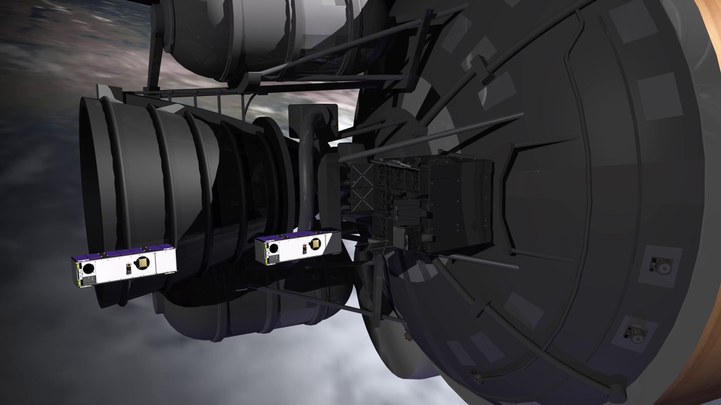
Figure 4 Top: Artist drawing of one of the eight CYGNSS satellites in orbit.
Bottom: A CYGNSS satellite in the lab during construction.
Credit: University of Michigan
Figure 5 All eight CYGNSS observatories prepped for launch on the Pegasus rocket. Launch is currently scheduled for Dec. 12, 2016 from Cape Canaveral, Florida.
Credit: University of Michigan
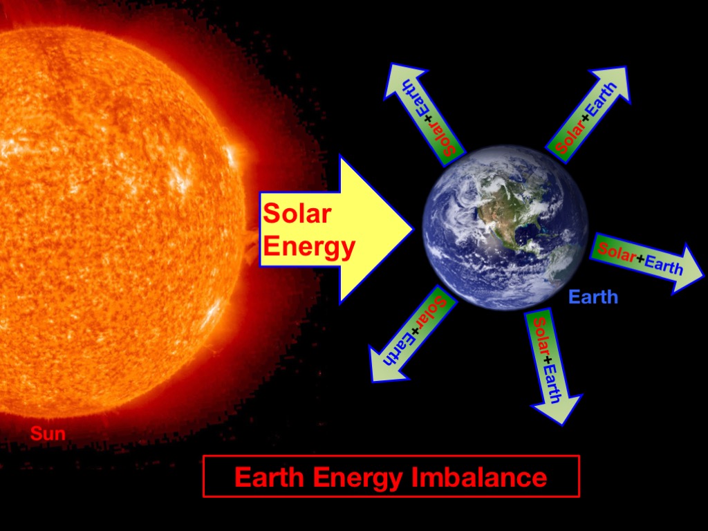
Figure 6 Climate change occurs when there is a change in the balance between incoming energy and outgoing energy from Earth. Virtually all the energy input to Earth comes from the sun. This is approximately balanced by Earth putting energy back into space from a combination of reflected solar energy and thermally emitted energy. The inputs and outputs are not exactly balanced. Part of the reason is greenhouse gases, which trap some of the energy that would otherwise go back to space. This small imbalance leads to changes in Earth’s climate.
Credit: Johns Hopkins University Applied Physics Laboratory
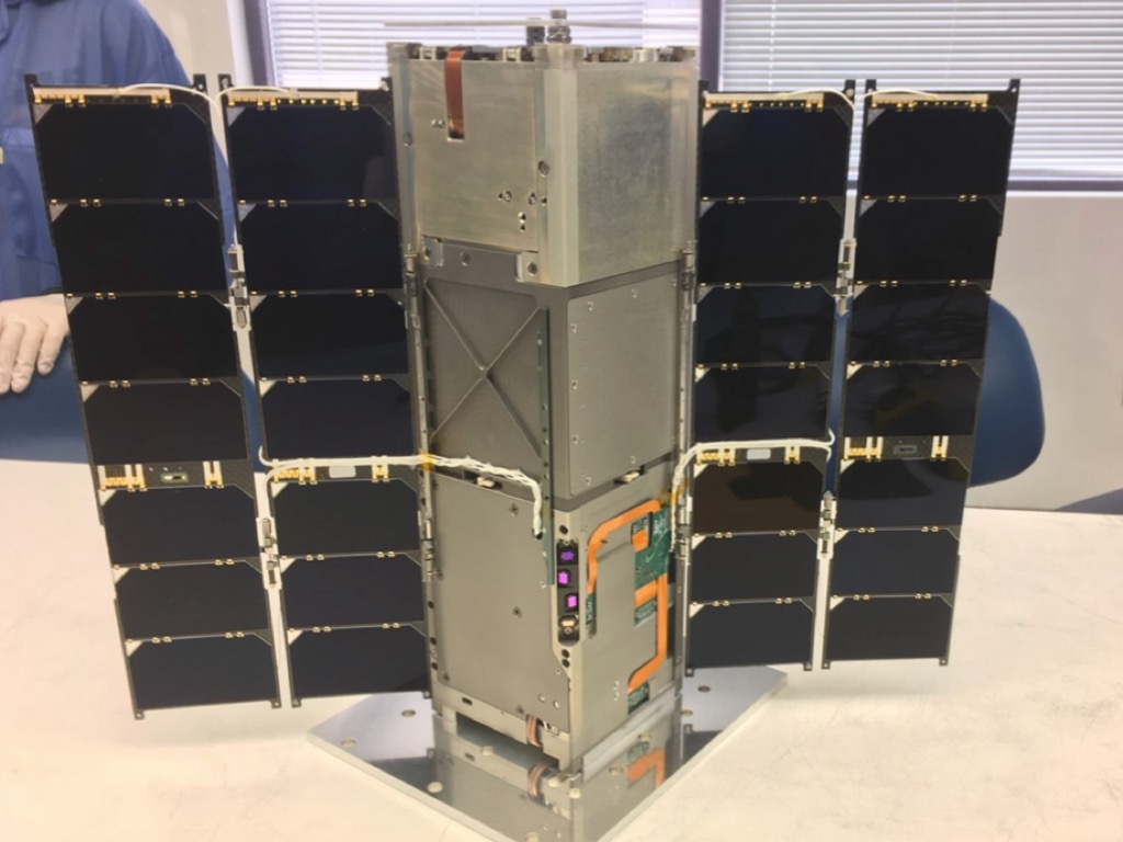
Figure 7 Radiometer Assessment using Vertically Aligned Nanotubes, or RAVAN, is a 3 Unit CubeSat that is going to demonstrate new technologies for measuring energy at the top of the atmosphere. These observations have the potential to improve spaceborne measurements of Earth’s energy imbalance in the future. RAVAN is funded by NASA’s Earth Science Technology Office.
Credit: Johns Hopkins University Applied Physics Laboratory
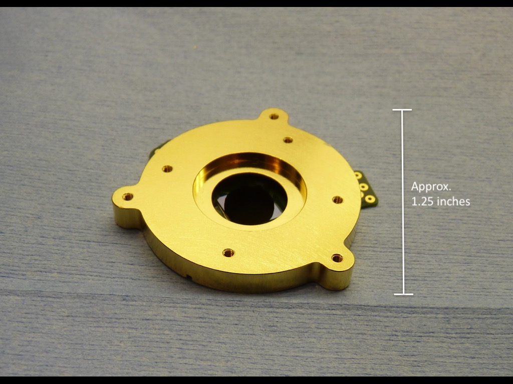
Figure 8 RAVAN will demonstrate the use of vertically aligned carbon nanotubes as the absorber in a compact and accurate radiometer. The carbon nanotubes stand on end like a bundle of straws or trees in a forest. They appear incredibly black because once energy is absorbed inside the tubes it is very difficult to reflect out. This makes them effective absorbers of Earth’s outgoing energy at ultraviolet, visible and infrared wavelengths of light. In the picture, the quarter inch patch in the center is a small “forest” of nanotubes.
Credit: Johns Hopkins University Applied Physics Laboratory
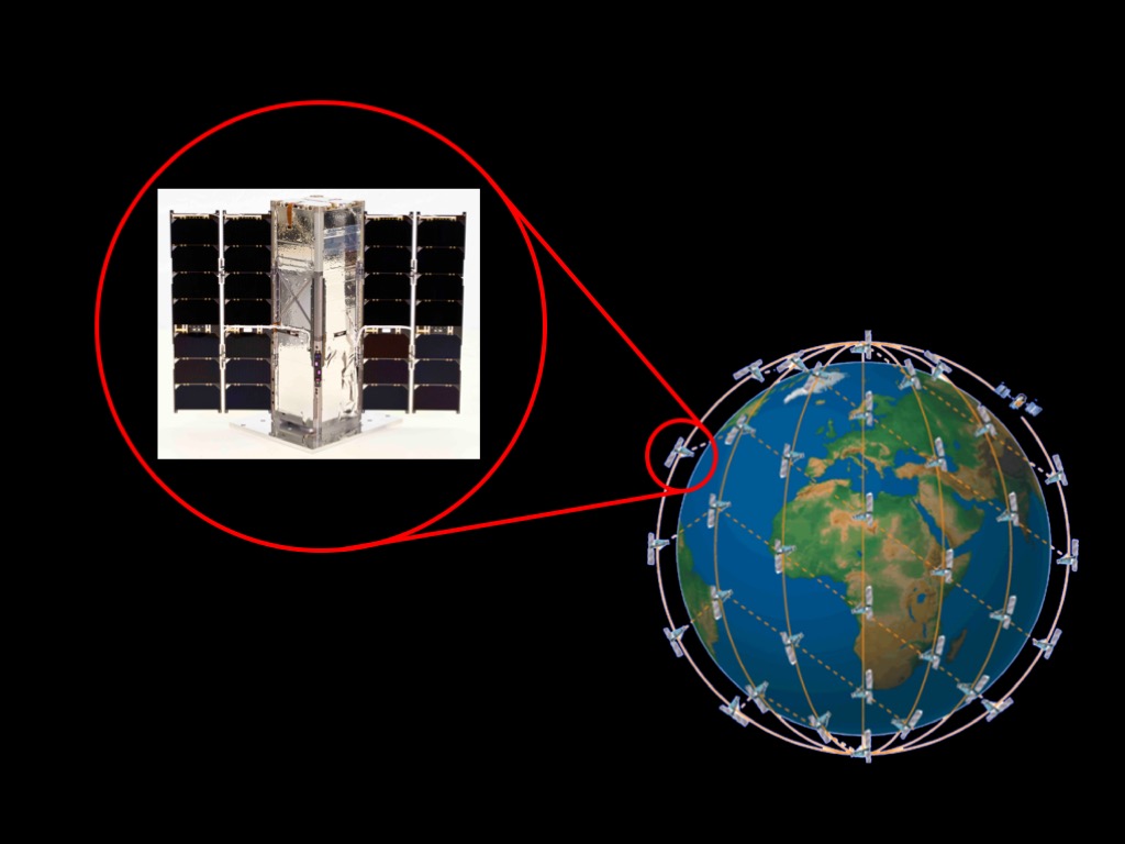
Figure 9 If the first RAVAN pathfinder mission is successful, the next step would be proposing a constellation of multiple RAVAN satellites distributed around the planet to measure Earth’s outgoing energy globally, 24/7.
Credit: Johns Hopkins University Applied Physics Laboratory
Figure 10 An important way to improve forecasts of tropical cyclone intensity is to see what’s going on inside and around them while they’re happening. That’s the goal of the TROPICS mission, 12 CubeSats that will fly in formation to track the temperature and humidity of storm environments. The TROPICS CubeSats will get very frequent measurements, similar to X-rays, that cut through the overall cloud-cover (black and white part of the image) so we can see the storm’s underlying structure (shown in color). The storm structures known as the eyewall – tall clouds, wind and rain around the eye – and rainbands – the rainy parts of the spiral arms – give us clues about whether a storm is primed to intensify into a category 4 or 5 storm, something everyone in their path needs to know.
Credit: Scott Braun, NASA GSFC (colored part of image); and Naval Research Laboratory (black/white part of image)
Figure 11 With 12 individual CubeSats, one of the TROPICS constellation CubeSats will fly over any part of the tropics (between 40 degrees latitude North and South) about every half hour. This frequent revisit time will allow the mission to capture the quickly changing features of tropical cyclones as they progress. Each CubeSat in the constellation is about the size of a loaf of bread and weighs eight pounds, flying 350 miles above Earth. They each host a sophisticated microwave instrument that scans across Earth’s surface once every two seconds to provide three-dimensional information on the storm’s structure, like a CAT-Scan. The CubeSats’ small size (relative to present weather satellites that can be almost as large as a SUV) allows them to be built and launched quickly and at low cost.
Credit: MIT Lincoln Laboratory
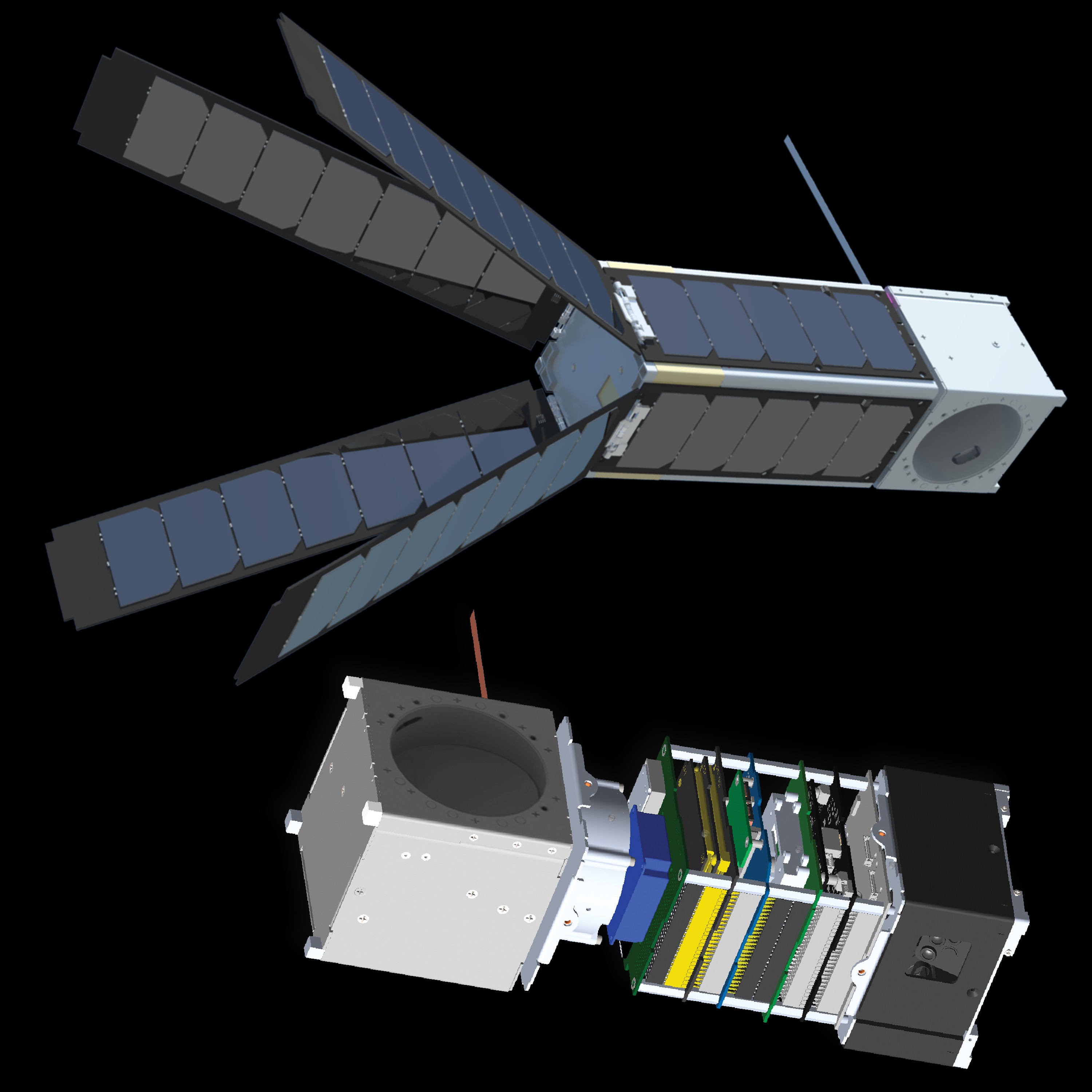
Figure 12 Each TROPICS CubeSat has three things: the science instrument, solar panels, and the spacecraft bus which runs the whole operation. The bus manages the power system, controls the spin and orientation of the instrument as well as its operation, and communicates with the ground over a radio link.
Over the last five years, technology has advanced rapidly to miniaturize the systems of both the spacecraft bus and the science instrument. This has led to the development of advanced components such as reaction wheels that spin up to 10,000 rotations per minute inside the spacecraft to keep it stable and high-resolution cameras that continuously track stars in the sky to enable attitude determination.
Previous NASA-funded CubeSat missions serve as pathfinders and test beds for these new technologies. One example that feeds into the TROPICS mission is the MiRaTA CubeSat project, led by Prof. Kerri Cahoy at MIT. Many of the key microwave instrument technologies were first developed and tested by the MiRaTA project, reducing risk for the TROPICS mission.
Credit: MIT Lincoln Laboratory
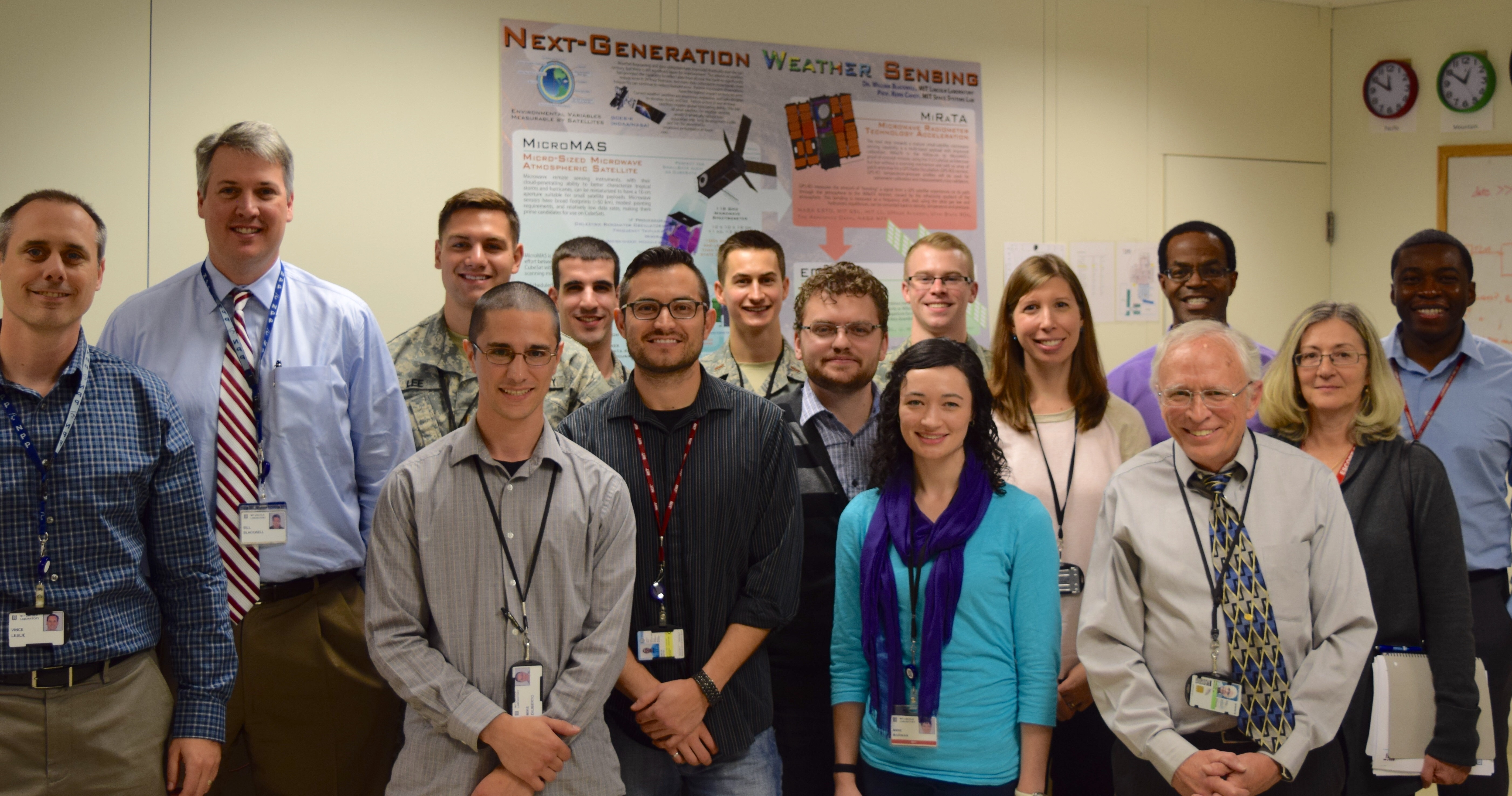
Figure 13 The TROPICS and MiRaTA projects are made up of a broad team drawing from a national lab (MIT Lincoln Laboratory), universities (including MIT and University of Massachusetts), NASA, and NOAA. Students involved in the projects bring boundless energy that can be effectively brought to bear under the guidance of seasoned experts and faculty.
Credit: MIT Lincoln Laboratory
Credits
Please give credit for this item to:
NASA's Goddard Space Flight Center
-
Producer
- Kathryn Mersmann (USRA)
-
Technical support
- Aaron E. Lepsch (ADNET Systems, Inc.)
-
Writer
- Ellen T. Gray (ADNET Systems, Inc.)
-
Scientists
- Aaron Ridley (University of Michigan)
- Bill Swartz (Johns Hopkins University/APL)
- William J. Blackwell (MIT Lincoln Laboratory)
Release date
This page was originally published on Monday, November 7, 2016.
This page was last updated on Tuesday, November 14, 2023 at 12:19 AM EST.
Related
- ID: 12411