El Niño Evolution

Computer models help scientists see El Niño unfold in the Pacific.
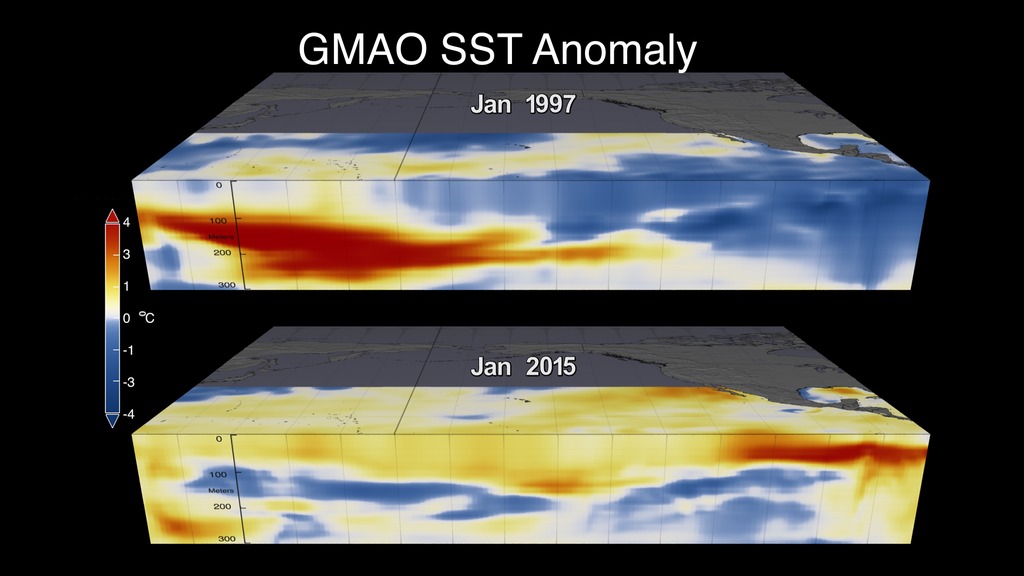
Every two to seven years, an unusually warm pool of water—sometimes two to three degrees Celsius higher than normal—develops across the eastern equatorial Pacific Ocean. This warm condition, known as El Niño, can disrupt marine ecosystems and spur extreme weather patterns around the world. To predict when an El Niño is coming, NASA scientists use computer models that simulate ocean temperatures in the Pacific. During an El Niño, changes in ocean temperatures are typically observed on the sea surface and up to 1,000 feet deep. With inputs from ocean buoys, satellite data and other sources, the models show what ocean temperatures might look like months into the future. The information not only helps scientists estimate the strength of an El Niño, but also study its evolution. Watch the video to learn more.
NASA scientist Robin Kovach talks about the effects of this year's El Niño and its development in this video.
This map shows unusually warm water (red, yellow) traveling east across the equatorial Pacific Ocean during the 2015 El Niño.
The warm water forms a thick layer beneath the ocean’s surface that extends up to 1,000 feet in depth.
Microscopic plants called phytoplankton are among the marine species that can be negatively impacted by an El Niño.
Credits
Please give credit for this item to:
NASA's Goddard Space Flight Center
Cover image courtesy of NASA
-
Writers
- None None (NASA Viz Team)
- Kasha Patel (Wyle Information Systems)
- Kate Ramsayer (Telophase)
- Ellen T. Gray (ADNET Systems, Inc.)
-
Producers
- Kayvon Sharghi (USRA)
- Sophia Roberts (USRA)
-
Video editor
- Sophia Roberts (USRA)
-
Videographers
- Rob Andreoli (Advocates in Manpower Management, Inc.)
- John Caldwell (Advocates in Manpower Management, Inc.)
-
Scientists
- Robin Kovach (SSAI)
- Steven Pawson (NASA/GSFC)
-
Interviewee
- Robin Kovach (SSAI)
-
Animator
- Lori Perkins (NASA/GSFC)
Release date
This page was originally published on Thursday, May 5, 2016.
This page was last updated on Wednesday, May 3, 2023 at 1:48 PM EDT.
Sources
- ID: 4433
- ID: 12157
 Produced Video