Monitoring Changes in the Chesapeake Bay Watershed
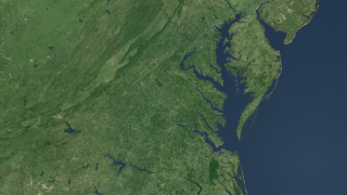
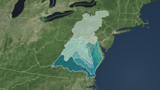
Landsat is a critical and invaluable tool for characterizing the landscape and mapping it over time. Landsat data provides a baseline of observations for science about how human activities on the land affect water quality, affect wildlife habitat, affect air quality. The satellite imagery covers the entire 64,000 square miles of the Chesapeake Bay watershed (spanning six states and the District of Columbia). Without it we wouldn't be able to really understand how sources of nutrients and sediment have changed and where they are in the Chesapeake Bay.
The Landsat Program is a series of Earth-observing satellite missions jointly managed by NASA and the U.S. Geological Survey.
The narration in this video is by Peter Claggett, a research geographer with the U.S. Geological Survey's Eastern Geographic Science Center. He has worked at the Chesapeake Bay Program Office since 2002, where he leads the Land Data Team that conducts research on land change characterization, analysis, and modeling in the Chesapeake Bay Watershed.
The audio was adapted from a radio interview with EarthSky.org.
Landsat imagery is critical for monitoring changes in developed area, tree canopy, farm fields, and all the landscapes that make up the 64,000 square miles of the Chesapeake Bay watershed, spanning six states and the District of Columbia.
For complete transcript, click here.
Watch this video on the NASA Goddard YouTube channel.
For More Information
Credits
Please give credit for this item to:
NASA's Goddard Space Flight Center
Audio adapted from EarthSky.org
-
Animators
- Helen-Nicole Kostis (USRA)
- Cindy Starr (Global Science and Technology, Inc.)
- Jeff de La Beaujardiere (NASA)
- Greg Shirah (NASA/GSFC)
-
Video editor
- Matthew R. Radcliff (USRA)
-
Producer
- Matthew R. Radcliff (USRA)
-
Scientist
- Peter Claggett (USGS)
Release date
This page was originally published on Thursday, January 31, 2013.
This page was last updated on Tuesday, November 14, 2023 at 12:18 AM EST.
Missions
This visualization is related to the following missions:Series
This visualization can be found in the following series:Tapes
This visualization originally appeared on the following tapes:-
Chesapeake Flyover
(ID: 2013020)
Friday, February 1, 2013 at 5:00AM
Produced by - Walt Feimer (HTSI)
Related
- ID: 3446
 Visualization
 - ID: 3472
 Visualization