The Night Electric
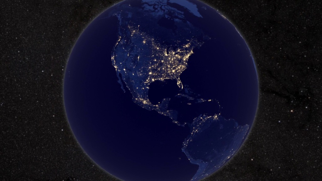
The night side of our planet twinkles with light, tracing a map of human settlement across Earth. Scientists have studied Earth's night lights in the past, using military satellites and astronaut photos; but in 2012, the view became significantly clearer. Data from the NASA-NOAA Suomi National Polar-orbiting Partnership (Suomi NPP) satellite was used to make a new composite view of Earth at night that allows scientists to quantify the intensity and sources of night light for the first time. A special low-light sensor on Suomi-NPP can distinguish night lights with six times better spatial resolution and 250 times better resolution of lighting levels than before, capturing even the dim light of an isolated highway lamp or a fishing boat at sea. Watch the videos to take a tour of Earth, sparkling in the dark of night.

A satellite looks back at Earth and sees a constellation of bustling cities and remote towns.
It took 312 satellite orbits and 2.5 terabytes of clear, cloud-free data to create this composite view of Earth at night.
A narrated tour takes you in close for highlights of what is being called "The Black Marble."
The Nile River Valley and Delta comprises 5 percent of Egypt's land area, but provides a home to 97 percent of its population.
While modernized South Korea gleams with city lights, North Korea appears dark. Lighted fishing boats dot the Yellow Sea.
Night light images, like this one of South America, distinguish urban versus rural areas and show where major population centers are.
Images like this of the U.S. have been used for research in sociology, economics, and urban planning.
For More Information
Credits
Please give credit for this item to:
NASA Earth Observatory and NASA's Goddard Space Flight Center
-
Animators
- Robert Simmon (Sigma Space Corporation)
- Jesse Allen (Sigma Space Corporation)
- Trent L. Schindler (USRA)
-
Video editor
- Kayvon Sharghi (USRA)
-
Narrator
- Horace Mitchell (NASA/GSFC)
-
Producers
- Kayvon Sharghi (USRA)
- Mike Carlowicz (Sigma Space Corporation)
-
Scientist
- Christopher Elvidge (NOAA/NGDC)
-
Writer
- Mike Carlowicz (Sigma Space Corporation)
Release date
This page was originally published on Thursday, December 27, 2012.
This page was last updated on Wednesday, May 3, 2023 at 1:52 PM EDT.
Related
- ID: 12396
 Produced Video
 - ID: 11157
 Produced Video