Extreme Turbulence
Why do some storms intensify into powerful hurricanes? In search of the answer NASA scientists took to the skies in 2010 aboard a flying laboratory that crisscrossed the path of Hurricane Earl as it approached the East Coast of the United States. By deploying canister-shaped sensors within the storm, researchers collected valuable data that will help them understand how such storms form and develop. But they weren't working alone: Soaring at an altitude of 60,000 feet, NASA's unmanned Global Hawk aircraft cruised over the Category 4 hurricane while astronauts on the International Space Station captured dramatic photos of its massive cloud tops from above. Wonder what it's like to fly through a hurricane? Watch the video to get a window seat view from the scientists' plane as it jetted into the eye of the storm.

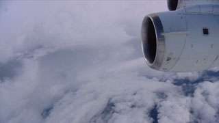
NASA scientists venture into the eye of a hurricane.
Experience the wing-rattling intensity of flying through the storm's eyewall and into the calm eye.
Making its first flight over a hurricane, NASA's Global Hawk aircraft ushers in a new era of storm science.
Hurricane Earl as seen from the International Space Station.
NASA's Aqua satellite captured this image of Hurricane Earl as the storm approached the Bahamas.
Radar data from NASA's TRMM satellite shows rainfall off the coast of the United States.
For More Information
See NASA.gov
Credits
Please give credit for this item to:
NASA's Goddard Space Flight Center
Global Hawk photo courtesy of NASA/NOAA
TRMM image courtesy of NASA/SSAI, Hal Pierce
ISS photos courtesy of NASA, Douglas Wheelock
Aqua image courtesy of NASA/MODIS Rapid Response Team
-
Producer
- Brooke Harris (USRA)
-
Videographer
- Jane Peterson (University of North Dakota)
-
Writer
- Patrick Lynch (Wyle Information Systems)
Release date
This page was originally published on Tuesday, September 4, 2012.
This page was last updated on Wednesday, May 3, 2023 at 1:52 PM EDT.
Related
- ID: 10638
 B-Roll